
By Alan Smith, Meteorologist Posted 2 days ago July 18, 2025
Monsoon Favors CO & NM, Rain Chances for the Northwest Early Next Week
Summary
A consistent monsoon pattern will settle in across Colorado, New Mexico, & Eastern Arizona this weekend & next week, while Northern Arizona & Utah will see a trend toward drier air & fewer t-storms heading into next week. A low pressure trough will also track across the Northwest Mon-Tue with showers & t-storms expected, some of which will produce heavy downpours.
Short Term Forecast
Helpful Links:
Friday Afternoon Conditions:
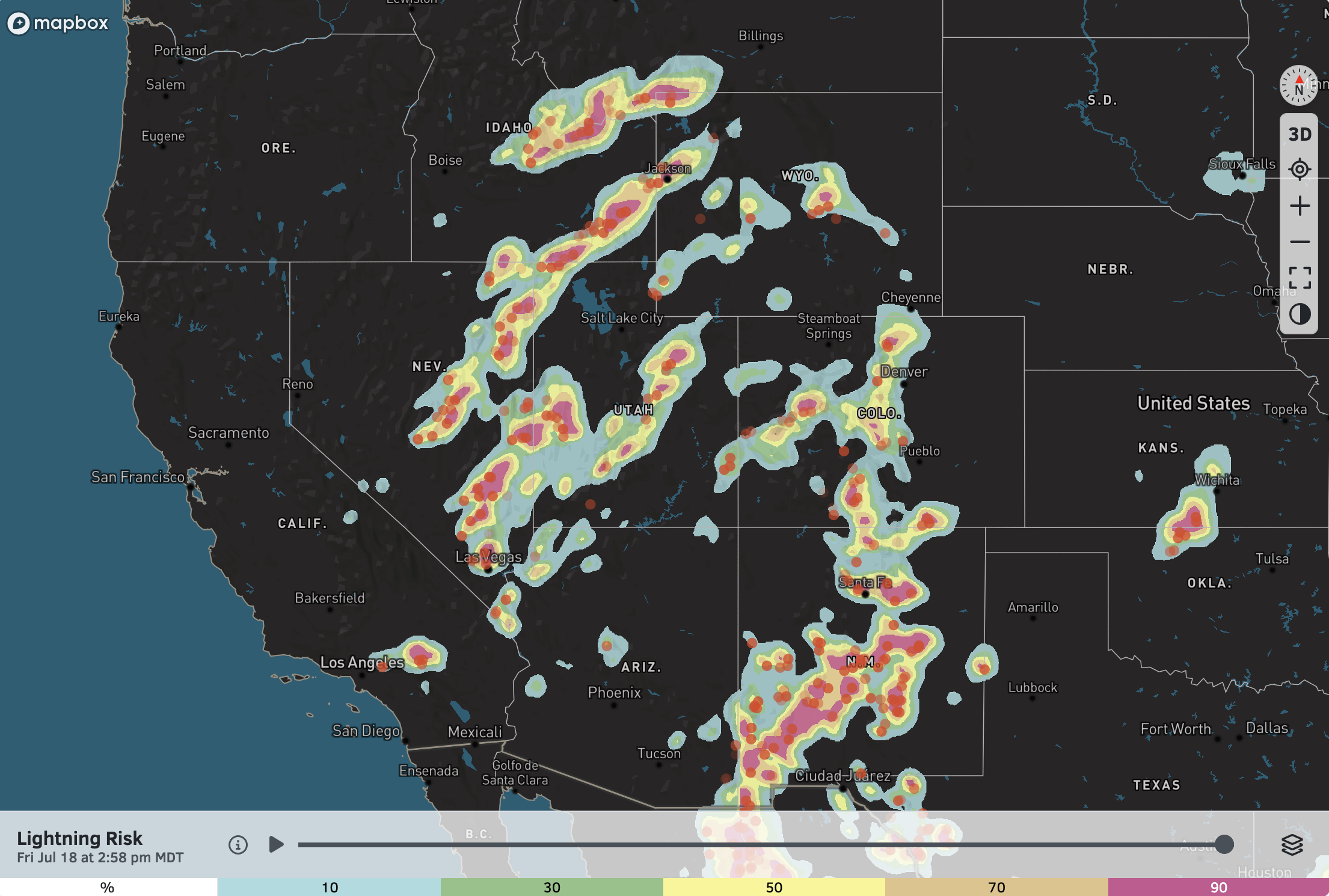
Friday has been an active day across the West, and it even started with rare mid-summer thunderstorms along the coast of Southern California early on Friday morning.
Friday afternoon has featured thunderstorms across the Southwest and the Central Rockies, with many storms producing heavy downpours and frequent cloud-to-ground lightning.
Lightning Strikes and Risk Map at 3:00 PM on Friday (July 18):
Wildfire Smoke Update:
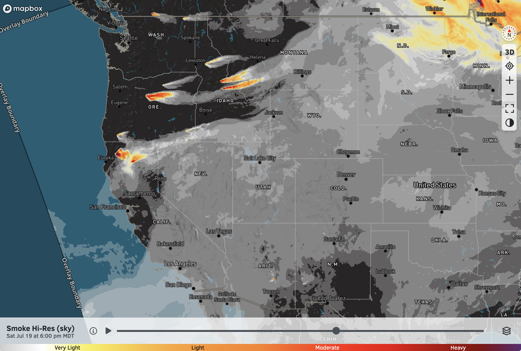
A decrease in wildfire smoke is expected across the Southwest and Colorado this weekend thanks to the uptick in monsoonal moisture, along with more cloud cover and cooler temperatures.
Several large fires are burning across the Interior Northwest, with locally heavy smoke expected near and just downwind of these fires.
High-Res Smoke (Sky) Forecast for 6 PM Saturday:
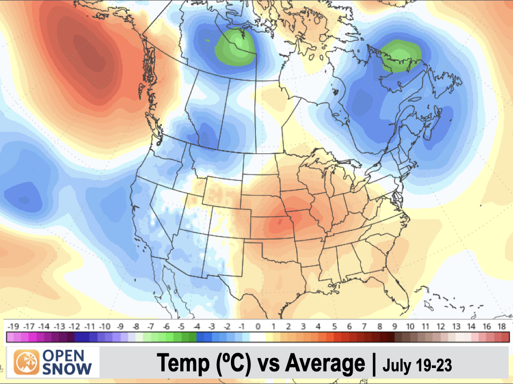
5-Day Temperature Outlook:
Temperatures will remain below normal across much of the West over the next 5 days, thanks to a trough-dominant pattern which will prevent any major heatwaves. Exceptions include portions of the Central Rockies and adjacent plains where near to above-normal temperatures will persist.
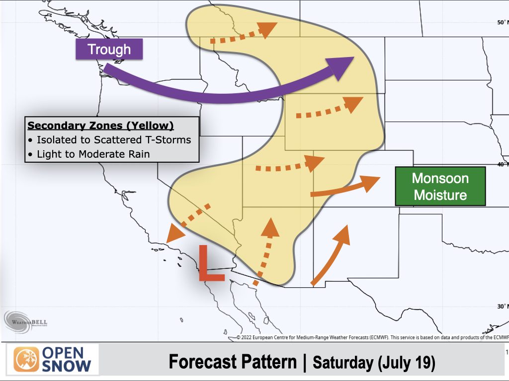
Saturday (July 19):
A trough will move across the Northern Rockies with drier air to the south of the trough scouring out some of the monsoonal moisture across Nevada, Arizona, Utah, and Wyoming. However, deeper moisture will remain over Eastern and Southern Colorado as well as New Mexico.
In Colorado, mountain ranges favored for the highest thunderstorm coverage include the Front Range, Tenmile/Mosquito Range, Sawatch Range, Sangre de Cristo Range, and San Juan Range.
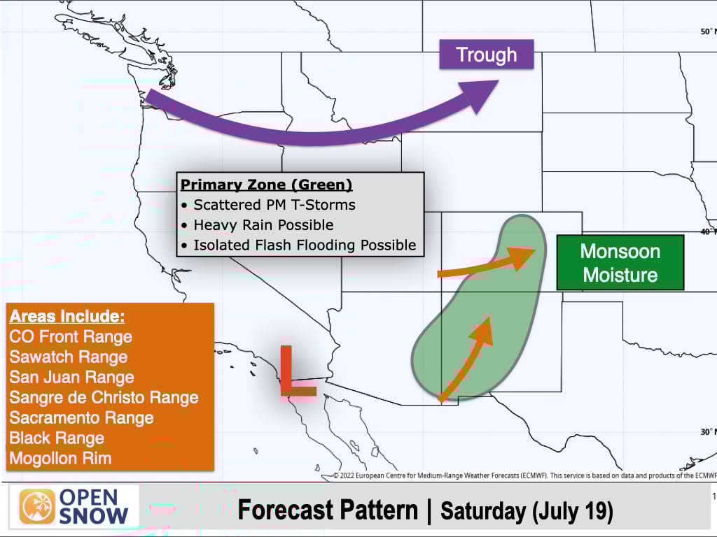
In the yellow-shaded areas, isolated to scattered thunderstorms can still be expected, with storms generally producing light to moderate rain. This includes much of Utah and Arizona, the Northern Rockies, and the Southern to Central Sierra.
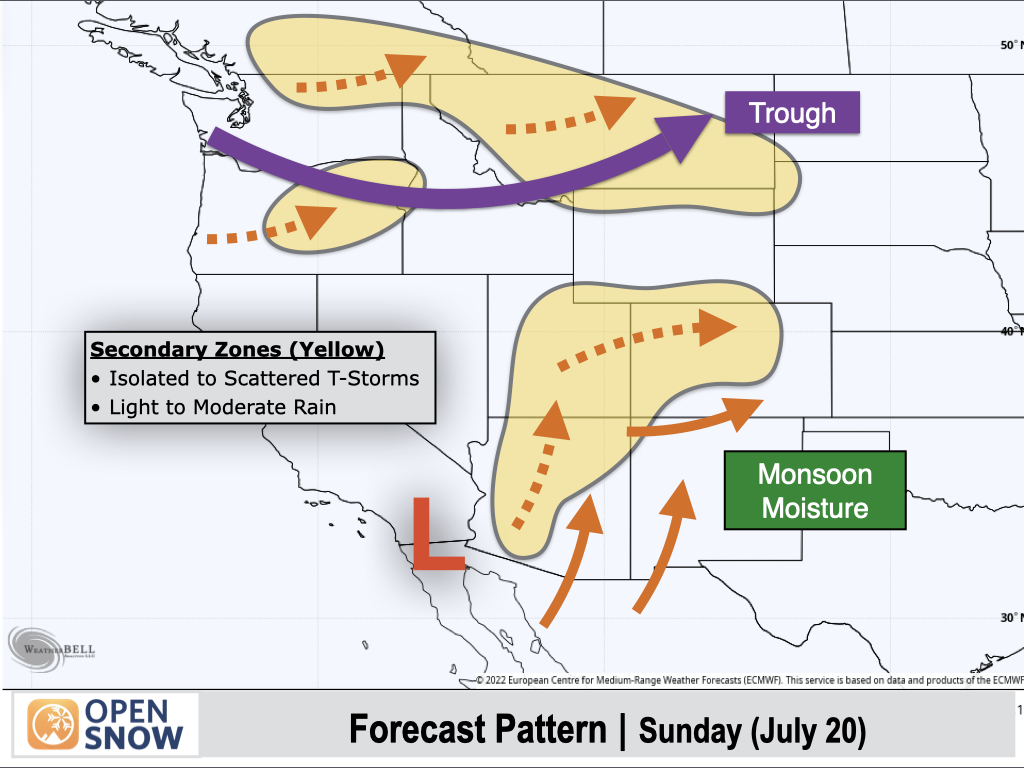
Sunday (July 20):
Another trough will move across the Northern Rockies with monsoonal moisture remaining bottled up to the south and east, favoring Eastern Arizona, most of New Mexico, and Southern Colorado.
These green-shaded areas will be favored for heavy-rain producing thunderstorms, along with potential thunderstorm development over the higher peaks prior to noon.
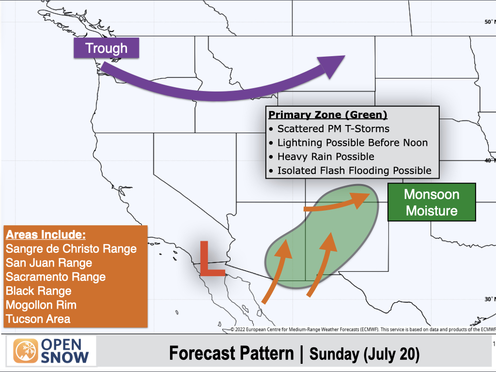
On the fringe of the monsoon, isolated to scattered thunderstorms with lighter rain amounts can be expected across Northern Arizona, Utah, and Northern and Western Colorado.
Also, Pacific moisture arriving with the Northwest trough will result in isolated to scattered thunderstorms across the Northern Rockies and portions of the Interior Northwest.
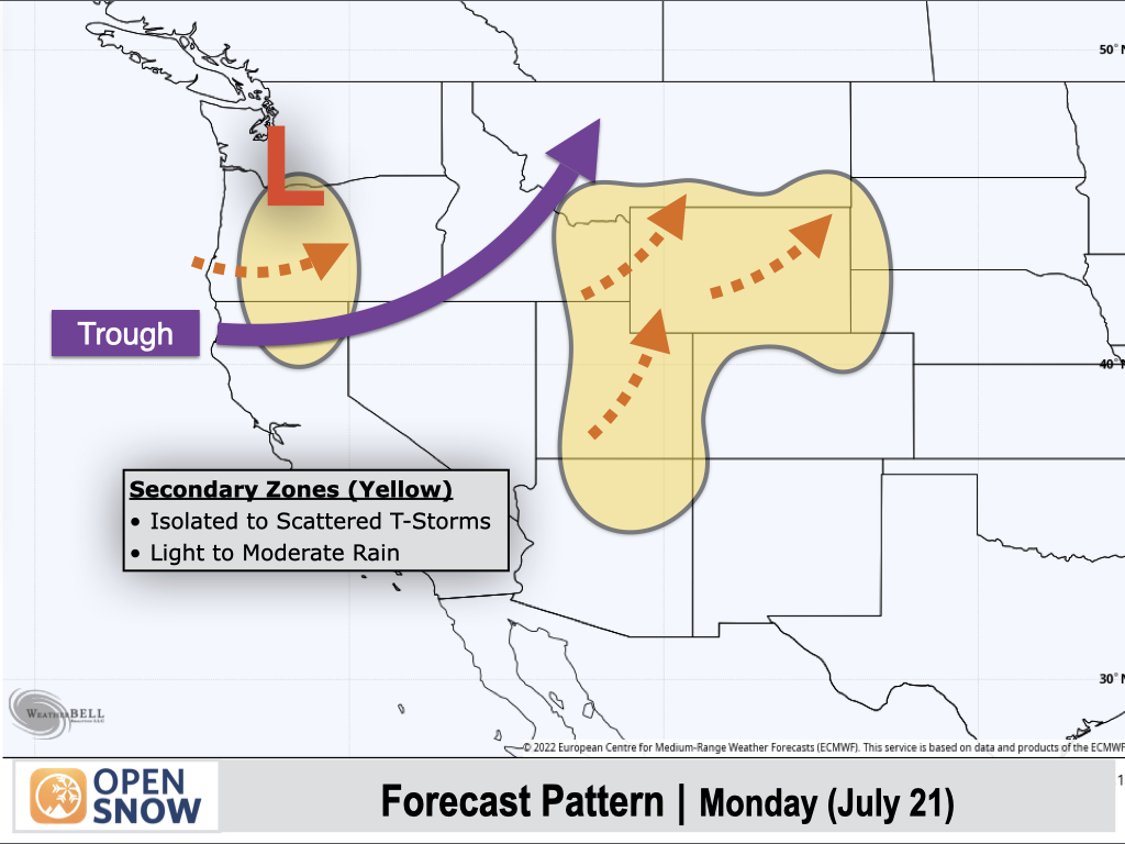
Monday (July 21):
There will be two main focus areas of active weather for Monday.
First, monsoonal moisture will expand across the Southern Rockies with thunderstorms capable of producing heavy rain across Colorado, New Mexico, and Southern and Eastern Arizona.
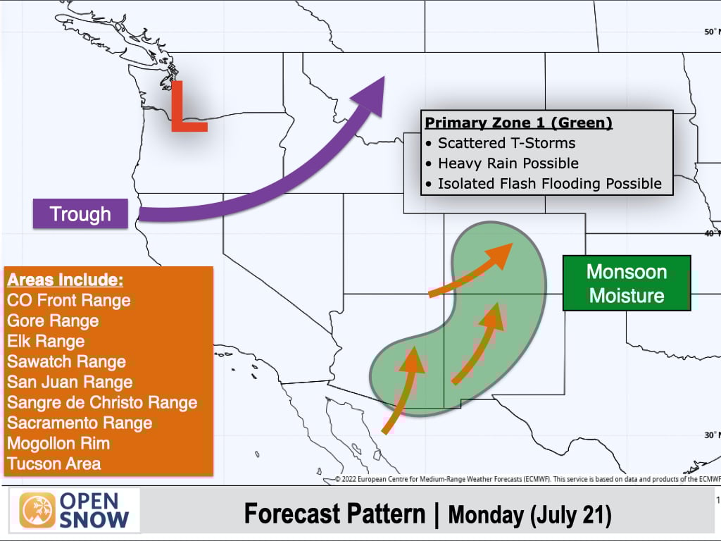
A second focus area will be over the Northwest and Northern Rockies, where yet another trough will arrive. This trough will deepen further south along the West Coast than previous troughs, with higher levels of moisture and instability arriving.
This will result in scattered to numerous terrain-driven showers and thunderstorms across the Cascades, Inland Northwest, and Northern Rockies, with locally heavy rainfall possible.
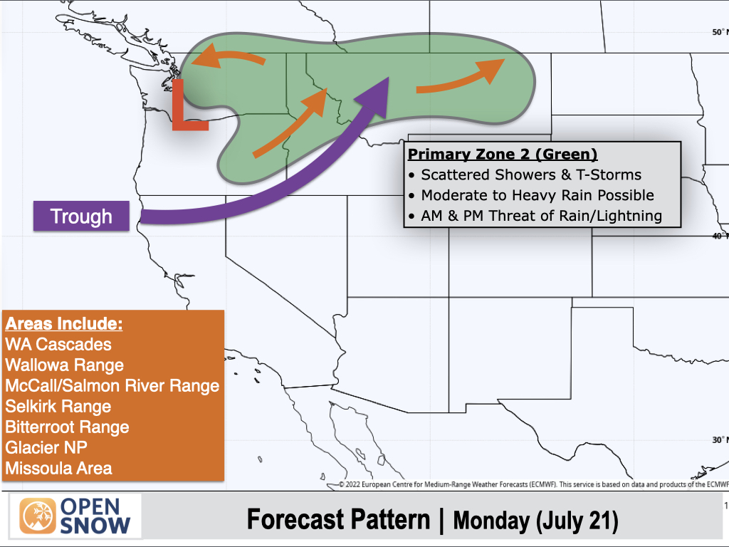
In between these two weather features, isolated to scattered thunderstorms can be expected in the yellow-shaded areas, with most storms producing light to moderate rain.
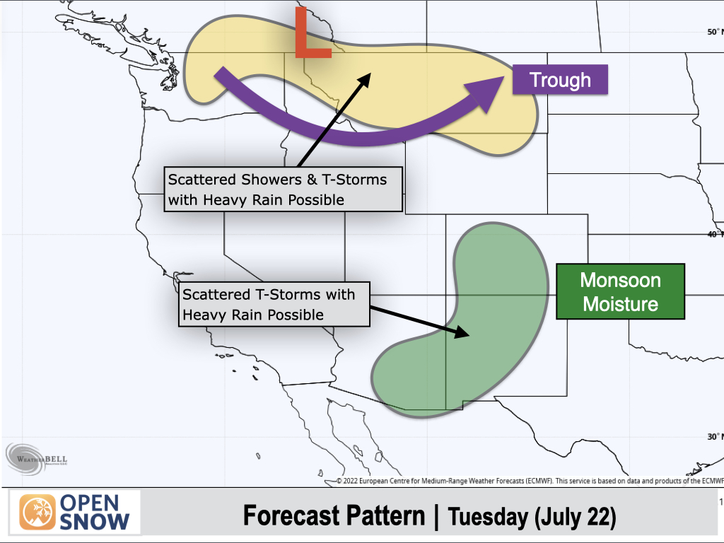
Tuesday (July 22):
The trough will continue to track across the Interior Northwest and Northern Rockies with showers and thunderstorms capable of moderate to heavy rain.
To the south, the monsoonal pattern will not change much, with Colorado, New Mexico, and Southern and Eastern Arizona remaining the most favored.
Only isolated thunderstorm activity is expected in between these two shaded areas on the map.
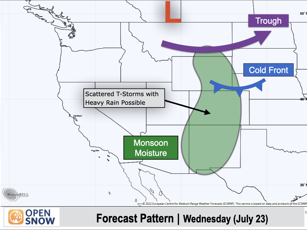
Wednesday (July 23):
As the trough continues its track eastward across the Northern Rockies, a surface cold front will slide into Eastern Wyoming with showers and thunderstorms favoring the eastern ranges of Wyoming and Southern Montana.
Monsoonal moisture will also continue to favor thunderstorms across Colorado, New Mexico, and Eastern Arizona.
To the west of the shaded area, only isolated afternoon thunderstorms are expected at most.
Extended Forecast
July 24-28:
During the second half of next week, a trough will deepen along the West Coast with a ridge of high pressure shifting well to the east of the Rockies.
The monsoon is expected to weaken in this pattern as drier air beneath the trough pushes into Arizona and Utah, with a further reduction in thunderstorm chances.
Further east, monsoonal moisture looks more favorable across New Mexico and Colorado with near-normal precipitable water (atmospheric water vapor) levels for late July. This should continue to result in daily rounds of thunderstorms across these areas.
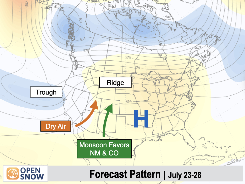
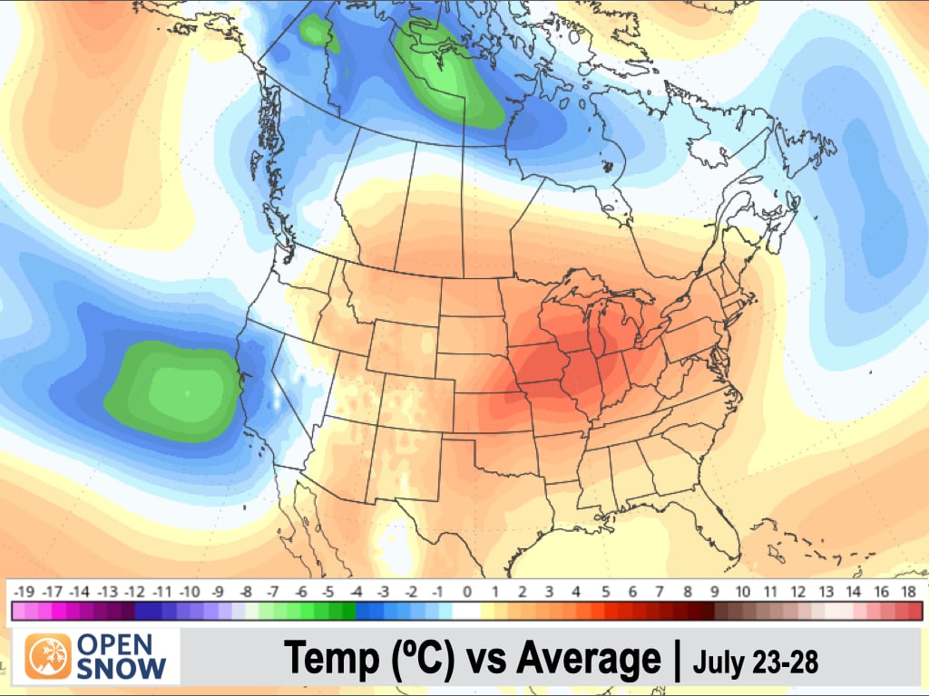
Temperatures will remain cooler than average along the West Coast, and especially over California, with well-below-normal signals showing up. To the east, the Rockies and the Southwest will start to heat back up with above-normal anomalies projected.
Late July to Early August:
During the final few days of July and into the first of August, most long-range models are projecting a high pressure ridge to build over the Eastern Rockies and High Plains with a trough just off the West Coast.
An increase in monsoonal moisture across the Southwest and the Rockies would be favored in this pattern, which could lead to an uptick in thunderstorm chances in many areas.
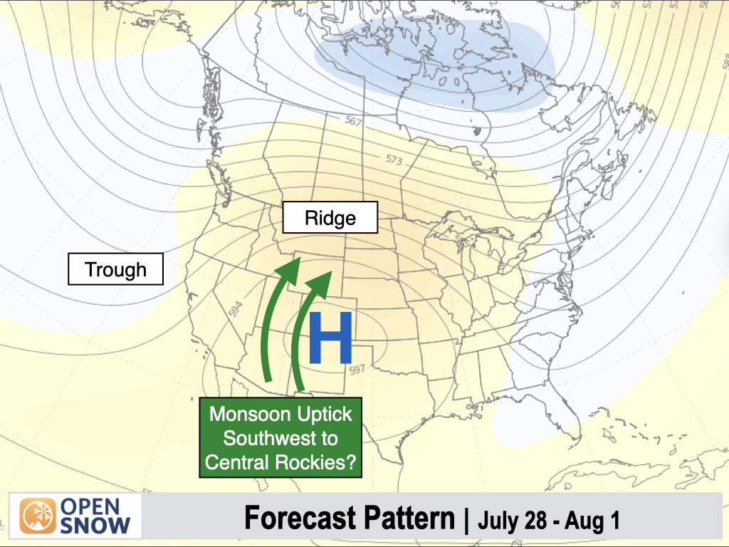
We are still 10-15 days out from this possible pattern change, so things can still change between now and then.
One longer-range model (the AI version of the European Model) is projecting a deeper trough along the West Coast and the ridge shifting further east, which would favor deeper moisture over New Mexico, Colorado, and Eastern Wyoming and less moisture further west.
But this is an outlier solution with other models (including the regular European Ensemble pictured above) projecting better moisture further west into Arizona, Utah, and Western Wyoming.
Stay tuned...
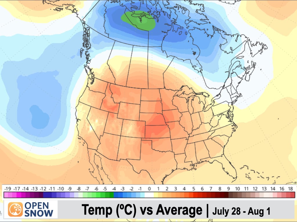
As far as temperatures, most of the West is expected to see a warm-up with above-normal anomalies, except right along the West Coast, which should warm up some but hang onto near-normal temperatures.
Depending on what happens with the monsoon, an uptick in moisture and cloud cover could potentially reduce this warming trend in some parts of the Interior West, but confidence is low this far out.
Thanks so much for reading and have a great weekend! Next update on Monday (July 21).
Alan Smith