Colorado Daily Snow

By Joel Gratz, Founding Meteorologist Posted 9 years ago March 31, 2015
Heavier snow Thursday into Friday morning
Summary:
- Sunny and warm on Tuesday
- Showers for the northern and central mtns on Wednesday
- Moderate to heavy snow for northern mtns along & east of divide on Thu
- Best chance of heavier snow on Thursday afternoon and Thursday night
- Accumulations 6-12" east of the divide, 3-6 west of the divide and along I-70
- The weekend will be dry and warmer
- Chance for one or two storms between about April 7-12th
Details:
Tuesday will be the last very warm day of the week. The sun will shine brightly through most of the day and afternoon high temperatures should push up to around 50 degrees on mid mountain. A few clouds will build during the afternoon and evening, but the lower atmosphere is very dry, so any rain or snow showers that fall out of these clouds should mostly evaporate before hitting the ground.
Wednesday will be a transition day as conditions will start warm and then a cold front will push through northern Colorado by the late afternoon and evening. This cold front will touch off showers that will be stronger than the ones on Tuesday, so many mountains in northern and central Colorado should see a dusting to an inch of snow on Wednesday afternoon through Wednesday evening. East of the divide, we might see snow become a bit steadier late Wednesday night into Thursday morning, so I put a few inches in the forecast for Cameron Pass, Rocky Mountain National Park, and Eldora.
Thursday and Thursday night is when things get more interesting. A stronger storm will push through northern and central Colorado, and temperatures will cool into the upper teens to low 20s by late Thursday night.
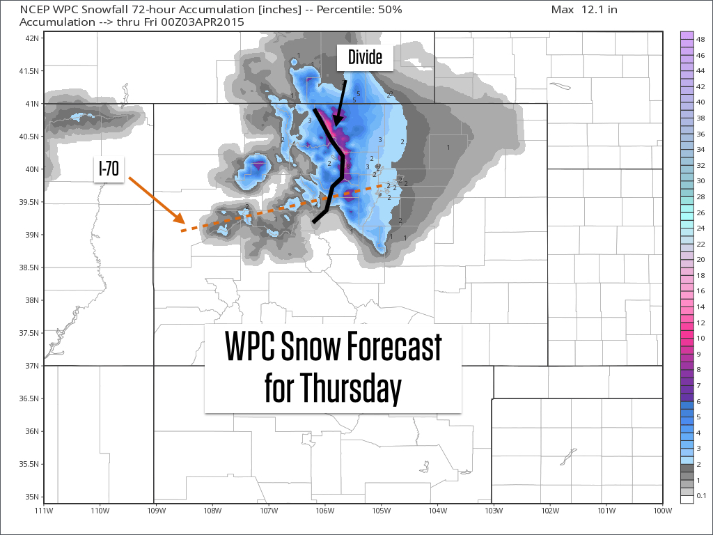
At this point, the track of this storm looks like it'll favor the areas east of the divide with 6-12 inches of snow during the day on Thursday and continuing through Thursday night. Areas along the divide might be more like 5-10 inches, with areas west of the divide and along I-70 likely falling into the 3-6 inch range. The central mountains should see less snow, perhaps around 1-3 inches, with just an inch or two in the northern San Juans.
This storm will create upslope winds east of the divide (winds from the east), while maintaining winds from the northwest for the mountains west of the divide. This is a pretty nice scenario as both sides of the divide can see decent snowfall.
The best powder east of the divide will likely be on Thursday afternoon or Friday morning. For areas west of the divide, the best powder will likely be on Friday morning. If amounts are less than 6 inches, the new snow will likely ski fine on top of the groomers but otherwise you'll probably feel the crunch. For amounts over half a foot, perhaps we'll have a fighting shot to cover up some of the crunchy base.
The map below is a mashup of forecasts from many different models and shows the 50th percentile of snow forecasts through Thursday afternoon. This means that there is a 50% chance that amounts will be lower than indicated, and a 50% chance that amounts will be more than indicated. Also, remember that more snow will fall on Thursday night, but this model mashup doesn't extend past Thursday at 6pm.
Friday will see the skies dry out, though there could be a few snow showers left over in the northern and central mountains during the morning hours.
Longer range: Next weekend will be dry and warmer, and then we'll likely see one or two storms between about April 7-12th. Yesterday I was more confident about calling for a storm on April 8th, but now there is zero agreement between the models about any of the details for next week. The models are in agreement about a colder system dropping down along the west coast early next week, but how this storm behaves after about Monday is anyone's guess. It may shoot out mini storms ahead of it, and then the main storm may eventually move east. But again, the details of this scenario are a mess, so I'll focus mainly on our upcoming Thursday/Friday storm, and when that's over I will tackle next week's outlook.
Have a great Tuesday!
JOEL GRATZ
Geography Key:
Northern Mountains
Steamboat, Granby, Beaver Creek, Vail, Ski Cooper, Copper, Breckenridge, Keystone, Loveland, Abasin, Winter Park, Berthoud Pass, Eldora, Rocky Mountain National Park, Cameron Pass
Along the Divide
Loveland, Abasin, Winter Park, Berthoud Pass
East of the Divide
Eldora, Rocky Mountain National Park, Cameron Pass
Central Mountains
Aspen, Sunlight, Monarch, Crested Butte, Irwin, Powderhorn
Southern Mountains
Telluride, Silverton, Durango, Wolf Creek (Telluride and Silverton are on the northern side of the southern mountains)
About Our Forecaster
Joel Gratz
Founding Meteorologist
Joel Gratz is the Founding Meteorologist of OpenSnow and has lived in Boulder, Colorado since 2003. Before moving to Colorado, he spent his childhood as a (not very fast) ski racer in eastern Pennsylvania.
Free OpenSnow App


