Mid-Atlantic Daily Snow

By Justin Berk, Posted 10 years ago January 17, 2014
Hope floats flakes for MLK Weekend and beyond
Summary:
A series of Alberta Clippers are swinging through, which are more beneficial to the highest terrain, and can leave the eastern resorts begging for flakes. There will be a persistent chance of snow showers, with accumulation favoring the western areas, but the first burst Friday night might pack a little more punch. Then get set for larger storms possible next week and Round 2 of the Polar Vortex
Details:
Plain and simple: It is going to snow. This is a clipper after all, so it doesn’t have a ton of moisture. But in some places like Snowshoe, all you have to do is sneeze sometimes, and a few inches will fall on the summit (it is 4848’). Here is a look at potential total accumulation from the Hi-Resolution NAM Model. This is melted equivalent. But essentially the darker shading you can expect 1-3 inches of fluffy snow to fall. The temperatures will be colder to support the drier flakes on the back end.
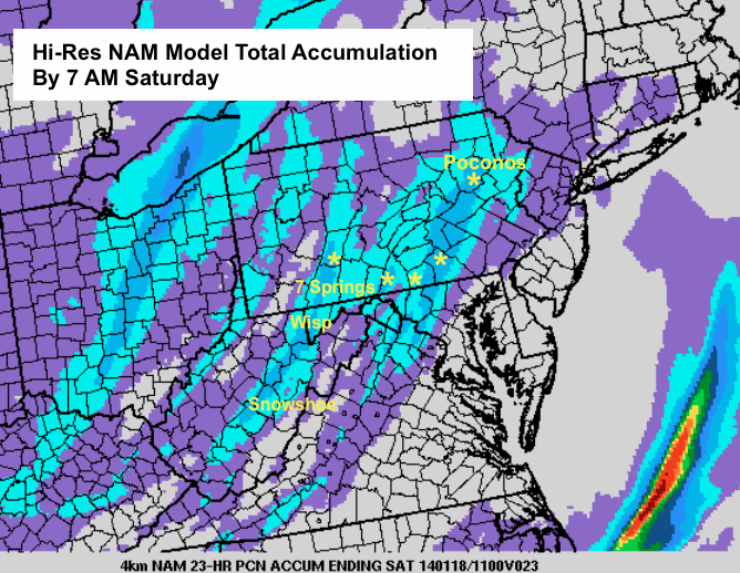
Notice that this clips most of the local ski areas up through the Poconos as well. Even a dusting or more could stick in the metro areas, which after all is what gets more people in the mood to make the drive.
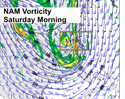
The other issue tonight will be the potential for thunder. There are two main pieces of energy in the jet stream, as seen here. This helps with lift and supports snow squalls. I think the main area could clip Wisp and 7
Springs where the higher terrain might add more lift to give enhanced action. If this happens, then forget the 1-3 inches since it could double.
There is another clipper on the way for Sunday morning. This appears to be farther south, with a direct hit on West Virginia. While Wisp could get another 1-3 inches, Timberline, Canaan Valley, and Snowshoe especially might be up for an additional 3-6 inches. This time, Wintergreen and Masanutten get in on a few inches as well.
Make sure you check out our membership privileges included snow modeling and slope cams
Long Range:
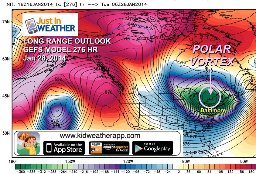
The Polar Vortex should make return to the Eastern US by the end of the month.
I have long advertised my theory of Atmospheric Memory for readers on my Facebook Page. It is a cycle or weather pattern that tends to repeat itself, especially with extreme events, and has proven itself many times over. Storms tend to follow similar paths, and can impact the same areas with the same intensity. This is also true with overall patterns in the jet stream. So after the first visit of the Polar Vortex, there was reason to believe the wobbling of the core of the coldest air would eventually work it’s way back down south to the US.
We have passed the January thaw, and the progressive pattern will be growing colder, starting next week. Despite questions of the storms next week, the trough in the jet stream will get locked over the eastern US and keep us cold. That is great for Lake Effect snow showers and man-made snow.
Here is the look at the peak of this pattern. January 28th is still over a week away, but the GEFS Ensemble mean (a the average of a bunch of model variations) points to this outlook with the Polar Vortex over northern NY State and Lake Ontario. If so, any additional snowpack on the ground would help support an even colder array of temperatures compared to the last visit. Remember last time came after a thaw. While many slopes held their snow, the surroundings east of I-81 was patchy or just plain brown.
Lot’s to look forward to in the next few weeks, but winter is far from done.
Faith-in-the-Flakes*
Also keep up to date via
Facebook: Justin Berk, Meteorologist
Twitter @JustinWeather
Instagram: justinweather
Kid Weather App
If you have a kid who loves the weather, check out my Kid Weather App that I made with my oldest son. It’s won a Parents Choice Award, been featured many times by iTunes, and even on Mashable’s Top 10 Apps to get kids interested in science. We are available for Apple and Android devices.
About Our Forecaster
Justin Berk
Free OpenSnow App


