Mid-Atlantic Daily Snow

By Justin Berk, Posted 10 years ago February 1, 2014
Summary:
Get in while the going is good this weekend
I speak for every single ski area in the Mid Atlantic when I say the conditions are epic! 100% open with a deep base and soft powder!
That said there is a little thaw underway but an active week ahead. That will be broken up into a few systems. There was a bad rumor about a monster blizzard for next weekend, but it was exaggerated and misleading. There will be a potentially large storm to cap off the active week, but nothing like a few feet of snow. So if you had heard that, please let me add to debunking the myth.
Details:
Weekend warm up
Going on the rumor mill and those faithful to the Farmer’s Almanac, there will not be a snowstorm for us this weekend. It will be mild as a storm passes to our north. So temps will reach into to 40s for many ski areas, but nothing they can’t handle. In face, it might be nice to get out and not have to bundle up.
A cold front will approach us on Sunday afternoon, so there my be some rain showers in western PA, western MD, and West Virginia, but that is time to break down for the Super Bowl anyway.
Return of the cold
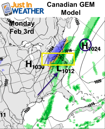
Storm #1: Monday
A cold front will arrive Sunday night, and then stall across the Mid Atlantic. This will lay down the groundwork for a wave of low pressure to ride along it. As of now it looks promising to the ski areas to bring a few inches of fresh powder, but a mix of snow and ice along the I-95 cities.
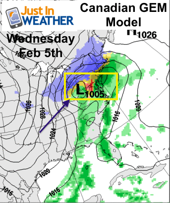
Storm #2: Wednesday
This storm has a track that will be slightly inland, meaning it will be warmer and more wet. While the onset could have snow, it will turn to ice in central PA and the Poconos. Western PA, western MD, and even West Virginia could turn to rain under the low pressure track itself. It should be noted that this is still up for debate. Any slight adjustment to the path could change this dramatically. A shift east would mean more snow, but a shift west would bring more rain. Either way, there will be an active first half of the week.
Long Range:
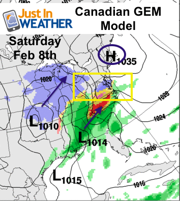
Next weekend does appear to bring a large storm to the eastern US. This is the one that was rumored to bring monster snowfall, but as you can see here the track appears to be too warm to promise that. Rather than get into details, we should prepare for another storm either spilt into two parts Saturday and Sunday, or combined into one larger event. There is still hope this does turn into a full out snow maker, but as of now, that appears to be an outside shot with an inland storm track.
So as I said earlier, get out now while the going it good.
Faith-in-the-Flakes*
Also keep up to date via
Facebook: Justin Berk, Meteorologist
Twitter @JustinWeather
Instagram: justinweather
Kid Weather App
If you have a kid who loves the weather, check out my Kid Weather App that I made with my oldest son. It’s won a Parents Choice Award, been featured many times by iTunes, and even on Mashable’s Top 10 Apps to get kids interested in science. We are available for Apple and Android devices.
About Our Forecaster
Justin Berk
Free OpenSnow App


