Colorado Daily Snow

By Joel Gratz, Founding Meteorologist Posted 9 years ago October 1, 2014
Snow on Wednesday, dry weather to follow
Summary:
Expect a wave of moderate to heavy rain and snow to move through Colorado on Wednesday with lingering snow showers on Wednesday evening (snow accumulations down to about 9,000ft). Thursday through most of next week will be dry, with the next chance for precipitation around Friday October 10th.
Details:
Yesterday was a cloudy and cool day for most of the Colorado mountains with snow showers falling during the afternoon and early evening.
After a mostly dry night, another wave of precipitation is moving into western Colorado on Wednesday morning. As of about 8am this precipitation is over the western slope and a few showers are pushing east into the higher mountains.
Wednesday 8am radar. Source: Weathertap.com
Look for bursts of moderate to heavy snow during Wednesday midday as this wave of precipitation passes through. The snow level will start off around 10,000ft, but then drop to 9,000ft during the moderate showers, and perhaps even lower during the most intense bursts of precipitation. Overall this first wave of snow should drop 2-4 inches.
There might be a lull in the precipitation late this afternoon, then additional snow showers will develop this evening from Aspen to the north and these showers will continue through about midnight. This second wave of snow should add a few more inches so by Thursday morning total accumulations will be around 4-6 inches for the northern half of Colorado and the northern San Juans, with just light amounts in the southern San Juans.
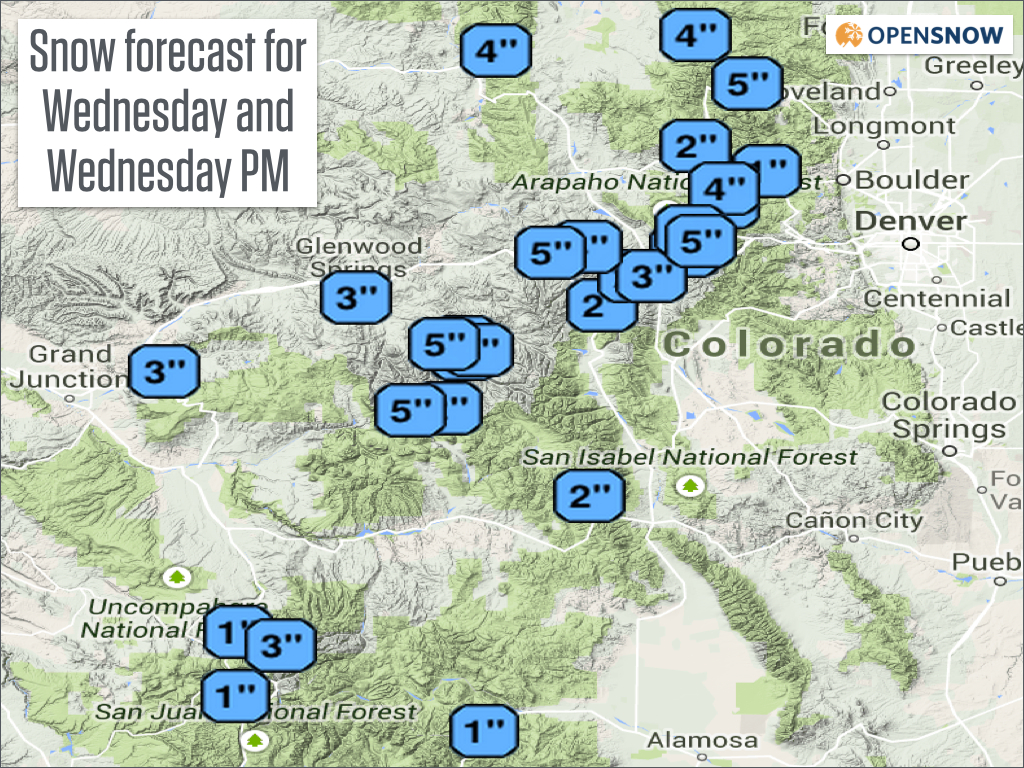
Source: OpenSnow.com map via NWS
Thursday morning will be dry with a few lingering clouds, then most areas should see full sunshine for the rest of Thursday. The weather will be dry, sunny, and tranquil from Thursday night through next Wednesday with increasing temperatures through the week. The only exception to this tranquil weather will be a few clouds and increased winds for the mountains north of I-70 on Thursday night (10/2) as a weak storm passes by to our northeast.
The next chance for precipitation will be around Friday October 10th, but this potential storm doesn't look like a big deal. There are hints of a potentially stronger storm close to the middle of the month, but 15 day forecasts are pretty unreliable, so we'll have to wait a week or so to see what transpires.
JOEL GRATZ
About Our Forecaster
Joel Gratz
Founding Meteorologist
Joel Gratz is the Founding Meteorologist of OpenSnow and has lived in Boulder, Colorado since 2003. Before moving to Colorado, he spent his childhood as a (not very fast) ski racer in eastern Pennsylvania.
Free OpenSnow App


