South America Daily Snow

By Luke Stone, Forecaster Posted 13 hours ago August 4, 2025
Storm Recap and Outlook
Summary
It was a powdery weekend across most of the Andes with lots of fresh snow. This was a much-needed storm and has improved conditions significantly across the region. Outside of some rain showers early this week, primarily in the southern part of the central zone, we should see a break in the action until later next weekend.
Short Term Forecast
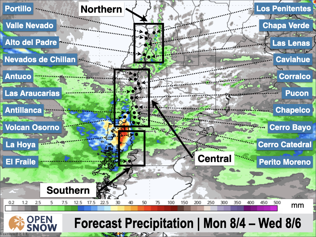
The latest storm delivered some impressive totals across the region, deepest in the northern part of the central zone and the northern zone as expected. Below are some of the storm totals:
- Corralco: 1-1.2 m (39-47 in)
- Las Lenas: 70 cm (28 in)
- Nevados de Chillan: 60 cm (24 in)
- Portillo: 56 cm (22 in)
- Valle Nevado: 50 cm (20 in)
- El Colorado: 50 cm (20 in)
- Chapelco 20 cm (8 in)
The storm performed mostly as expected, albeit in the lower end of the expected range for most. The Argentinian side of the Andes, especially in the Bariloche region, saw limited snow unfortunately. Totals at Nevados de Chillan were somewhat limited by warm air that stuck around a little bit longer than expected, but totals were likely much higher at upper elevations.
We have a weak system impacting the southern part of the central zone to start the week. Snow showers will likely transition to rain as a warm front pushes through the area on Monday night. Showers will continue on Tuesday and Tuesday night before a cold front moves through on Tuesday night that will briefly turn the showers back over to snow.
I don't expect much snow accumulation on either end of this storm, but at least the rain isn't expected to be too heavy. The worst of it is expected around Volcán Osorno and Antillanca.
We will then dry out for the rest of the week through the early part of the weekend. The models show a storm moving in around Saturday night. This has the potential to bring some decent snow totals to the region, but it's a bit too early for additional details.
Next post on Wednesday.
Thanks for reading the South America Daily Snow!
Luke Stone
Forecaster, OpenSnow
Announcements

NEW: Forecast Range Graphs

You can now view individual forecasts from global and regional high-resolution weather models in OpenSnow. This includes forecasts from the GFS, ECMWF, HRRR, and ICON models, as well as the OpenSnow blend.
The graphs give you a behind-the-scenes look at the forecast and make it easier to see if the forecast models are in tight agreement or if there is a wide range of potential outcomes over the next 10 days.
Note: This is currently only available in the OpenSnow iOS app and website (OpenSnow.com). Android will be available soon.
Getting Started
- Go to any location screen.
- Scroll down under "Weather" or "Snow Summary".
- Tap "View Interactive Chart" in the app.
- Adjust the model, timeframe, or data view.

Why is the Forecast Range helpful?
Understand if there is high or low confidence in the forecast. If all models show a similar forecast, there is higher confidence in the forecast, and vice versa.
Dig into the details. If you have experience looking at weather model data and trust certain models or higher-resolution models, you'll be able to isolate your favorite data.
View → Forecast Range Graphs
About Our Forecaster


