South America Daily Snow

By Luke Stone, Forecaster Posted 19 hours ago August 1, 2025
The Storm Is Here
Summary
Heavy snow is falling across the Andes on Friday as a strong storm tracks through the region. This will continue through Saturday before tapering to snow showers on Sunday. A break is then expected for the start of next week.
Short Term Forecast
The storm is delivering so far with healthy totals as of Friday morning. Below are a few reports:
- Corralco: 49 cm
- Farellones: 35
- Portillo: 27 cm
- La Parva: 18.5 cm
I will update this post today if any additional snow reports become available. (Updated totals from PowderQuest)
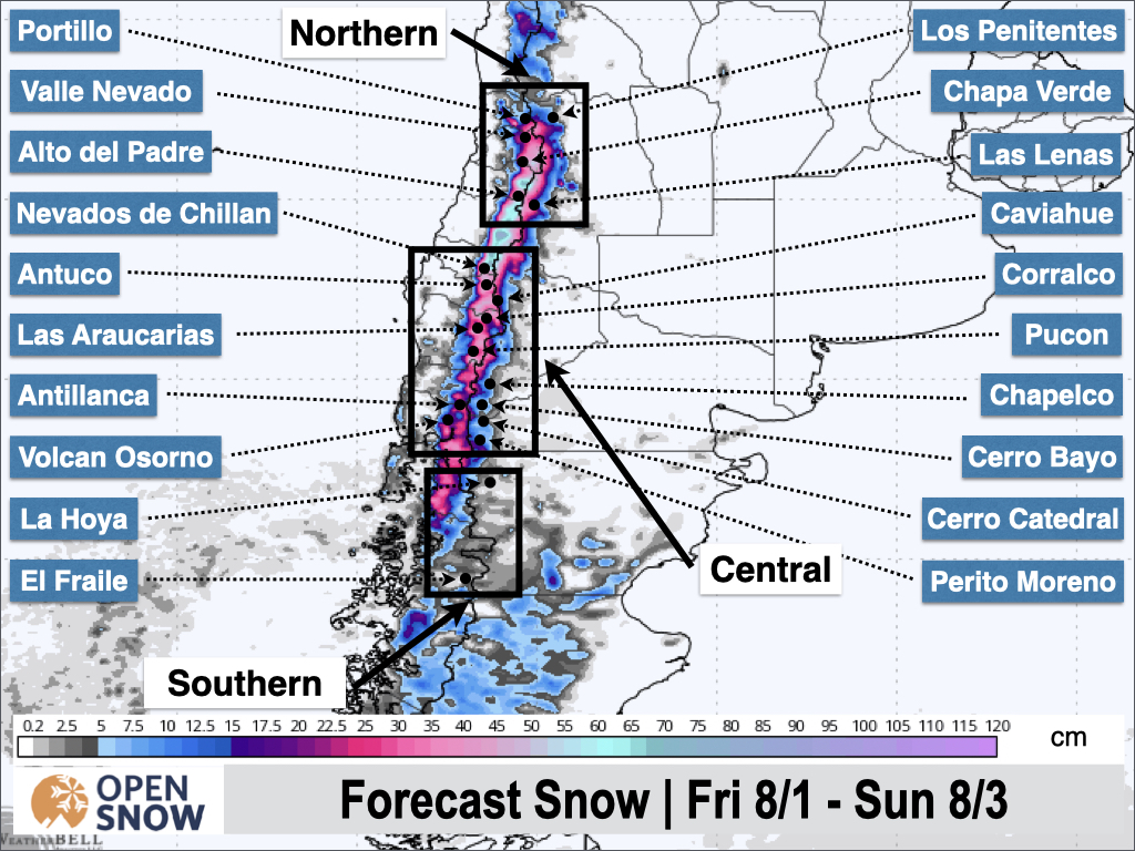
The forecast remains on track with heavy snow expected today (Friday) through Saturday morning, particularly in the north. We should see somewhat of a lull in the action on the central zone during the day on Friday, before heavy snow returns Friday night through Saturday. Most of the region should see some lingering showers through Sunday morning.
Temperatures continue to fall, and we are entering the cooler phase of the storm, which means snow quality is improving as well. Snow totals by the end of the storm on Sunday are still expected to be in the .5 to 1.5 m range for much of the Chile resorts in the central and northern zones, with much less snow expected in Argentina, especially south of Caviahue.
Below are the additional totals expected through Sunday.
We start to clear out on Sunday, and then another extended break is becoming more likely as ridging sets up over the region.
Next post on Monday.
Thanks for reading the South America Daily Snow!
Luke Stone
Forecaster, OpenSnow
Announcements

NEW: Forecast Range Graphs

You can now view individual forecasts from global and regional high-resolution weather models in OpenSnow. This includes forecasts from the GFS, ECMWF, HRRR, and ICON models, as well as the OpenSnow blend.
The graphs give you a behind-the-scenes look at the forecast and make it easier to see if the forecast models are in tight agreement or if there is a wide range of potential outcomes over the next 10 days.
Note: This is currently only available in the OpenSnow iOS app and website (OpenSnow.com). Android will be available soon.
Getting Started
- Go to any location screen.
- Scroll down under "Weather" or "Snow Summary".
- Tap "View Interactive Chart" in the app.
- Adjust the model, timeframe, or data view.

Why is the Forecast Range helpful?
Understand if there is high or low confidence in the forecast. If all models show a similar forecast, there is higher confidence in the forecast, and vice versa.
Dig into the details. If you have experience looking at weather model data and trust certain models or higher-resolution models, you'll be able to isolate your favorite data.
View → Forecast Range Graphs
About Our Forecaster


