South America Daily Snow

By Luke Stone, Forecaster Posted 1 day ago July 30, 2025
A Big Dump Is Finally Coming
Summary
After a rainy start to the week for parts of the Andes, a significant snowfall event is expected from Wedneaday through Sunday. The Chilean resorts in the northern and central zones should do best, with much lower totals south and east in the Argentinian Andes. Things should quiet down next week after this storm.
Short Term Forecast
Models are in good agreement ahead of a strong and cold storm that will bring significant snow to the Andes this week. A strong atmospheric river combined with an impressive cold front will produce the biggest storm the region has seen in over a month.
We have been talking about this storm for a while now, and it finally looks like we're going to get some legit powder days. The atmospheric river responsible for the rain in the central zone over the past few days will pivot north as the upper-level low comes ashore along with a cold front.
This will result in a period of very heavy snow, especially in the northern zone and the northern part of the central zone. The heaviest snow is generally expected between Wednesday night and Saturday morning, though some locations will see heavy snow before and after this window. Moderate to heavy snow is expected to continue through Saturday night/Sunday morning in the northern part of the central zone.
Winds will be strong, especially Wedneaday and Wednesday night in the central zone, and will remain gusty through much of the event. Once the cold front moves through on Friday, snow-to-liquid ratios will be high, resulting in some really nice low-density snow.
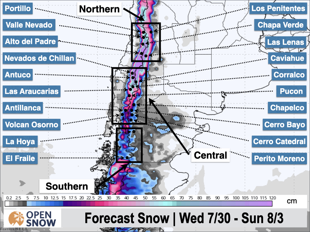
The central and northern zones will see significant accumulations, generally in the .6 to 1.2 m range. This includes areas like Valle Nevado, Portillo, and Las Lenas in the northern zone, as well as Corralco and Antuco in the central zone. At Nevados de Chillan, where the snow is expected to linger the longest, totals could exceed 1.5 m by Sunday night.
Below is the latest snow forecast from the European ensemble.
The best powder days for most of the region will be Friday, Saturday, and Sunday. Friday and Saturday should feature fresh snow with refills during the day, but limited visibility. On Sunday, there will be some additional fresh snow in the morning in the northern part of the central zone, while most of the region sees skies start to clear. This should allow for further exploration into different zones with better visibility.
Extended Forecast
We should see a break in the action from Sunday through Monday before a weaker storm impacts the region from Monday night through the middle of next week. Most models limit the impacts from this storm to light rain and snow, but there are some indications that this could be a more significant storm, so we'll have to keep a close eye on it.
Next post on Friday.
Thanks for reading the South America Daily Snow!
Luke Stone
Forecaster, OpenSnow
Announcements

NEW: Forecast Range Graphs

You can now view individual forecasts from global and regional high-resolution weather models in OpenSnow. This includes forecasts from the GFS, ECMWF, HRRR, and ICON models, as well as the OpenSnow blend.
The graphs give you a behind-the-scenes look at the forecast and make it easier to see if the forecast models are in tight agreement or if there is a wide range of potential outcomes over the next 10 days.
Note: This is currently only available in the OpenSnow iOS app and website (OpenSnow.com). Android will be available soon.
Getting Started
- Go to any location screen.
- Scroll down under "Weather" or "Snow Summary".
- Tap "View Interactive Chart" in the app.
- Adjust the model, timeframe, or data view.

Why is the Forecast Range helpful?
Understand if there is high or low confidence in the forecast. If all models show a similar forecast, there is higher confidence in the forecast, and vice versa.
Dig into the details. If you have experience looking at weather model data and trust certain models or higher-resolution models, you'll be able to isolate your favorite data.
View → Forecast Range Graphs
About Our Forecaster


