South America Daily Snow

By Luke Stone, Forecaster Posted 1 day ago July 28, 2025
Going for a Ride on the Weather Rollercoaster
Summary
After a return to snow for much of the central zone on Friday and Saturday, and then the northern zone Sunday through Monday, we enter a warmer period that will feature heavy rain and strong winds for much of the area. We will transition back to snow starting on Wednesday, and the trajectory of the atmospheric river may limit the rainfall farther north.
Short Term Forecast
Corralco continued to receive snow later in the week with 56 cm through Sunday, while Cerro Catedral saw 50 cm. After some nice fresh snow, however, with the atmospheric river moving into the region, we'll see temperatures rise and periods of rain. The models have trended a bit farther south with this atmospheric river, which should limit the heaviest rain to the southern zone and the southern half of the central zone.
Last week's model runs had this extending through the northern part of the central zone into Corralco and Nevados de Chillan, so this is a positive development. Still, a significant amount of rain is expected where the atmospheric river sets up.
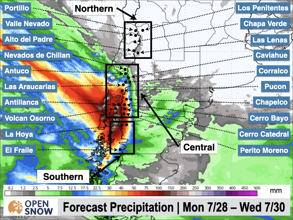
Once the upper-level system moves into the Andes Tuesday night through Wednesday, we'll see the rain transition to snow in the central zone, with snow also picking up in the northern zone. The upper-level low will push a cold front across the Andes, and snow levels will fall back below base elevations between Wednesday night and Thursday night.
Moderate to heavy snow is possible from Wednesday night through Friday in the central and northern zones. There is the possibility that it could continue in the parts of the central zone, with significant additional accumulations between Friday night and Sunday. Below is the latest snow forecast from the European ensemble.
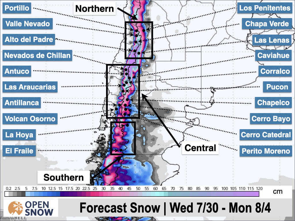
Once again, there is a lot of potential here, but given the recent trend for the models to back off on snow totals as we get closer to the potential event, I am cautiously optimistic at this time. Many areas could see .5 to 1 m from this phase of the storm, but I will hold off until Wednesday for the final snow forecast.
Extended Forecast
The long-range models keep hope alive with another possible storm starting next Monday. This is definitely something to watch following this snow later this week.
Next post on Wednesday.
Thanks for reading the South America Daily Snow!
Luke Stone
Forecaster, OpenSnow
Announcements

NEW: Forecast Range Graphs

You can now view individual forecasts from global and regional high-resolution weather models in OpenSnow. This includes forecasts from the GFS, ECMWF, HRRR, and ICON models, as well as the OpenSnow blend.
The graphs give you a behind-the-scenes look at the forecast and make it easier to see if the forecast models are in tight agreement or if there is a wide range of potential outcomes over the next 10 days.
Note: This is currently only available in the OpenSnow iOS app and website (OpenSnow.com). Android will be available soon.
Getting Started
- Go to any location screen.
- Scroll down under "Weather" or "Snow Summary".
- Tap "View Interactive Chart" in the app.
- Adjust the model, timeframe, or data view.

Why is the Forecast Range helpful?
Understand if there is high or low confidence in the forecast. If all models show a similar forecast, there is higher confidence in the forecast, and vice versa.
Dig into the details. If you have experience looking at weather model data and trust certain models or higher-resolution models, you'll be able to isolate your favorite data.
View → Forecast Range Graphs
About Our Forecaster


