US & Canada Daily Snow

By Joel Gratz, Founding Meteorologist Posted 6 years ago November 12, 2018
What mountains get snow through Thanksgiving?
Summary
In the west, Colorado and western Canada will be the lone areas to receive significant snow, while the northeast racks up two additional major storms. Starting around Thanksgiving, the pattern may begin to change with snow and cold returning to the west.
Short Term Forecast
Powder
On Sunday, November 11, a storm moved through Colorado with the deepest snow falling in Colorado’s eastern mountains. Eldora Mountain, about 30 miles as the crow flies west of Denver, received 6-10 inches. This scene looks like full-on winter skiing, and it’s only early November:-)

Forecast for this week
The storm track will keep most of the western US dry (once the storm moves away from Colorado on Monday morning).
The western Canada provinces of British Columbia and Alberta will be hit with a midweek storm, and the northeastern US will see two storms with the potential for 10+ inches of snowfall.
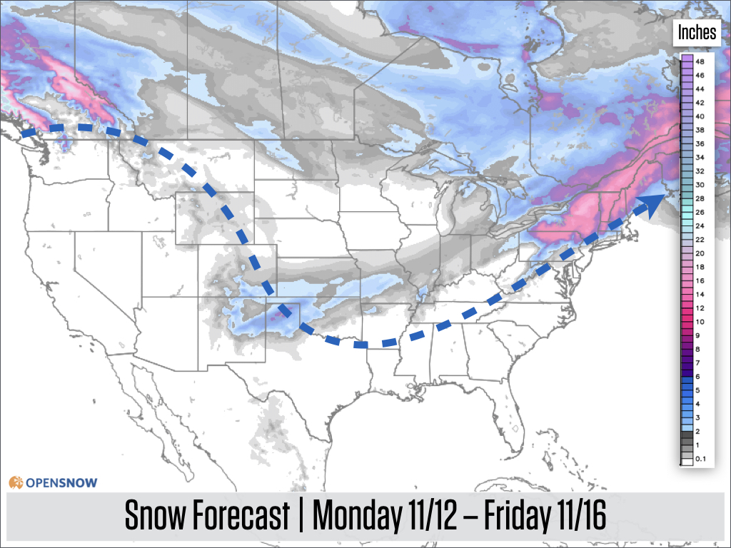
The two storms over the northeast will be similar to the previous two systems with a mix of snow, sleet, freezing rain, and rain depending on the elevation and latitude (north vs south) of the resort.
The first storm over the northeast will hit on Tuesday, November 13th. Most mountains in the northern half of New England will see a mix or mostly snow.

The second storm over the northeast will hit on Friday, November 16th. This storm may take a slightly more southerly track, which means more mountains could see snow instead of a mix or rain.

In the wake of each storm that moves through the northeast, temperatures will cool which will create fantastic conditions for snowmaking.
Forecast for the weekend
The weather pattern will remain mostly unchanged into the weekend, with the focus for cold air and light-to-moderate snow over the Great Lakes and New England.

Extended Forecast
When looking out to the week of Thanksgiving, there are two things that interest me in the forecast map below.

First is that the cold air should hang around New England, which likely means that good snowmaking conditions should continue.
Second, the blob of colder air over the Pacific Ocean, near California, shows that storminess might finally push into the western US, bringing lower-elevation rain to California (which would be a welcome relief from the fires though could introduce the risk of mudslides) as well as mountain snow to much of the west.
If we do see this change in the weather pattern, it would mean that snow would return to the western United States starting around or just after Thanksgiving, and the stormier pattern might continue for the west through early December.
Thanks for reading and look for the next forecast on Thursday, November 15.
JOEL GRATZ
Announcements
Find your local forecast → https://opensnow.com/forecasts
Download our free mobile app → https://opensnow.com/about/app
About Our Forecaster


