Western US Daily Snow

By Alan Smith, Meteorologist Posted 11 months ago August 14, 2024
Unsettled Pattern Northern Rockies, Drying Trend Central/Southern Rockies
Summary
Following a wet start to the week, drier air will work its way into Utah and Colorado and the Southwest U.S. on Wed-Thu, leading to a break in the thunderstorm pattern. The Interior NW and Northern Rockies will remain unsettled with showers & t-storms as a series of disturbances move through. The Cascades/PNW could potentially see some welcome moisture this weekend but confidence is low.
Short Term Forecast
Big Picture Weather Pattern:
A trough of low pressure from early this week will depart onto the Northern Plains mid-week and a cold front will move from north to south across the Rockies, resulting in comfortable mid-week temps. Moisture will linger across Colorado on Wednesday, but drier air will spread in from the west by Thursday, drying out the entire Four Corners region.
Another trough will move into the Pacific Northwest on Wednesday-Thursday and will act as a trigger for showers and thunderstorms across the Interior NW and Northern Rockies where the atmosphere will be unstable. Temperatures will also be on the cooler side of average in this region.

5-Day Temperature Forecast:
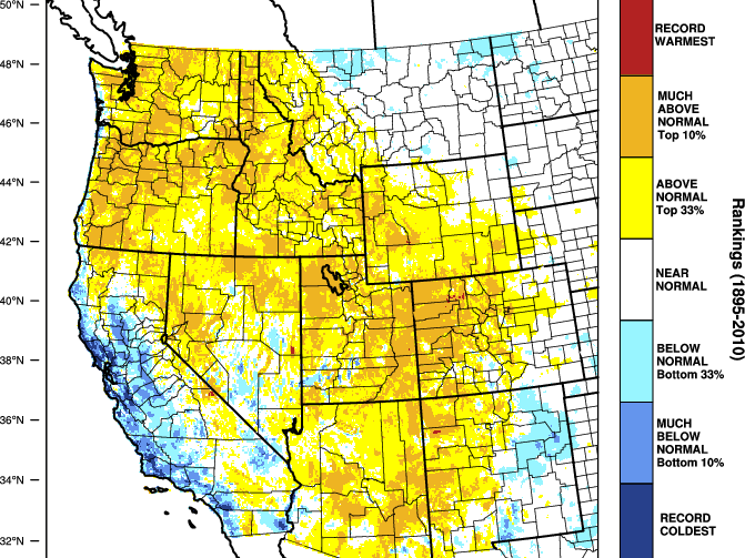
Below-average temperatures will prevail near the West Coast during this period, especially in Oregon and Northern California. The Rockies will start this period on the cooler side with a warming trend over time. Five-day anomalies will be close to average over the Northern and Central Rockies, while New Mexico and Arizona will be above average.

Fire and Smoke Outlook:
Wildfire smoke from PNW fires will shift a bit southward into Southern Montana and Northern Wyoming on Wednesday in the wake of a cold front, while much of Central Idaho will also remain smoky.
High-Res Smoke (Sky) Forecast for 5pm Wednesday:

On Thursday, smoke should start to lift northward again into Northern Idaho and Northern Montana.
Looking further out, there is a chance that consistent cooler temperatures and higher relative humidity values across parts of the Northwest may help to reduce overall fire intensity and smoke transport compared to recent weeks, but no guarantees as smoke forecasts are tough to nail down more than a few days out.
Rain and Thunderstorm Forecast for Wed (Aug 14) to Thu (Aug 15):
The heavy rain and flash flooding threat from recent days will taper off during this period, but the pattern will remain unsettled across the Interior Northwest and Northern and Central Rockies with scattered showers and thunderstorms expected.

Colorado:
On Wednesday, scattered thunderstorms can be expected across northwestern portions of the state from the Grand Mesa and Elks to the Park Range, with more isolated activity elsewhere. Moisture will further decrease on Thursday with only isolated short-lived storms over some of the higher peaks across the state.

Northern Rockies:
On Wednesday, lingering moisture will continue to result in scattered showers and thunderstorms across Wyoming, Eastern Idaho, and Southwest Montana. On Thursday, Central Idaho and Western Montana will see an uptick in thunderstorms with isolated to scattered activity across Western Wyoming.

Granite Peak, the highest point in the Beartooth Range and in the state of Montana, will see inclement weather on Wednesday and Thursday.
There is a high likelihood of thunderstorms on both days, and snow is also expected near the summit on Wednesday. We are forecasting snow levels to dip to 12,000 feet on Wednesday with light accumulations possible on the summit.

Pacific Northwest:
Showers and thunderstorms will also favor portions of Central and Eastern Oregon on Wednesday night and Thursday, mainly from the east side of the Cascades to the Wallowas. In Washington, shower and thunderstorm activity will be more isolated over the Cascades and Eastern Olympics.

Forecast for Fri (Aug 16) to Sat (Aug 17):
Scattered thunderstorms can be expected over the Northern Rockies again on Friday while the Four Corners region will stay mostly dry other than some very isolated activity.
On Saturday, the pattern turns more interesting as a strong trough of low pressure approaches the PNW. Some models (such as the one pictured below) are projecting significant moisture for the Cascades and coastal ranges in Washington and Oregon, while others are projecting much drier conditions. Confidence is low at this time.
Monsoonal moisture will also return to Arizona and Utah on Saturday with scattered thunderstorms expected, though rainfall amounts look to be on the lighter side initially.

Forecast for Sun (Aug 18) to Mon (Aug 19):
Monsoonal moisture will continue to spread northward and eastward across the Rockies with scattered thunderstorms expected. The Washington Cascades could also hang onto some shower chances.

Extended Forecast
Outlook for Tue (Aug 20) to Sat (Aug 24):
Temperatures will remain on the cooler side of average near the West Coast, while the Rockies and Southwest will continue to trend warmer.
Routine thunderstorm chances will continue across the Rockies with monsoonal moisture in place, while the Cascades could see occasional showers as disturbances track through the area.

Thanks so much for reading! Next update on Friday (August 16).
Alan Smith
About Our Forecaster


