Western US Daily Snow

By Alan Smith, Meteorologist Posted 6 hours ago August 6, 2025
Dry Pattern for Much of the West Through the Weekend
Summary
A trough moving across the Northern Rockies will bring rain to Northern Idaho & Montana on Thursday, then the pattern will dry out for most of the West with only limited pockets of appreciable thunderstorm chances through the weekend. Wildfire smoke will continue to plague the Southwest as well. Next week, the monsoon looks to pick up somewhat, but confidence in the details is low.
Short Term Forecast
Helpful Links:
Wildfire and Smoke Update:
Numerous large wildfires are burning across the West this week, with the highest concentration over the Southwest, where conditions have been abnormally dry.
The map below shows active wildfires across the West with updated acreage as of August 5th in most cases (acreage may have increased on some of the fires since then).
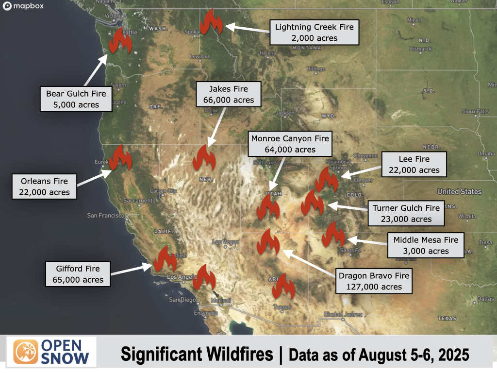
Smoke from these fires will continue to impact portions of the Southwest and Southern Rockies over the coming days, including Colorado, which is located directly downwind of some of the larger fires.
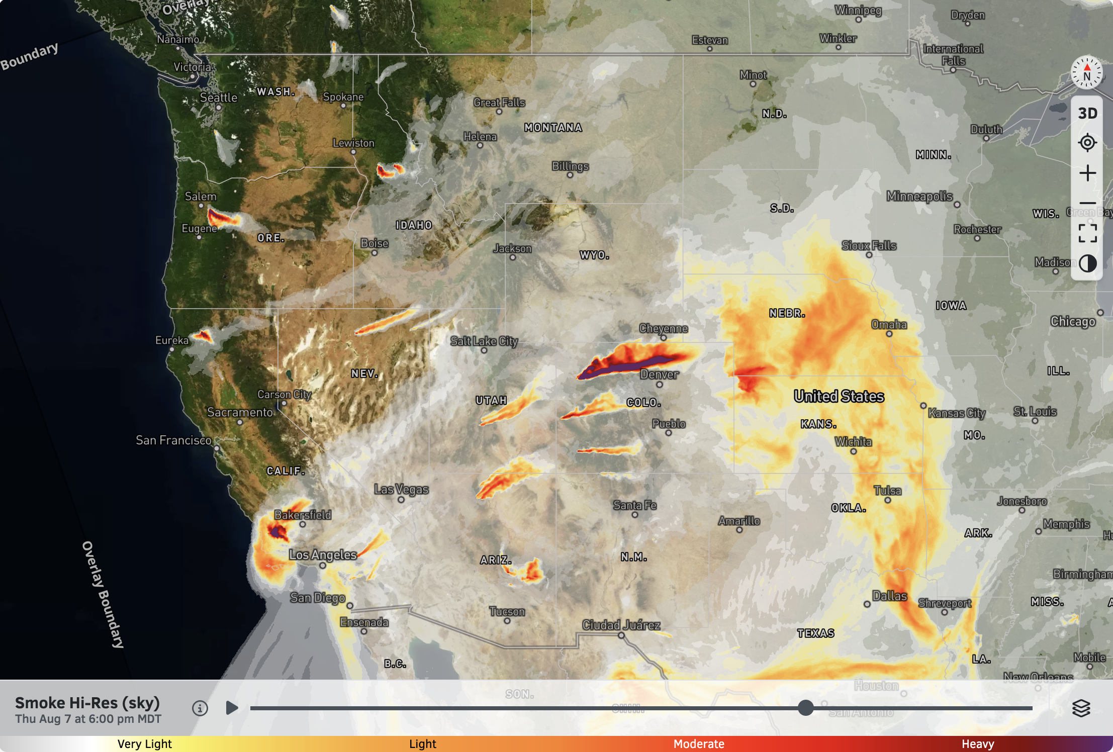
Smoke (sky) forecast for 6 PM Thursday:
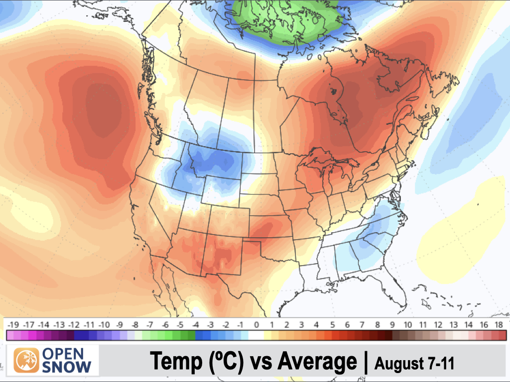
5-Day Temperature Outlook:
Temperatures will be below normal over the Northern Rockies as a strong cold front moves through on Thursday-Friday, while the Southwest will be above normal.
Temperatures will also creep up to above-normal levels along the West Coast as a ridge of high pressure builds over the area, following an extended period of near to below-normal temperatures.
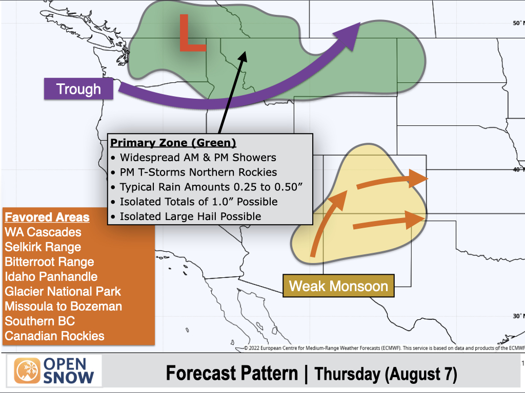
Thursday (Aug 7):
A powerful trough will move across the Northern Rockies after bringing significant rain to Western Washington on Wednesday.
Rain showers can be expected across the Interior Northwest and Northern Rockies during the AM and PM hours on Thursday, with thunderstorms also possible in the afternoon, mainly from Eastern Washington to Montana.
Rainfall amounts across the Inland Northwest and Northern Rockies will generally range from a quarter inch to a half-inch, but isolated higher totals of one inch or more are possible with stronger thunderstorms.
There is also a risk of strong to severe thunderstorms across Montana during the afternoon, with the strongest storms capable of producing one-inch diameter hail and wind gusts of 60 mph or higher.
To the south, a weak monsoon pattern will be in place with isolated afternoon thunderstorms over Colorado, New Mexico, and Eastern Arizona. Any storms that develop in this region will produce light rain and gusty winds.
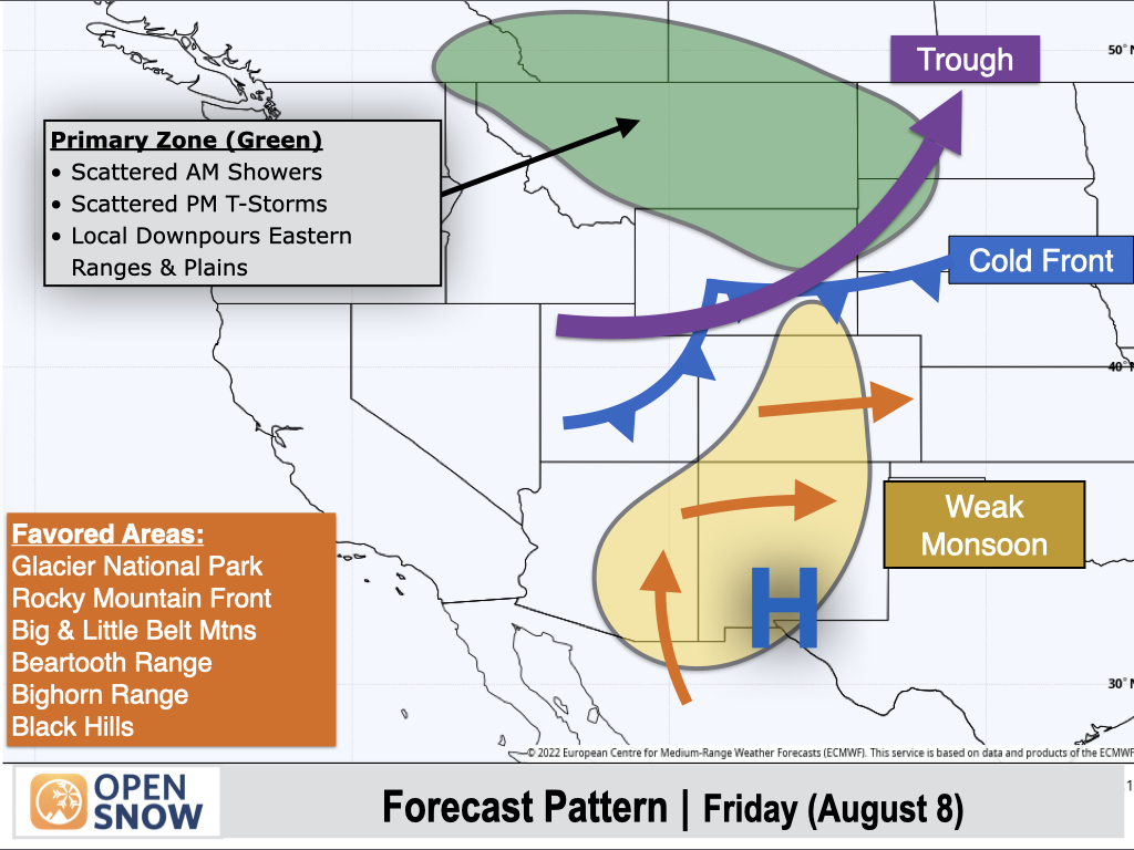
Friday (Aug 8):
The trough will begin to push eastward from the Northern Rockies on Friday as a cold front pushes through. Lingering moisture will support a threat of isolated to scattered showers in the morning, followed by a chance of thunderstorms in the afternoon.
Rainfall amounts across the Northern Rockies will generally be lighter and more spotty compared to Thursday, but localized downpours are possible with afternoon thunderstorms over the easternmost mountain ranges and adjacent plains.
A weak monsoon pattern will remain in place over Colorado, New Mexico, and Eastern Arizona with isolated terrain-driven thunderstorms expected. Once again, any storms in this region will produce light rain and gusty winds.
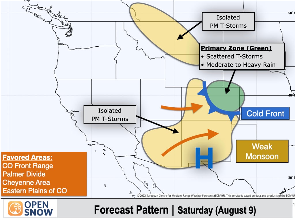
Saturday (Aug 9):
A cold front will slide into Northeast Colorado, with increasing moisture along the eastern slopes of the Continental Divide supporting a threat of scattered thunderstorms, mainly along the Front Range of Colorado. Stronger storms will be capable of producing moderate to heavy rain.
West of the Continental Divide, and further south ahead of the cold front across Southern Colorado, New Mexico, and Arizona, thunderstorm activity will be more isolated with only light and spotty rainfall expected.
To the north, lingering moisture will also result in isolated afternoon thunderstorms across the eastern ranges of Montana and Northern Wyoming.
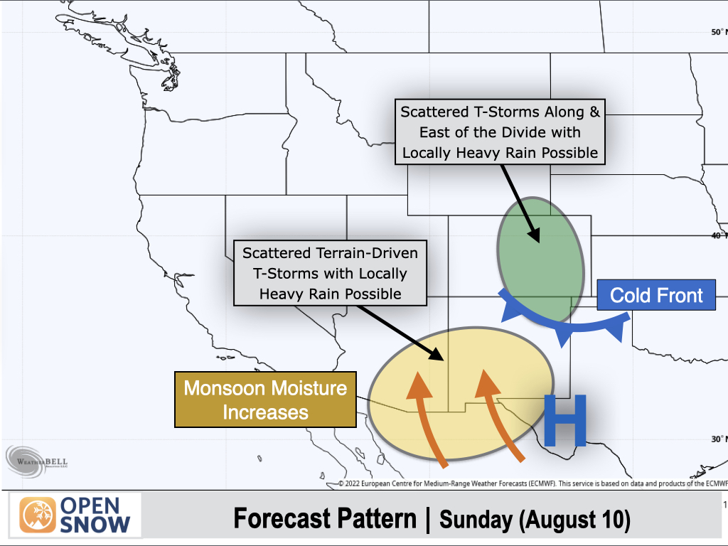
Sunday (Aug 10):
The cold front will slide into Northern New Mexico, with easterly upslope winds and moisture behind the front supporting a scattered afternoon thunderstorm setup along and east of the Continental Divide in Colorado and Northern New Mexico. Stronger thunderstorms will be capable of producing locally heavy downpours.
Areas west of the Divide in Colorado will only see some isolated thunderstorm activity with light and spotty rainfall.
To the south, monsoonal moisture will increase across southern portions of Arizona and New Mexico. This will result in a relative uptick in thunderstorm coverage, with stronger storms capable of producing locally heavy rain.
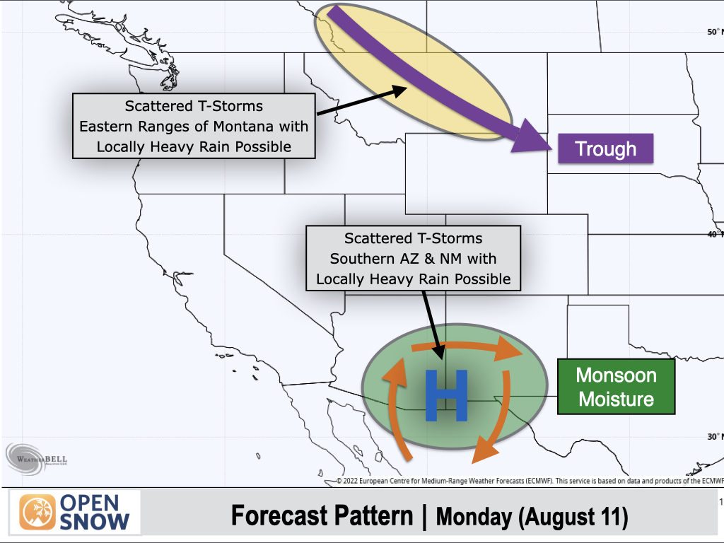
Monday (Aug 11):
Monsoon moisture will continue to increase across Southern Arizona and New Mexico, resulting in scattered thunderstorms with locally heavy rain possible.
To the north, a shortwave trough will slide into the Canadian Rockies and Montana from the northwest, resulting in scattered afternoon thunderstorms, mainly along and east of the Continental Divide.
Extended Forecast
August 12-16:
A ridge of high pressure will build near the West Coast, while emerging signals indicate a somewhat stronger monsoon pattern setting up over the Southwest (compared to recent weeks anyways).
There is still some uncertainty regarding the strength and location of the primary monsoon circulation, but there are some hints of moisture increasing over the western monsoon region of Arizona, Utah, and possibly Wyoming, with tropical activity in the Eastern Pacific playing a role.
On the eastern periphery of the high pressure ridge near the West Coast, Pacific disturbances are expected to slide into Montana from the northwest, resulting in additional shower and thunderstorm chances.
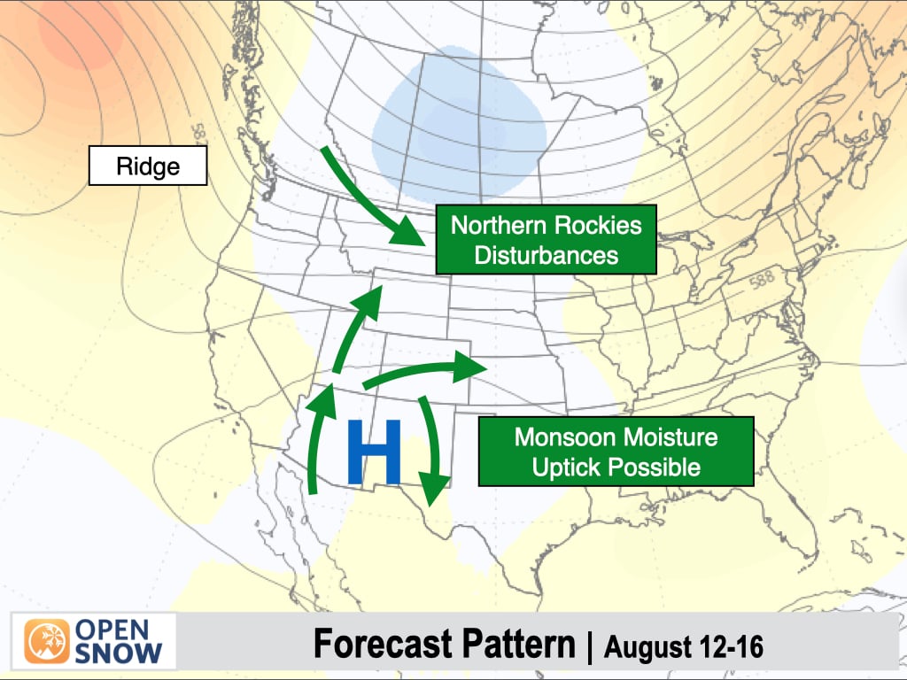
Temperatures are expected to be above normal along the West Coast and across the Southwest, with the potential for below normal temperatures over the Northern Rockies.
However, there is still some uncertainty in the temperature outlook depending on the strength and eastward/inland extent of the high-pressure ridge over the West Coast.
![]()
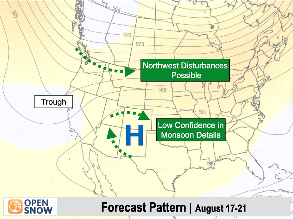
August 17-21:
The monsoon is expected to continue across the Southwest during this period, but models are in poor agreement regarding the strength and coverage of the monsoon.
Some models are focusing monsoonal moisture further west over Arizona and Utah, while others are focusing the moisture further east over Colorado and New Mexico.
To the north, there are some hints of Pacific disturbances tracking across Washington, Northern Idaho, and Montana, with occasional showers and thunderstorms possible.
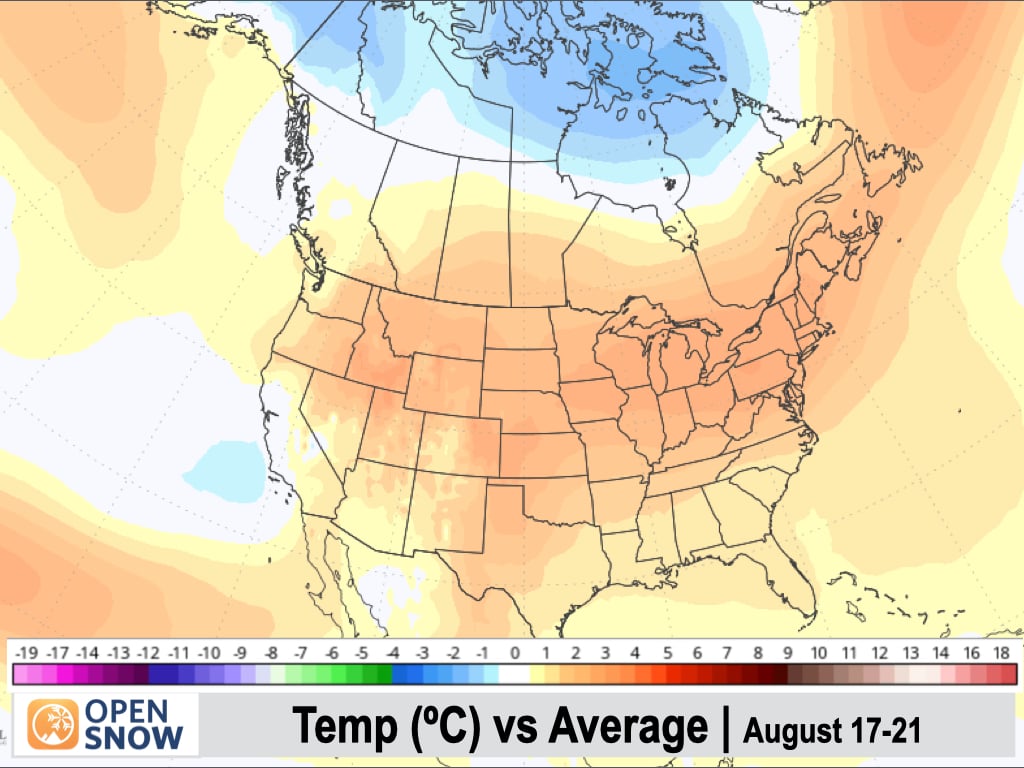
Temperatures are generally expected to be above-normal across most of the West, though some cooling is possible along the West Coast, especially in California.
Thanks so much for reading! Next update on Friday (August 8).
Alan Smith
About Our Forecaster


