News

By Joel Gratz, Founding Meteorologist Posted 9 years ago October 21, 2015
OpenSnow Winter Ski Forecast for 2015/2016
For the first time, skiers and snowboarders in the US can view a long-range forecast that answers their most pressing question: How much snow will my favorite ski areas receive this winter?
While NOAA and other forecast services produce winter outlooks that focus on temperature, precipitation, and snowfall trends across the United States, no organization (that we know of!) has taken on the challenge of making a long-range snowfall forecast specifically for ski areas.
Producing a winter forecast in October means that we’re making a six-month forecast, extending from November through April. Even the best meteorologists cannot produce perfect six-month forecasts year-after-year, but we are giving it a shot and are encouraged by our results.
On average, for our winter snow forecasts made in early October, we will get the forecast right about 2/3rds of the time. This level of accuracy can certainly help skiers and riders gain insight into which ski areas could see above average or below average snowfall this winter.
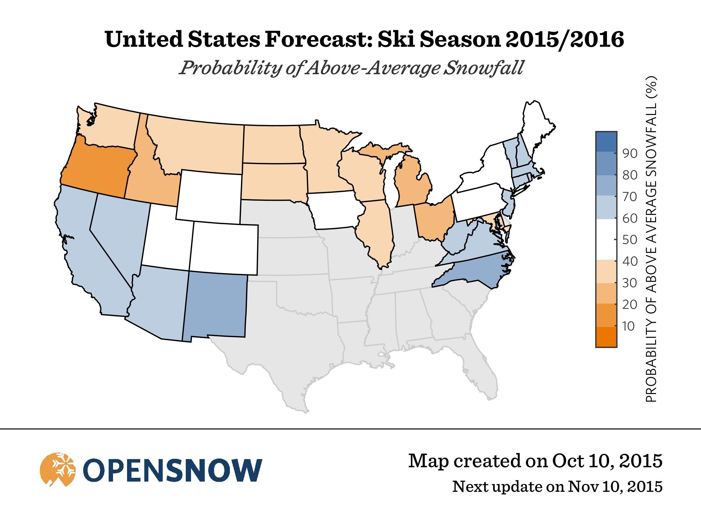
Here is our snowfall forecast for this winter, 2015-2016, averaged by state.
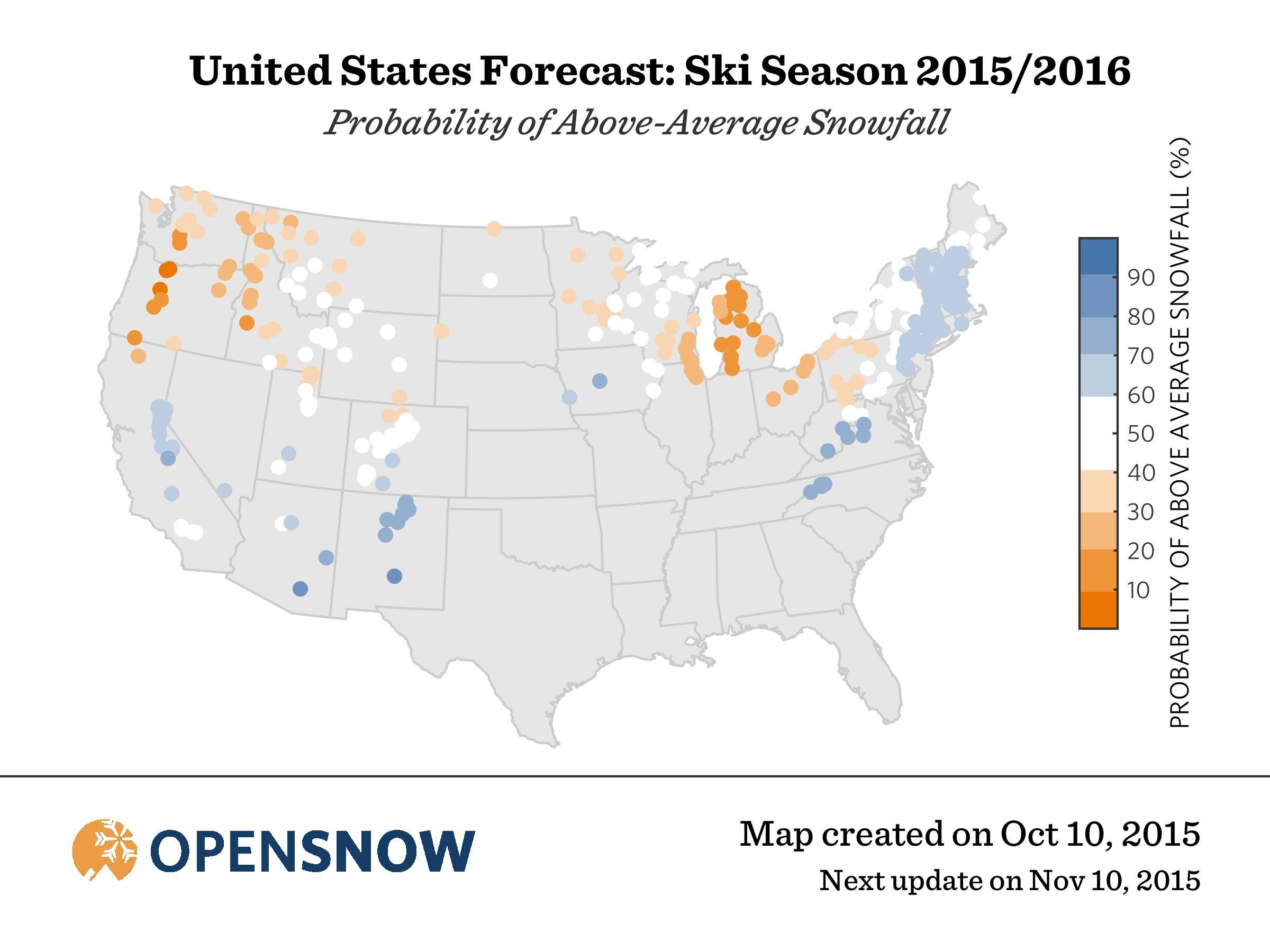
And the same forecast for 2015-2016, now shown for each ski area.
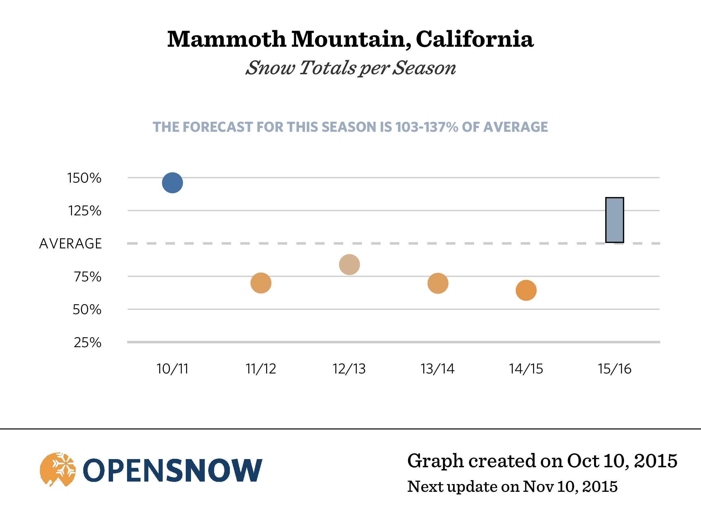
If you are curious how your favorite ski area stacks up, go to their page by searching for the ski area name on the navigation bar above. Once on the ski area’s page, scroll down to see a chart that shows the snowfall for the last five seasons and our forecast for this season’s snowfall. Remember, six-month forecasting is very hard, which is why we provide a range of possible snowfall and not simply one number.
For example, here is our forecast for Mammoth Mountain in California. The last four seasons had below average snowfall, but we are forecasting above average snowfall this season.
And, there’s more! As an additional planning tool, we also created graphics that track the actual snowfall during the season. You can view these images on each ski area’s page, and this will help you to see in real time which ski areas have the most snow, compared to average. As we test this data, the information will be freely available through early December, and then will be viewable only by subscribers.
These forecasts would not be possible without the hard work of Dr. Amato Evan from Scripps Institution of Oceanography. OpenSnow partnered with Dr. Evan on this project and he worked lots of nights and weekends to produce this first-of-its-kind forecast.
For questions, please read the FAQ below or email me directly at [email protected]. If you’d like to get updates on snowfall and see how our forecast progresses during the winter, please sign up for our free email newsletter.
JOEL GRATZ
Founding Meteorologist
OpenSnow.com
[email protected]
FAQ: OpenSnow Winter Ski Forecast for 2015/2016
How can I use these forecasts?
If you’re looking for powder, find ski areas with a higher chance of above-average snowfall and plan your ski vacations accordingly. Remember, though, that there are many factors that go into making a great ski vacation, and total snowfall over a season is only one of them. Travel time, lodging, ski school, and off-hill activities all have an impact. Also, even if we are forecasting that a ski area will see below average snowfall over a 6-month season, they will still likely experience plenty of snow storms and powder days, so don’t be too picky.
Why should I care about these forecasts?
This is the first season-ahead weather forecast that specifically predicts snowfall at ski areas. At least, we think it’s the first. If there is something else out there, let us know. Further, we are transparent in sharing our accuracy statistics and tracking the actual snowfall through the season. We think it makes a lot of sense to share this data.
What if my favorite resort doesn’t get much snow this year?
This is a strong El Nino season, and there is about a 60% chance of a strong La Nina for next season (2016/17). Snowfall patterns tend to be opposite between El Nino and La Nina seasons. So, if you’re unhappy with this year’s snowfall, you might be happier next season.
What is the accuracy of these forecasts?
On average, we get the forecast correct about 60-65% of the time. This is based on testing our forecast method over 36 seasons, from 1979/80 to 2014/15.
How do you define a “correct” forecast?
We define below average as less than 90% of normal snow, average snowfall to be between 90-110% of normal, and above average snow to be greater than 110% of normal. If our forecast and the actual snowfall is in the same category (below average, average, above average), then we count the forecast as correct. This is a simple method and one that aligns with how most skiers make decisions about where to ski. You can view forecast accuracy statistics on each ski area’s page, immediately below our long-range forecast graphic.
Is this information free?
The long-range forecasts are freely available. The tracking of real-time snow compared to average, for each ski area, will be freely available until early December, and then will be available only to subscribers.
How often do you update the OpenSnow Winter Ski Forecast?
Once per month, often around the 10th. As of October 22, 2015, we produce this forecast for 381 out of 390 ski locations in the United States (Canada coming soon).
How often do you update the actual ski area snowfall data?
Every day by around 9am mountain time. As of October 22, 2015, we produce this data for ski areas in the western US and Canada. Specifically, in the states of Alaska, Arizona, California, Colorado, Idaho, Montana, New Mexico, Nevada, Oregon, South Dakota, Utah, Washington, Wyoming, and in the Canadian provinces of Alberta and British Columbia.
How do you make these forecasts?
1) Gather snowfall data from weather stations and weather observers that are near ski areas.
2) Find a relationship between this historical snowfall data and global ocean temperatures. The location of warmer-than-average and colder-than-average ocean temperatures play a key role in creating our global weather patterns.
3) Assess the current temperature of the world’s oceans, and then forecast how these ocean temperatures will change during the upcoming winter season.
4) Combine our estimate of future ocean temperatures with our knowledge of the ocean’s impact on snowfall patterns. Do a bit (or a lot of) math and then bam!, our forecast snowfall at ski areas is complete.
Do your forecasts consider El Nino or La Nina?
Absolutely. But, El Nino and La Nina only refer to ocean temperatures in one area of the Pacific Ocean. We take into account ocean temperatures across the globe.
Are these forecasts and the actual snowfall information based on snow reports from resorts?
Our forecasts and actual snowfall information is based on data that is generated by mountain weather stations (SNOTEL sites) and official weather observers near ski areas. Right now, this data is NOT based on official resort snow report measurements from ski areas. We use weather stations and weather observers because their data is updated automatically and provides consistent measurements over many decades. We do hope to include more data from ski resorts over time.
Are there any parts of the forecast you want to improve?
For sure! We’d love to get more historical snow data and to investigate more subtle nuances of snowfall in various regions (global ocean temperatures can only help us so much). Also, we’d like to add Canada to our forecasts (coming soon!) and try our hand in predicting storm frequency and not just total snowfall.
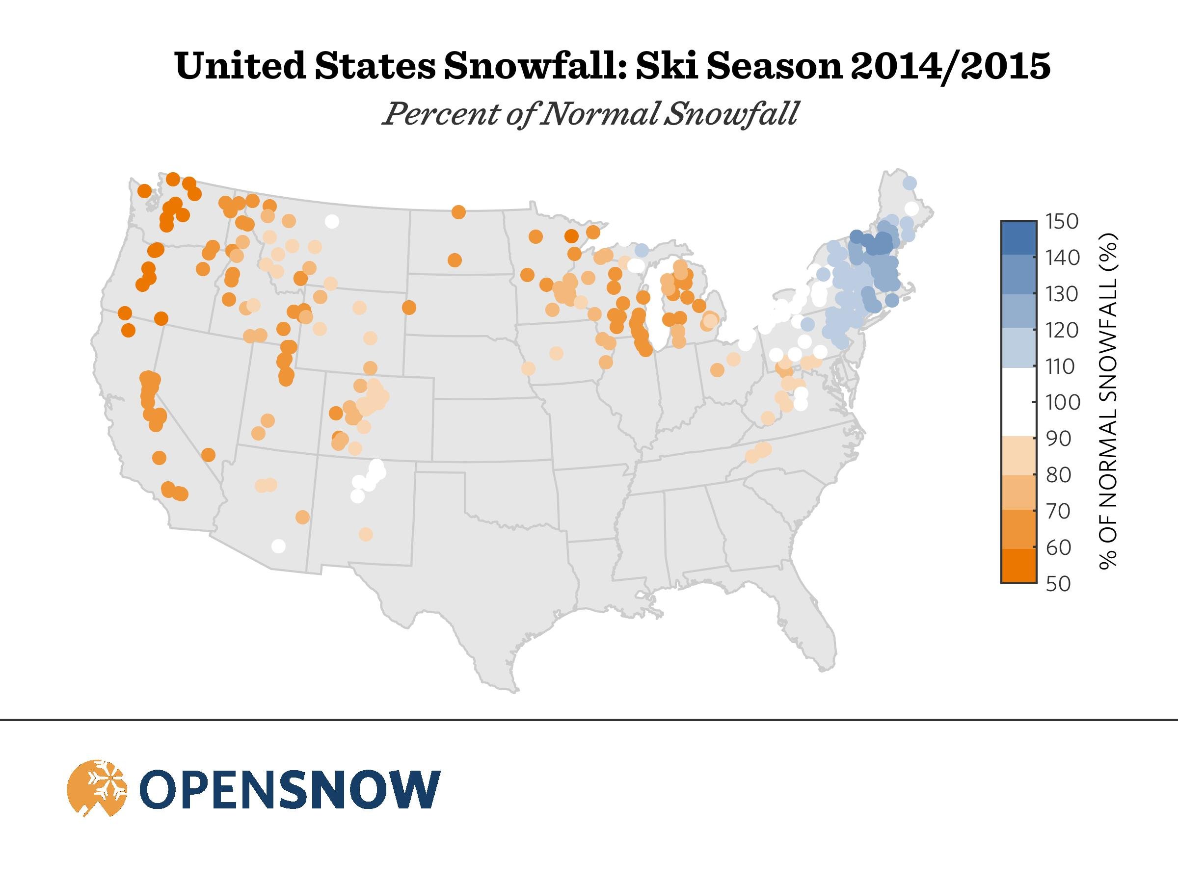
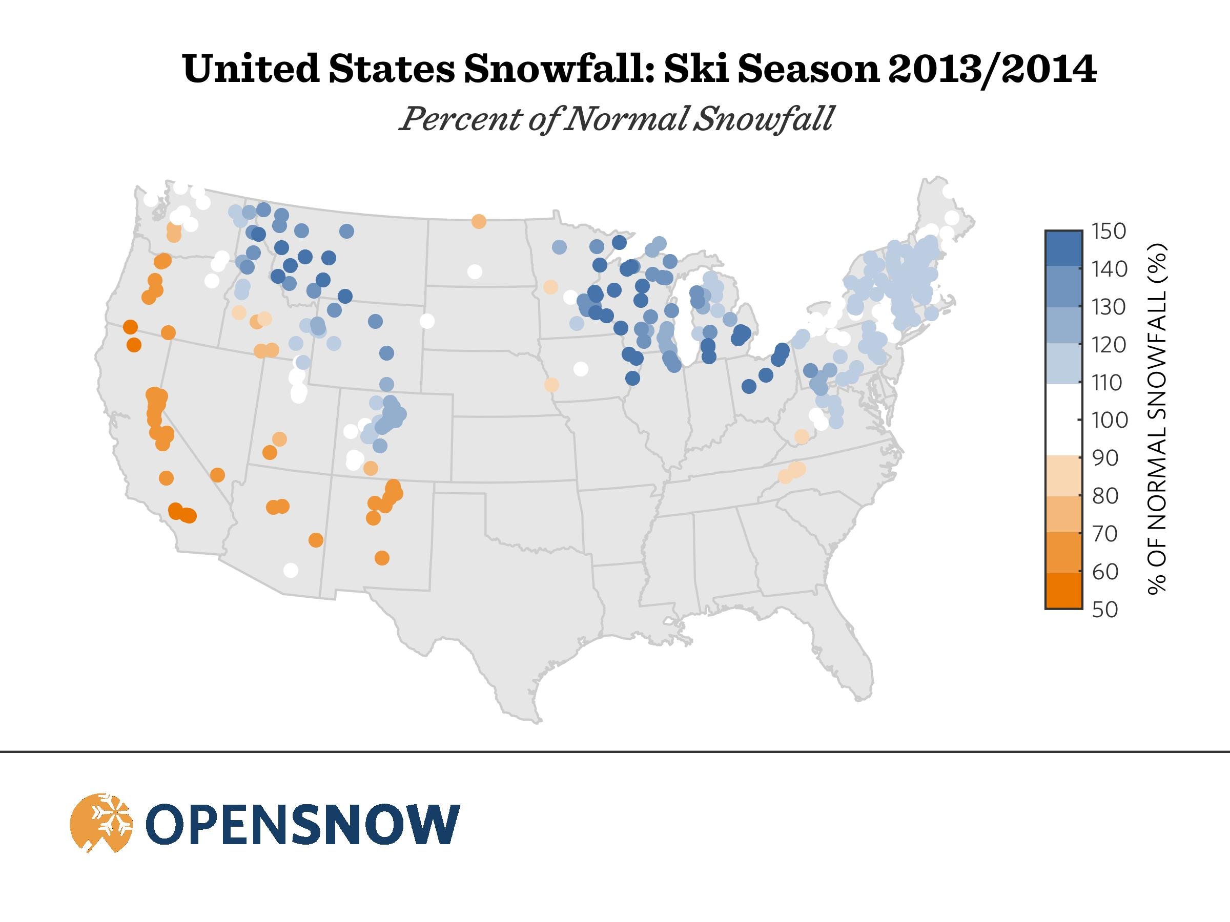
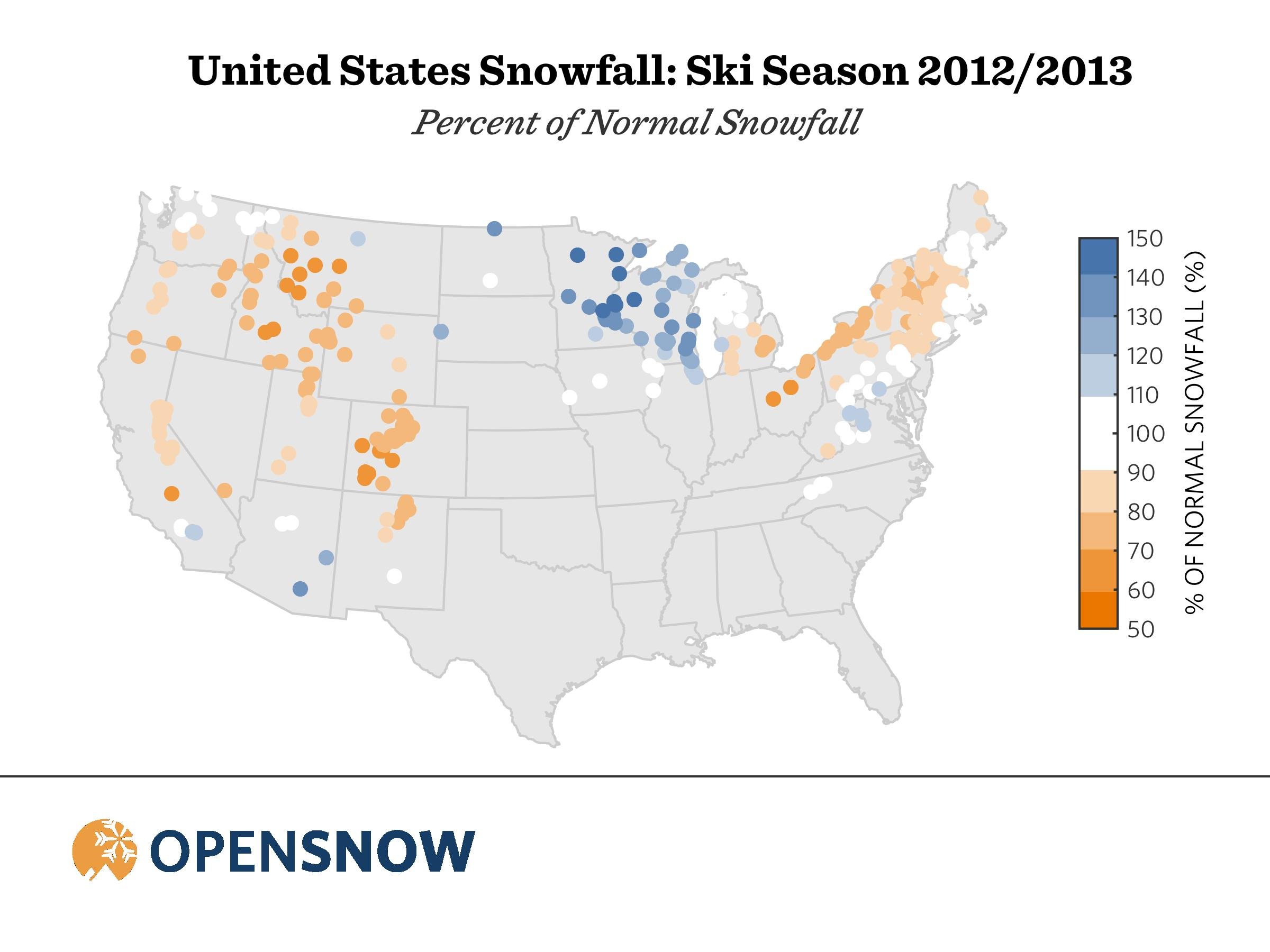
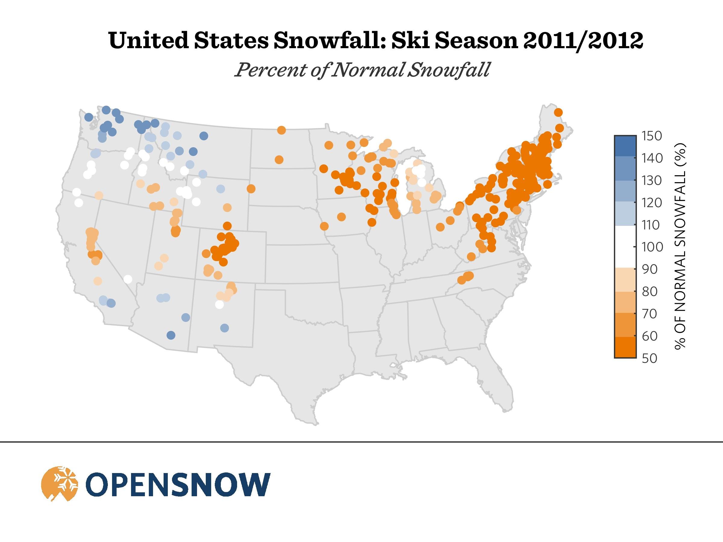
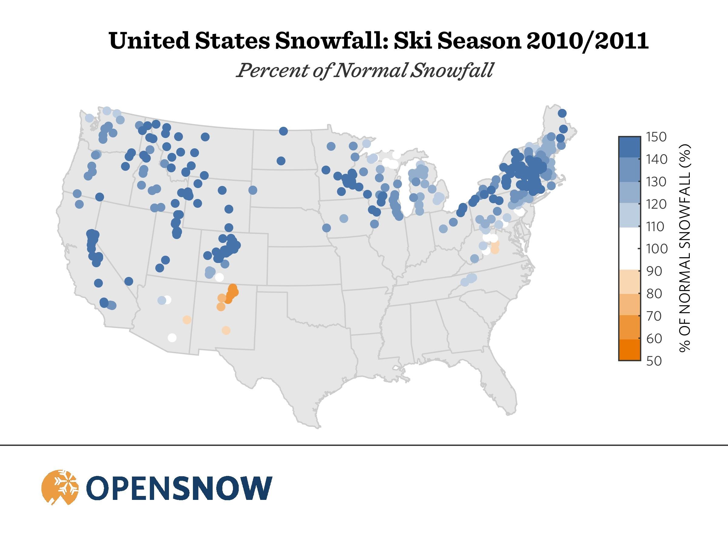
Do you have maps showing snow totals during the last few seasons?
Yes, from 2010/11 to 2014/15. We will post additional historical maps soon.
About The Author


