News

By Alan Smith, Meteorologist Updated 2 months ago May 14, 2025
2025 Western United States Summer Forecast Preview
While spells of cool and wet weather are impacting portions of the West as of this writing in mid-May, the snow is quickly melting in the mountains, and summer is right around the corner.
For the summer 2025 outlook, we examine factors such as the El Nino Southern Oscillation (ENSO) and spring snowpack in the Southern and Central Rockies, which can provide some clues on what to expect this summer, with the caveat that there is an inherent level of uncertainty around long-range outlooks.
ENSO Neutral Conditions Expected
We are currently in an ENSO Neutral phase, and confidence is high that ENSO Neutral conditions will prevail throughout the summer of 2025. This means that neither El Nino nor La Nina conditions are present.
During the winter of 2024-2025, we approached borderline La Nina conditions at times, but failed to meet the criteria of an average sea surface temperature anomaly of at least -0.5°C (-0.9°F) in the Eastern Equatorial Pacific Ocean for five consecutive, overlapping 3-month periods.
As a result, this past winter season will go down as an ENSO Neutral winter, meaning that neither El Nino nor La Niña conditions were present.
Confidence is high that ENSO Neutral conditions will prevail throughout the summer of 2025, and quite possibly into the upcoming fall and winter season, though confidence is low beyond September.

When examining past summer seasons, ENSO Neutral summers tend to favor high-pressure ridging over the Western U.S. and especially over the Northwest and Northern Rockies, more so than what occurs during La Nina or El Nino summers.
The image below shows 500 millibar height anomalies during ENSO Neutral Summers (June to September) dating back to 1990, with darker yellow and red colors indicating higher heights than normal, which correlates to stronger high-pressure ridging than normal.
Blue and purple colors correlate to lower height anomalies and more troughing (dips in the jet stream) than normal.

By comparison, during La Nina summers, high pressure ridging tends to be more focused over the Central U.S., with more frequent troughing (dips in the jet stream) over the West Coast and Pacific Northwest.
During El Nino summers, high pressure ridging tends to be more confined to the Southern Plains with more frequent troughing and a stronger subtropical jet stream over the Southwest and West Central U.S.
ENSO Neutral summers strongly correlate to above-average temperatures across the Western U.S. In other words, summers tend to be long and hot during neutral years.
However, ENSO Neutral summers also correlate to an active monsoon season, especially over western portions of the typical monsoon region, including Arizona, Utah, and Nevada.
Spring Snowpack in the Southern and Central Rockies
Past research has found a connection between spring snowpack in the Southern and Central Rockies and the upcoming monsoon season. We have studied this connection between May 1st snowpack anomalies and summer weather, and have also found similar connections.
Above-average snow cover in the spring across the Southwest and the Rockies often results in the delayed development and northward migration of the summer subtropical high-pressure ridge, which can delay the onset of monsoon and, in some cases, lead to a weaker monsoon season.
This is because a greater amount of solar radiation in the spring is used to melt snow cover rather than heat up the land. But heavy winters followed by warm early springs that lead to early snowmelt can potentially negate the snow cover feedback.
Below-average spring snow cover tends to have the opposite effect, however. An earlier snowmelt allows the soils to dry out more quickly with solar radiation heating up the land earlier in the season.
This tends to result in an early northward migration in the subtropical high-pressure ridge, which can lead to very hot temperatures in June, followed by an early and active monsoon season as monsoonal moisture builds northward and circulates around the high-pressure center.
As of May 1, 2025, snowpack was well below average across the Southern and Central Rockies, which favors strong high-pressure ridging over the Western U.S. (reinforcing what we often see in ENSO Neutral summers), while an early start to monsoon season and an overall active monsoon season are also favored.

Other Factors Considered
We also examined the Quasi-biennial Oscillation (QBO), which has been shown to have some correlations to U.S. weather, at least during the winter months.
Currently, we are in a westerly (positive) phase of the QBO, which is likely to persist through the summer. However, when examining past years, we found close to zero correlation between QBO and summer weather in the Western U.S.
We also looked at ocean temperatures in the Pacific Ocean just offshore of the Western U.S. and the Baja Peninsula. However, we did not find any meaningful results, and ocean temperature anomalies in early May often differ substantially from anomalies in mid-summer.
Top Analog Years and Results
We examined years since 1991 (since averages are based on 1991-2020) and found five years that featured ENSO Neutral summer conditions and below average May snow cover in the Southern/Central Rockies:
- 2012
- 2013
- 2014
- 2018
- 2021
Here are some of the key weather trends we have found in these low snow cover + ENSO Neutral analog summers for the 4-month period from June to September:
- Temperatures tend to be above-average throughout the West and for most of the summer, with an early start to summer heat in June and often a late finish in September. In other words, summers tend to be long and hot with more frequent and more intense heat waves than usual.
- Monsoon season tends to be very active and often starts early (by late June or early July) with the highest rainfall anomalies over Arizona, Utah, Nevada, Southern/Western New Mexico, and to a lesser extent Western Colorado.
- The Colorado Front Range and Northern New Mexico and adjacent plains tend to have drier than normal Junes, while July to September rainfall has equal chances of being above or below normal (note, however, that 2013 is an analog which featured record rainfall in this region).
- The Northern Rockies and the Sierra tend to be drier than normal in June, but more active during monsoon season in July and August with near to above average rainfall favored. The Northern Rockies in particular tend to be more favored later in the summer in August.
- The Pacific Northwest tends to be even drier than normal during its traditional dry season in July and August, but also tends to have wetter than normal Septembers as fall low pressure systems begin to arrive. June also tends to be near average in terms of rainfall, unlike most other parts of the West.
- Wildfires and smoke could potentially be problematic again this year due to hotter and drier than normal conditions favored in early summer for many areas, though some areas could also see mid to late summer monsoon season relief. Areas at the fringe of monsoonal moisture will also be at risk for lightning-triggered wildfires.
Here are some graphical projections of what we are expecting in terms of precipitation and temperature relative to normal this summer:


Next, let's take a look at favored weather patterns during early, mid, and late summer...
Early Summer (June)
During the analog years examined, summer often comes in strong in June with well above normal temperatures favored, while most of the West tends to see below normal rainfall.
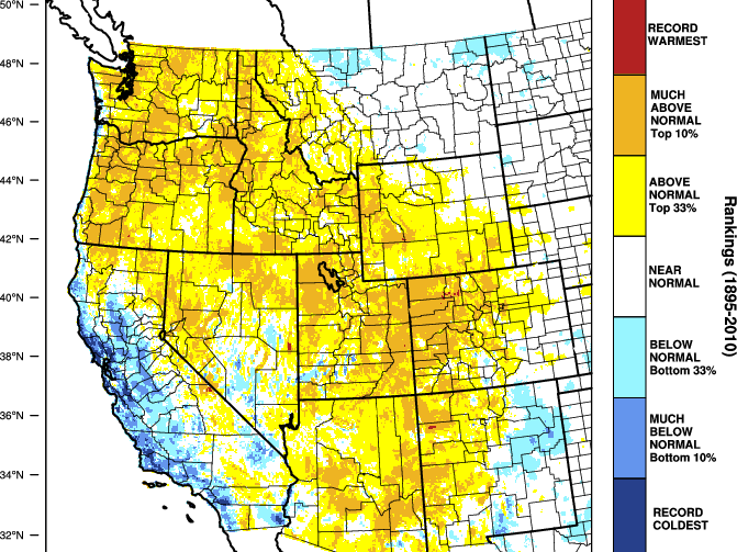
June temperature anomalies during ENSO Neutral + low snow cover analog years:

June precipitation anomalies during ENSO Neutral + low snow cover analog years:

Mid-Summer (July and August)
During monsoon season, areas west of the Divide tend to see the heaviest rainfall in these analog years, especially Arizona and Utah. An active monsoon can also take the edge off the heat somewhat across the Southwest, although this is relative, of course.
Above-average anomalies extending into the Sierra Nevada Range and Idaho/Wyoming suggest that northern and western monsoon moisture intrusions (outside of the core Four Corners region) are also common.
July/August temperature anomalies during ENSO Neutral + low snow cover analog years:

July/August precipitation anomalies during ENSO Neutral + low snow cover analog years:

Late Summer/Early Fall (September):
During these analog years, September tends to feature a lingering monsoon over the Four Corners states, perhaps a bit later than usual, while early fall low-pressure systems also tend to bring heavier-than-normal rainfall to the Pacific Northwest.
Temperatures tend to be closer to normal over the Northwest and the far Southwest, while the Central Rockies and California tend to be warmer than average, suggesting that summer's heat may be slow to relent.
September temperature anomalies during ENSO Neutral + low snow cover analog years:


One interesting note is that 2013 is one of the five analog years that featured low spring snow cover and an ENSO-neutral summer.
During September 2013, the Colorado Front Range experienced record rainfall and extreme flash flooding. This was an anomaly that required a "perfect storm" of atmospheric conditions to come together and probably doesn't mean anything for this year. But nevertheless, it's interesting to see 2013 show up as an analog.
Limitations of Seasonal Forecasting
While these past signals are fun to examine and offer some insights as to what we might expect this summer, keep in mind that seasonal outlooks should always be taken with a grain of salt. There are many factors in the atmosphere that cannot be anticipated months in advance, and every year is unique in its own way.
We will continue to monitor oceanic and atmospheric conditions this summer, including the ENSO forecast for the winter season, which is uncertain right now but will likely favor either Neutral or La Nina conditions. Stay tuned for a Winter 2025-2026 forecast this fall!
OpenSnow: Your Daily Weather App
As the snow begins to melt and summer conditions quickly take over, remember that you can always use OpenSnow as your daily weather app during the non-winter months.
Getting Started

View your current location conditions under the "My Location" screen, avoid poor air quality and incoming storms with our summer-focused map overlays under the "Maps" screen, and check the "Weather" tab under any location screen for hourly temperature, precipitation, wind, cloud cover, and lightning forecasts.
You can also view the hourly forecast for the next 10 days for any location on Earth in OpenSnow.
- Go to the "Maps" tab.
- Tap anywhere or search for a location.
- Tap "View Forecast".
View → My Location
Alan Smith
About The Author


