Colorado Daily Snow

By Joel Gratz, Founding Meteorologist Posted 9 years ago November 19, 2014
November to remember?
Summary:
- Dry through midday Saturday
- First storm arrives Saturday night with 3-6+ inches for most areas
- Continued snow for most of Colorado Sunday, Monday, Tuesday
- Plus, it might snow every day next week (!)
Details:
No need to bury the lede. The gist of today's update is that powder days are in your future, starting on Sunday and potentially getting better and deeper through early next week.
As a forecaster, I'm trying to temper my excitement because the snow is still a week out and subtle changes in the forecast details can mean big changes to eventual snow totals.
As a skier, I'm wiggling in my chair from excitement because of the likelihood of skiing more pow in November. A November, mind you, that started with 9 days of dry weather and pushed some of folks into early-season despair.
Ok, here's the scoop:
Wednesday, Thursday, and Friday will be generally dry with a few more clouds each day. I could see a few flurries or snow showers on Thursday or Friday, but the responsible storms are very weak and likely won't be able to create consistent precipitation.
Saturday will be the lead-up day. Increasing clouds and perhaps a few snow showers late in the day.
On Saturday night a cold front will bring snow to most areas. Favored locations by a west or northwest wind should see 4-7 inches from Saturday night through Sunday morning with other areas getting 3-5 inches. More details for each ski area here (I update this page daily): http://opsw.co/CO1-5
Then ... northwest flow will setup on Sunday and last through at least Tuesday. For those of you that have been reading for a while (thank you!), you know that northwest flow can be awesome. For new readers, here's the scoop on northwest flow.
A wind from the northwest (go figure) brings consistent moisture and waves of storm energy over Colorado. This wind direction favors mountains along and north of I-70, Irwin to the west of Crested Butte, and can also favor the northwest side of the San Juans around Telluride and Silverton if the energy pushes far enough south. Other areas can see ok snow, but the above areas are usually the winners.
The cool thing about northwest flow is that it sets up the atmosphere in a way that is conducive for heavy snow for the areas I mentioned over multiple days. That said, it's nearly impossible to predict exactly when each wave of storm energy will move through the flow. So what generally happens is that we'll see 2-3 days of snowfall with times of lighter snow and times of unexpectedly heavier snow. And by day two or day three, the effect of multiple days of snow without a break usually creates fantastic powder conditions and a few spots with surprisingly high totals. So...
Sunday, Monday, and Tuesday will be dominated by northwest flow. For the favored areas I mentioned above, expect perhaps 2-4 inches each day and night of this time period. As we get closer to early next week, I may be able to time the waves of heavier snow. But for now just consider the possibility of good powder each day early next week.
Here's a map of the northwest flow, which is generally positioned under the jet stream separating colder air to the north (blue colors) and warmer air to the south (orange colors).
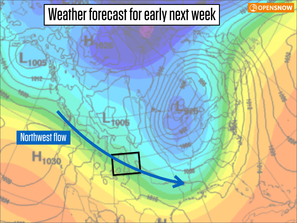
Source: Meteocentre
Wednesday will likely offer a break in the snow, though I can't say it's going to be a completely dry day because that northwest flow will still be close.
Next Thursday and Friday will likely bring one more storm to the entire state. Stay tuned on details.
So, the deal is that we could see snow each day from Sunday through next Friday. As Matt Damon would say:

In the longer range I see a fairly active pattern continuing for the west into early December. Of course I can't offer more details than that, but overall, things are looking good for early season.
JOEL GRATZ
About Our Forecaster
Joel Gratz
Founding Meteorologist
Joel Gratz is the Founding Meteorologist of OpenSnow and has lived in Boulder, Colorado since 2003. Before moving to Colorado, he spent his childhood as a (not very fast) ski racer in eastern Pennsylvania.
Free OpenSnow App


