Colorado Daily Snow

By Joel Gratz, Founding Meteorologist Posted 9 years ago November 26, 2014
The goods were delivered
Summary:
- Light snow for northern Colorado on Wednesday morning
- Generally dry Thursday through early next week
- Storm likely during middle of next week, but...
- ...the details of next week's forecast are impossible to figure out
Details:
Yesterday was another remarkable day along I-70. Scroll down and hit the orange box below this post to go back and time and read the updates. In short, I was pessimistic about yesterday's snow potential due to warmer air moving in aloft and the models generally overforecasting snow in that situation. And that pessimism was validated in a tiny way as Steamboat reported 5.5 inches (not the 12-18 inches that the models forecasted), and Keystone reported 4 inches with Beaver Creek at 5 inches.
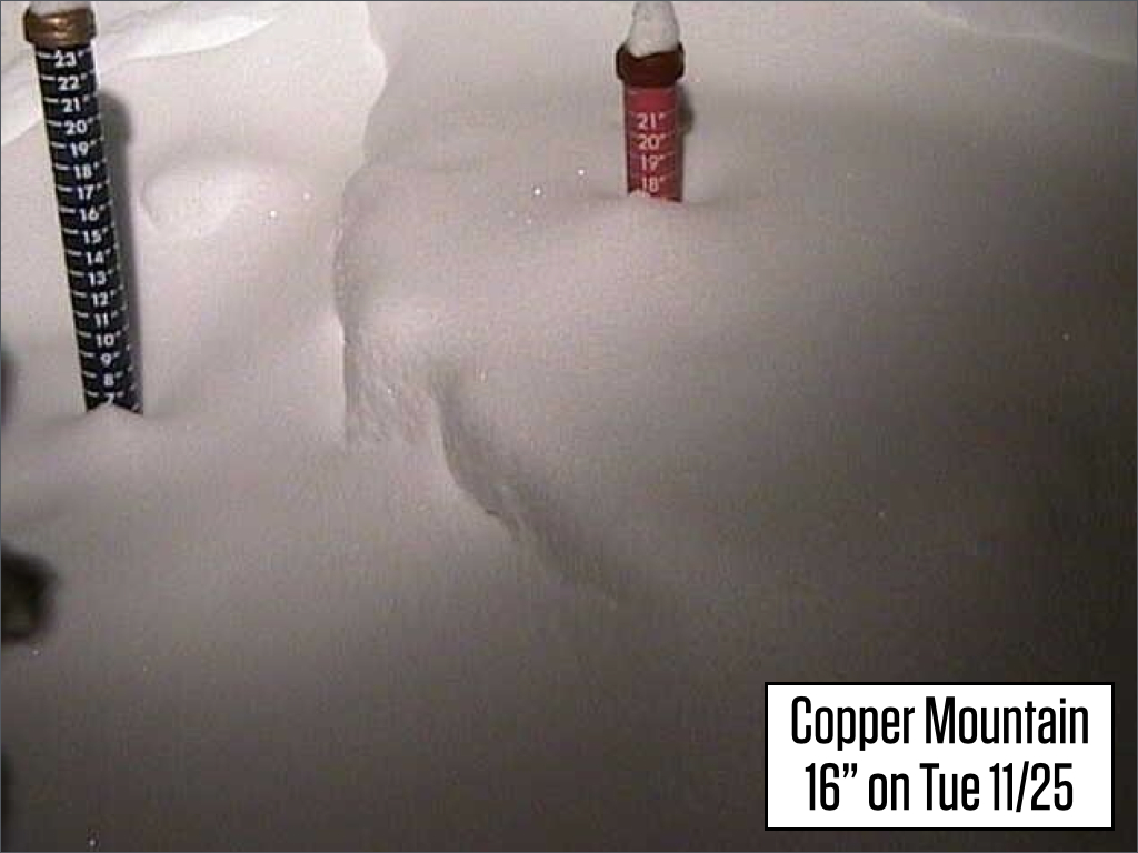
However, other areas saw very intense snowfall during the day yesterday. Copper leads the list with 16 inches, Breckenridge and Abasin had 12 inches, Loveland came in with 11 inches, Vail with 9 inches, and Winter Park with 7.5 inches. Here was Copper Mountain's snow stake cam before it was cleared this morning:
The forecast models showed the possibility for 12-18 inches of snow, but they also showed this total split between Tuesday day and Tuesday night. In reality most of the snow fell during Tuesday day with just an inch or two falling after about 6pm Tuesday night. So some models did get the right answer but over the wrong time period. Hard to figure this one out. Looking back at my notes over the past few years, it seems like the last day of northwest flow can favor I-70 while Steamboat is favored the day before. Not much science in that explanation, but it's what I have for now.
In any case, get out there and enjoy. Temperatures are much warmer this morning with readings in the mid 20s, so my guess is that a lot of yesterday's snow has set up and will ski much heavier today compared to yesterday's blower.
Moving on...
Wednesday: Snow ends over the northern mountains by mid afternoon if not earlier.
Thursday through Sunday: Should be dry everywhere with warmer temperatures (mountain highs in the 30s).
Sunday evening through Tuesday: I think we'll stay dry, but the latest models show a bit of snow for northern Colorado. In reality neither the models or myself have a clue what will happen during this time.
Next Wednesday/Thursday/ish: This will likely be the time when we see the next significant storm move through Colorado. That said, I have zero confidence in any of the details around this storm.
Happy early Thanksgiving!
JOEL GRATZ
About Our Forecaster
Joel Gratz
Founding Meteorologist
Joel Gratz is the Founding Meteorologist of OpenSnow and has lived in Boulder, Colorado since 2003. Before moving to Colorado, he spent his childhood as a (not very fast) ski racer in eastern Pennsylvania.
Free OpenSnow App


