Colorado Daily Snow

By Joel Gratz, Founding Meteorologist Posted 11 years ago October 23, 2012
Tahoe just got whooped with TWO FEET of snow and it's snowing in Utah and Jackson in addition to most areas of Oregon, Washington, Idaho, and Montana. It's good to see others getting the flakes, but we want some of that for Colorado, right?
Well, it's coming. The models are still fighting like a married couple, but the storm is becoming a bit clearer.
A few showers are covering the mountains near I-70 this morning, but those will dissipate soon. The main storm won't arrive until midday Wednesday.
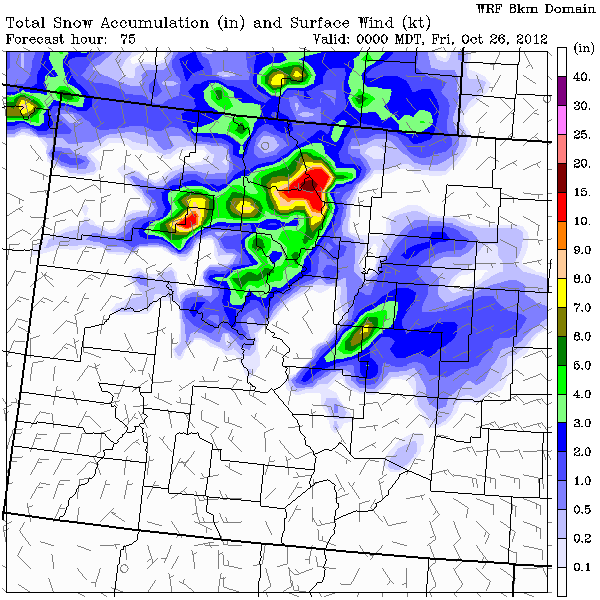
The first part of the storm will arrive as a cold front on Wednesday afternoon and produce the heaviest snow from about sunset Wednesday night through just after midnight Wednesday night / Thursday morning. Most accumulating snow will be from Aspen and north, with the I-70 areas seeing 3-6" ish and areas north along the divide seeing closer to 10".
Snow will then mostly stop Thursday morning, but snow showers will develop for many mountain areas from Aspen and north during the day on Thursday. Think of these snow showers like afternoon thunderstorms where the ground heats up, air rises, and little "popcorn" showers pop up. I don't anticipate much accumulation, but another randon inch or two is likely.
Here's the snowfall map from Wednesday afternoon through Thursday at midnight, with most of this snow falling from 6p Wednesday through about 3am Thursday morning:

The second part of the storm will come through Thursday night, between about 6pm and 6am Friday morning. This will mostly bring snow to the foothills east of the divide where another 3-6+ inches could fall. The mountains to the west could see another inch or two and this could extend further south to the San Juans. However, this part of the storm is more uncertain than the first, so stay tuned.
After the storm leaves on Friday, we might see a few snow showers especially north of I-70, but the accumulating snow will be bye bye. The weekend will be cool but dry and the next storm looks like it could arrive toward the middle of next week, right around Halloween.
JOEL GRATZ
About Our Forecaster


