Colorado Daily Snow

By Joel Gratz, Founding Meteorologist Posted 8 years ago June 5, 2015
Sunday looks slightly drier than Saturday
Summary
- Showers ongoing for Friday afternoon
- Showers continue Saturday morning for western/southern Colorado
- Saturday afternoon should be rainy most places
- Sunday afternoon will be drier than Saturday, but still a few showers
- Monday & Tuesday will be dry
- Wednesday is iffy, not sure
- Showers return for all areas next Thu/Fri/Sat/Sun
Details
Thursday afternoon was very active over the front range. A large supercell thunderstorm spawned numerous tornadoes south and west of Limon while another storm produced a rare east-to-west moving tornado just north of Longmont. Further, some areas received 2-4 inches of rain, many inches of hail, and lots and lots of lightning. The crew at Weather5280 has a great summary here: http://opsw.co/1T25Lsp
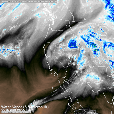
For the mountains, we are currently under the influence of a slow-moving storm that is spinning over California. This pattern is allowing moisture to stream into Colorado from the southwest. The water vapor satellite image below illustrates the details. Moisture in the mid and upper levels of the atmosphere is shown as the grey and blue areas.
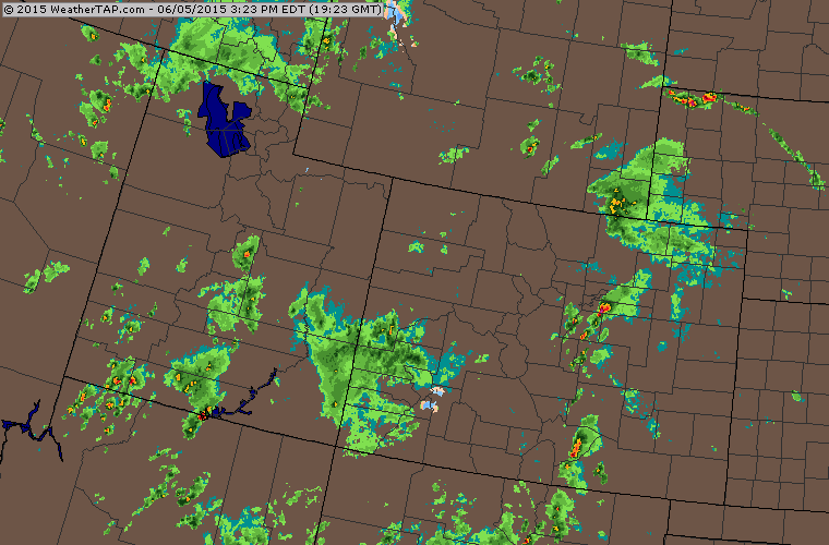
Checking the radar, it is active as of 3pm on Friday afternoon. A batch of showers is pushing through the San Juans and areas west of Crested Butte and Glenwood Springs, and these showers should push east across all mountains by this evening. Snow levels are quite high, around 14,000 feet, so most mountains will see precipitation fall as rain.
If you're trying to plan outdoor activities this weekend, here's what to expect.
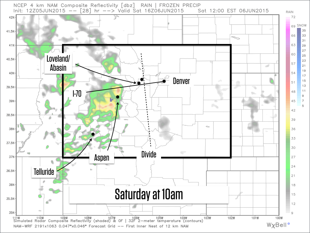
On Saturday, showers will be ongoing in the morning in the San Juans and for areas west of Aspen, Crested Butte, and Glenwood Springs. These showers should push east and cover all mountains by about noon to 1pm, and the rest of the day should be showery. Below is the forecast radar at 10am on Saturday morning.
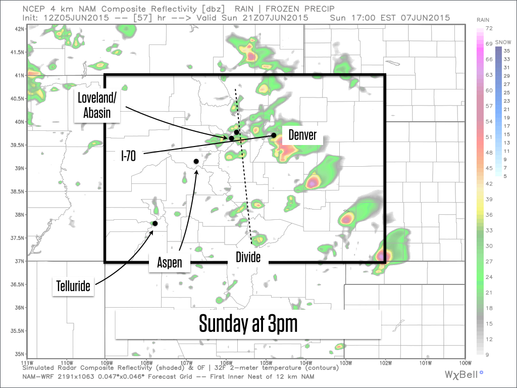
Sunday will likely be a better day with fewer showers. Look for drier weather in the morning, followed by a few showers during the middle of the day and afternoon. Most of these showers could form closer to and east of the divide, so areas further south and west (like Aspen, Crested Butte, Steamboat, and the San Juans) should experience a much drier day than Saturday. Don't let your guard down, though, as all of the moisture from previous day's rain can help the atmosphere create more showers than the models expect. Below is the forecast radar for Sunday afternoon at 3pm.
You should be able to find some times of dry weather this weekend on both days, so don't let our rainy pattern stop your fun. If I had to pick a day for a lengthy outdoor activity in the mountains, I would pick Sunday.
Looking ahead, Monday and Tuesday should be dry, and I think this will last one more day into Wednesday, though I'm not completely sure. Then the moisture from current Hurricane Blanca will push into Colorado on Thursday, so look for showers to return each day from Thursday through next weekend.
If you missed my post on Thursday, I copied a few things below about El Nino and also about the start of our summer forecasts next week. At that time, I will transition most of my writing from here to our summer email list, so be sure to sign up below.
Have a great weekend, and thanks for reading:-)
JOEL GRATZ
El Nino updates
The main point is that a moderate El Nino is occurring in the Pacific Ocean, it is strengthening, and most models project its peak intensity to occur later in the fall. What exactly all of this means for Colorado isn't certain and will depend on its strength as we move past the fall and into next winter.
Bryan Allegretto and Evan Thayer wrote recent updates about El Nino's impact on Tahoe and Utah, so give those a read and I'll keep an eye on things for Colorado and let you know of any updates.
El Nino and Tahoe snowfall, Bryan Allegretto, June 2, 2015:
http://opensnow.com/dailysnow/tahoe/post/4102
El Nino and Utah snowfall, Evan Thayer, June 2, 2015:
http://opensnow.com/dailysnow/utah/post/4100
Summer forecasts
As promised, next week we will start our summer forecasts, focusing on hiking in the mountains of Colorado. Initially, these forecasts will be delivered by email only, once per week, on Thursday morning to help you plan your weekend adventures. To sign up for the email, go here: http://trailforecast.com/
Initially we are going to focus these forecasts on Colorado and specifically on mountain ranges that contain 14ers as these mountains attract a lot of hikers. But I think the forecasts will be useful even if you're not specifically hiking a 14er.
Geography Key
NORTHERN MOUNTAINS
Steamboat, Granby, Beaver Creek, Vail, Ski Cooper, Copper, Breckenridge, Keystone, Loveland, Abasin, Winter Park, Berthoud Pass, Eldora, Rocky Mountain National Park, Cameron Pass
ALONG THE DIVIDE
Loveland, Abasin, Winter Park, Berthoud Pass
EAST OF THE DIVIDE
Eldora, Rocky Mountain National Park, Cameron Pass
CENTRAL MOUNTAINS
Aspen, Sunlight, Monarch, Crested Butte, Irwin, Powderhorn
SOUTHERN MOUNTAINS
Telluride, Silverton, Durango, Wolf Creek (Telluride and Silverton are on the northern side of the southern mountains)
About Our Forecaster
Joel Gratz
Founding Meteorologist
Joel Gratz is the Founding Meteorologist of OpenSnow and has lived in Boulder, Colorado since 2003. Before moving to Colorado, he spent his childhood as a (not very fast) ski racer in eastern Pennsylvania.
Free OpenSnow App


