Tahoe Daily Snow

By Bryan Allegretto, Forecaster Posted 9 years ago March 9, 2015
Tale of Two Winters
Summary:
Sunny and mild weather through Tuesday. Tuesday night into Wednesday a weak system will bring light rain and snow to the Tahoe basin. We could see 1-3 inches above 7000 feet with 3-6 inches possible West of the lake along the crest. By Thursday high pressure builds back in with dry weather and warming temps into the weekend. Another system will move through just to our North this weekend. It looks like most of the precip will stay to our North. Week 2 looks dry as well.
Details:
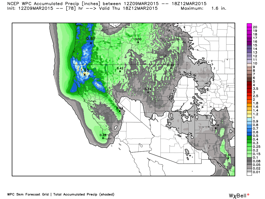
Not much change today in the forecast. Still expecting a weak system to bring a couple waves of moisture into the area Tuesday night into Wednesday. It looks like the snow could begin in the early morning hours with most precip falling during the day Wednesday.
Snow levels will start off close to lake level and then rise to 7000-7500 feet during the day Wednesday. The forecast models are pretty consistent on .1 to .25 inches of liquid over the basin so the forecast is for 1-3 inches on the mountains above 7000 ft. by Wednesday night. Along the crest they are pushing up to a half inch of liquid, especially NW of the lake, so the forecast is for 2-4 inches SW of the lake above 7k and 3-6 inches NW of the lake.
Checkout the individual resort forecast pages. Click on a mountain and you will see that we added in the snow level forecasts and how they relate to the mountains base elevation. We will continue to fine tune it and bring you more snow forecasting tools!
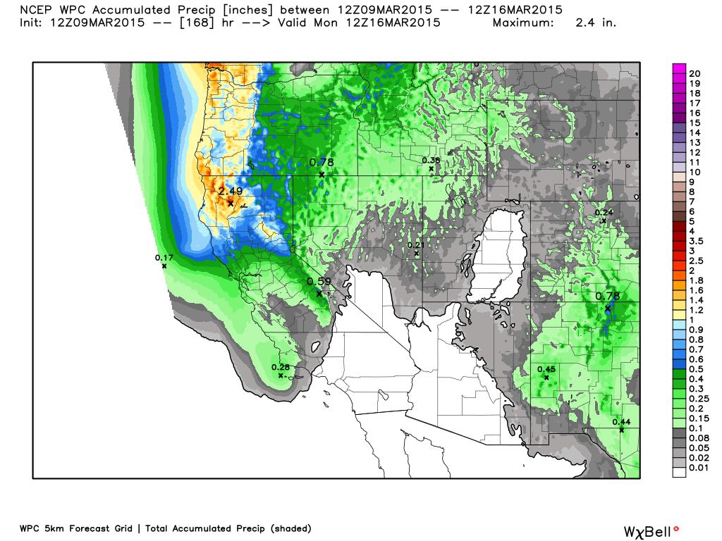
We will warm up again behind this system. Low pressure in the Northeast Pacific will push another system into the Pacific NW over the weekend. Model trends have been to keep most of the precip to our North with only some clouds and maybe a light shower. Looking at the total precip forecast through the weekend you can see the increase in amounts to our North but not much change around the basin.
Long-Range:
High pressure looks to stay along the West Coast next week and shifting North over time. That should keep us dry in the extended for now. As usual some hints of precip The 2nd half of week 2 coming under the ridge into CA.
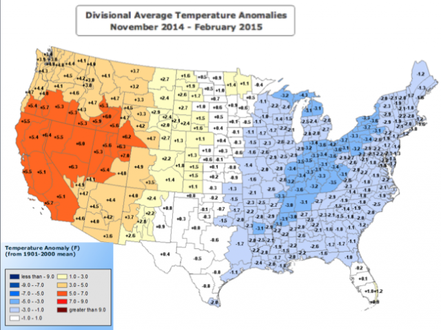
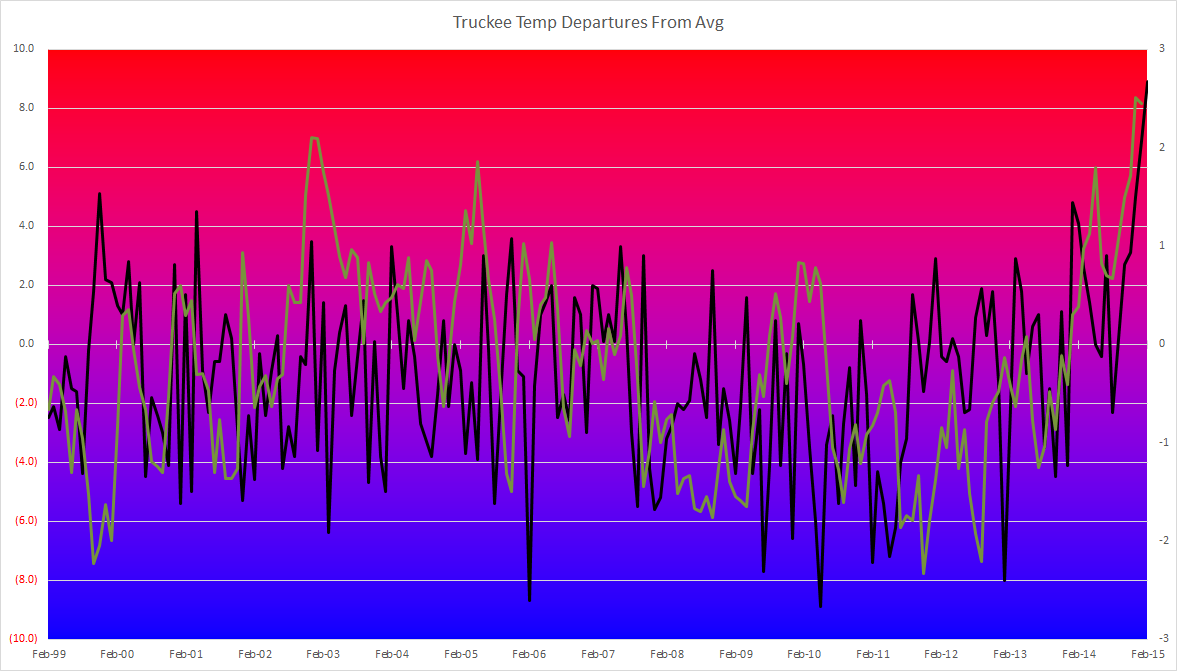
February ended at 8.9 degrees above average for Truckee. The entire West has had a warm Winter so far while the East a cold Winter. If you talk to someone from the East they are talking about how cold and snowy it has been. It has been almost 2 different Winters almost perfectly split down the middle.
I have been plotting the Truckee temperature departures from average the last 20 years. You can see how warm this Winter has been on top of dry. I overlaid the PDO (Pacific Decadal Oscillation) in green. There may be some correlation to the record positive PDO and warm water off the West Coast this Winter to the persistent ridge with warm and dry conditions, and to the persistent cold over the East. As well as other factors.
Whatever is causing the pattern let's hope that it is different next Winter.
Stay tuned....BA
About Our Forecaster
Bryan Allegretto
Forecaster
Bryan Allegretto has been writing insightful posts about snow storms for over the last 15 years and is known as Tahoe's go-to snow forecaster. BA grew up in south Jersey, surfing, snowboarding, and chasing down the storms creating the epic conditions for both.
Free OpenSnow App


