News

By Joel Gratz, Founding Meteorologist Posted 9 years ago August 21, 2015
El Nino Part 2: How much snow fell during previous El Nino winters?
In part one of this series I gave a quick and basic overview of what El Nino is and why it impacts snowfall during the winter.
Now I want to look back at historical El Nino events. Why is this useful? The past can be a decent guide to the future because previous weather patterns can repeat themselves to a certain degree. If we understand how much snow fell during past El Ninos, we could get a glimpse to what this upcoming winter (2015-2016) has in store.
This upcoming El Nino is forecasted to be strong or very strong.
Most forecasters and computer models believe that water temperatures in the Nino 3.4 region will reach 2 degrees (or more) above average, in degrees Celsius. El Nino is classified by how many degrees water temperatures are above average readings. A value between 1.0-1.4C above average is a moderate El Nino, between 1.5-1.9C above average is a strong El Nino, and 2.0C or greater is a very strong El Nino. So, forecasters are predicting that this season’s El Nino will be strong to very strong.
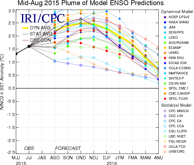
What previous winters have featured a very strong El Nino?
El Nino was in the very strong category during the winters of 1982-83 and 1997-98, so let’s look at what happened during those years.
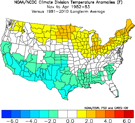
What were the temperatures during the past strong El Nino winters?
Temperatures compared to average in 1982-83:
Temperatures compared to average in 1997-98:
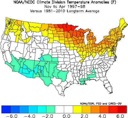
The temperature signal is pretty clear: warmer over the northern states, cooler over the southern states, and close to average in between.
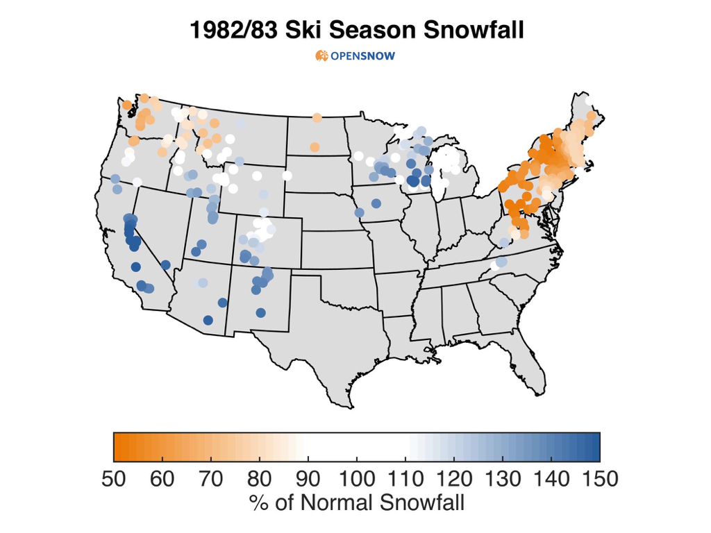
How much snow fell during the past strong El Nino winters?
Snowfall compared to average in 1982-83:
Snowfall compared to average in 1997-98:
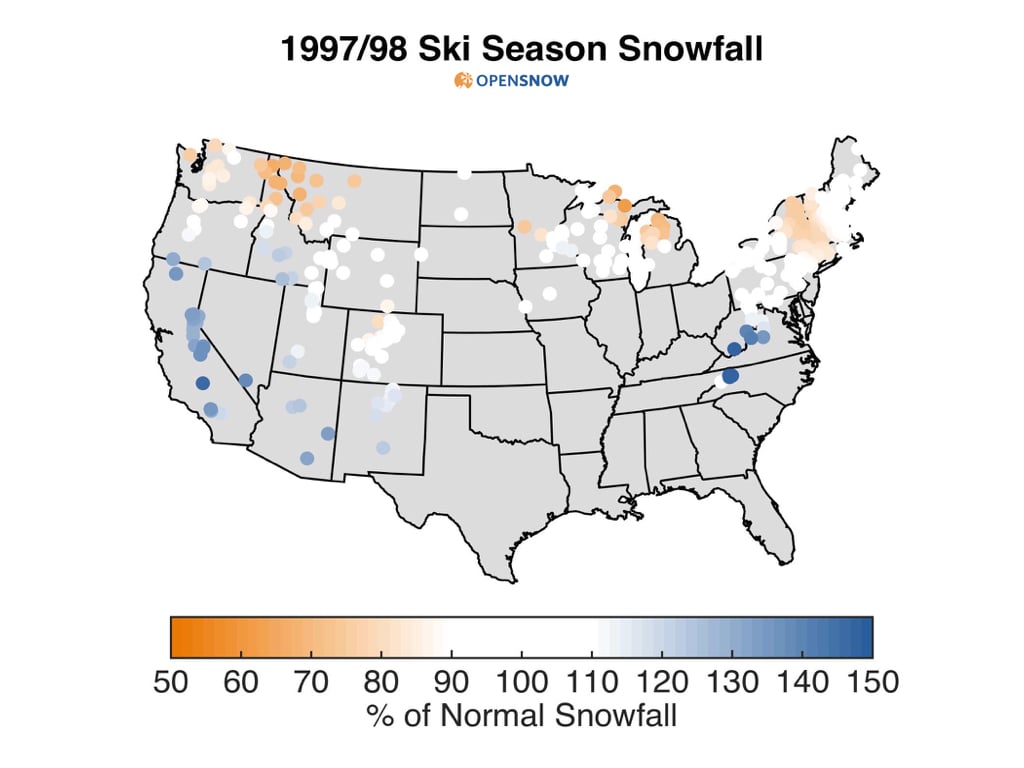
The snowfall signal is not as consistent as the temperature signal, but we can still see the trend. The southwestern US did well both years, while the northwest saw lower than average snowfall.
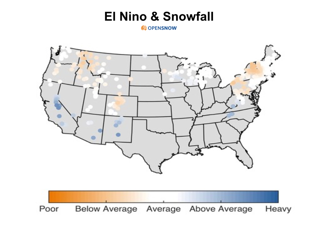
Instead of looking at just two El Nino seasons, how about searching for a larger correlation?
So far, this analysis has only considered two seasons that each had a very strong El Nino. This is a targeted yet small sample size.
Another way to analyze the past is to isolate the El Nino signal across many years and then determine the correlation with snowfall. The graphic below does just that and shows the general trend in snowfall when there is a moderate to strong El Nino.
Summary
If you wrap up these graphics into a simple takeaway, you’d be left with the impression that snowfall and temperature trends are relatively easy to predict during strong El Nino years. Warm with less snow in the northwest, cool with more snow in the southwest, and no clear signal in the middle.
Caveats
But, El Nino is not the only factor that influences global weather patterns. Water temperatures in the rest of the Pacific Ocean (PDO), especially warm water in the northeast Pacific Ocean (the Blob), and water temperatures in the Atlantic Ocean (AMO) all influence snowfall. And there are even more acronyms I could throw out, but I’ll spare you the details.
The presence of a strong El Nino does add meaningful skill to the long-range weather forecast for this winter, but it still doesn't guarantee that a 4-6 month forecast will be accurate.
Next article in the series...
Now that you know what El Nino is (previous article) and know how previous very strong El Ninos have influenced snowfall (this article), you’re primed to take a look at a few snow forecasts for the upcoming season. Those snow forecasts are in the next article, which was posted on Monday, August 31st.
JOEL GRATZ
Extra information
1) A wonderful correlation between ski area snowfall and El Nino by Tony Crocker.
2) List of El Nino Seasons:
Very Strong: 1982-83, 1997-98
Strong: 1957-58, 1965-66, 1972-73
Moderate: 1963-64, 1986-87, 1987-88, 1991-92, 2002-03, 2009-10
About The Author


