South America Daily Snow

By Luke Stone, Forecaster Posted 1 year ago October 4, 2023
Weekend Storm Trending Stronger, Decent Pow Day Possible
Summary
The weather gods do not care that is it October and only a handful of resorts remain open. The weekend storm has trended stronger in the models over the last few days, increasing the chances for a solid pow day on Saturday for Corralco and Antillanca. Four waves of moisture will keep the chances for light snow going through the early part of next week.
Short Term Forecast
Forecast for Wednesday 10/4 - Thursday 10/5
Wednesday and most of Thursday will be warm and dry, with temperatures climbing above freezing during the afternoon. Thursday will be cooler than Wednesday, as a cold front arrives in the afternoon. A few snow/rain showers are possible in the afternoon as well.
Forecast for Friday 10/6 - Tuesday 10/10
A series of weak to moderate and southerly tracking storms will impact the central zone beginning on Friday. You can see the four waves move through the southern part of South America from Friday through Wednesday.
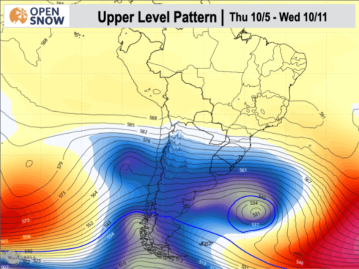
Due to the southerly track, the central and southern zones, especially the Chilean resorts, will be favored. The impacts will be minor at Valle Nevado in the northern zone.
Snow will begin for most on Thursday night, accompanied by strong winds and still fairly warm temperatures. Snow levels should sit right around or just below base elevations at this time, approximately 1200 - 1500 m.
By morning, expect 5 - 12 cms at Antillanca and Corralco. Winds will be strong enough for some minor impacts to the lifts.
Snow will continue Friday, as temperatures continue to fall, with another 8 - 20 cms accumulating during the day. Snow will become more showery in nature, but will continue Friday night and Saturday as well.
Antillanca is only open on weekends, so the storm total through Saturday will be waiting for you when they open in the morning.
With the disturbances moving through on the weekend and early next week, snow showers will be possible and likely during the rest of the weekend and through Tuesday as well. The snow could pick up a little bit Monday night and Tuesday, before tapering off Tuesday night.
Extended Forecast
Outlook for Wednesday 10/11 - Sunday 10/15
Outside of a weak and warm system moving through the northern zone, this period looks mainly dry, with a ridge blocking storms from the central and southern zones.
The next update will be on Friday, and I will provide some final details on the weekend storm.
Thanks for reading the South America daily snow! Follow me @lstone84 on Instagram to track and chase storms all year long!
About Our Forecaster


