Western US Daily Snow

By Alan Smith, Meteorologist Posted 3 years ago June 10, 2022
Another wet weekend for the Northwest and Northern Rockies
Summary
A late-season atmospheric river is taking aim at the Northwest with significant rainfall, thunderstorms, and even some flooding issues expected across Oregon, Washington, Idaho, and Montana this weekend. A cold front will also arrive on Monday with additional showers expected early next week, including high elevation snow across the Northern Rockies.
Short Term Forecast
Forecast Highlights:
- Heavy rain and localized flooding across the Northwest and Northern Rockies Friday to Monday.
- Thunderstorms across the Northern Rockies Saturday and Sunday.
- Mid to high elevation snow across the Northern Rockies Monday and Tuesday.
- Extreme heat across the Southwest Friday to Sunday.
- Gusty winds and high fire danger across Arizona and New Mexico on Monday and Tuesday.
Synopsis:
A ridge of high pressure centered over the Great Basin will result in the hottest temperatures of the year so far across a large portion of the West. However, a broad trough of low pressure is located off the British Columbia Coast and a strong jet stream separating the ridge and the trough is transporting a significant amount of moisture in the Northwest U.S.

The amount of water vapor in the atmosphere associated with this atmospheric river moving into the Northwest will be 200% of average on Friday afternoon.

On Sunday, a more progressive trough of low pressure will deepen over Oregon and Northern California and push inland, resulting in an expanding area of wet conditions across the Northern Rockies.

Precipitation amounts over the next five days will be significant across the Northwest and Northern Rockies as a result of this pattern.

In fact, the National Weather Service has issued Flood Watches for portions of the Washington Cascades and Northern Idaho and Montana Rockies through Monday morning, where stream flooding and excessive runoff will be possible.
Flood Warnings are also in effect for the Stehekin, Skagit, and Naches Rivers in Washington, where river levels are expected to rise above flood stage this weekend.
Given the latest heavy rainfall projections across Oregon this weekend, it's possible that Flood Watches could eventually be issued there as well.

Across the lower elevations of California as well as the Great Basin and Southwest, extremely hot temperatures in the triple digits are expected this weekend before cooling off early next week. The red/orange colors showing up on the map above are heat advisories and excessive heat warnings.
Forecast for Friday:
The main plume of moisture will take aim at Oregon with heavy rain expected across the Cascades in particular, while significant rainfall will also extend into the Blue/Wallowa Mountains, Idaho Panhandle, and parts of Western Montana.
A few isolated thunderstorms will be possible across Colorado, New Mexico, and Arizona, but for the most part a dry pattern will prevail across this region.
Forecast for Saturday:
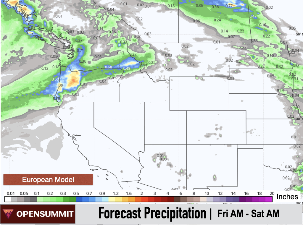
A similar pattern will remain in place Saturday with heavy rain expected across Oregon, Idaho, and Northwest Montana with lighter rain in Washington.
Moisture and energy will extend further east resulting in a better chance of showers/thunderstorms across Southern Montana, Northern Wyoming, and the Black Hills of South Dakota as well. Isolated afternoon thunderstorms will remain possible across Colorado, New Mexico, and Arizona.

Instability will increase across the Northern Rockies on Saturday as well, resulting in a better chance of thunderstorms from Eastern Oregon to Idaho, Montana, Wyoming, and South Dakota.

Forecast for Sunday:
On Sunday, heavy rain will continue across Oregon and Central/Northern Idaho, while the overall coverage of rain will expand south and east. Heavy rain will also be possible across Eastern Idaho, Northwest Wyoming, and Southwest Montana (including Yellowstone and the Tetons), and moderate rains will extend southward into Northern California including Tahoe.

Instability will be high across parts of the Interior Northwest and Northern Rockies on Sunday as well, resulting in a good chance of thunderstorms and locally heavy rainfall rates for many areas. Further east, instability will be even higher across the Black Hills of South Dakota where strong to severe thunderstorms are possible.

The Storm Prediction Center has highlighted a Slight (level 2 out of 5) Risk of severe weather over the Black Hills on Sunday with large hail and damaging wind gusts possible.

Extended Forecast
Outlook for Monday (6/13) to Tuesday (6/14):
The main storm system will swing across the Northern Rockies on Monday and a trailing disturbance will bring another round of precipitation to the Cascades on Monday and Northern Rockies on Tuesday.
A cold front will also be arriving with Monday's system and a significant cooldown is also expected with a changeover to snow expected across the mid to higher elevations of the Northern Rockies.

In fact, the potential is increasing for heavy snow in Glacier National Park and Northwest Montana, with accumulating snows also expected in mountain ranges throughout Montana, Idaho, and Wyoming and the higher portions of the Cascades.
Northern Utah and Northern Colorado could potentially see some light high elevation snow as well, though confidence is lower here.

Further south, gusty winds and dry conditions are expected across Arizona, New Mexico, and Southern Utah on Monday and Tuesday, which will result in elevated to critical fire danger.
Outlook for Wednesday (6/15) to Thursday (6/16):
A relatively quiet pattern is expected during the middle of next week with warmer temperatures for most of the West following the early week cooldown.
Outlook for Friday (6/17) to Friday (6/24):
A deep trough of low pressure is projected to set up just offshore of the West Coast during this period, resulting in cooler than average temperatures across Washington, Oregon, and California, while widespread above-average warmth should primarily be confined to the east side of the Continental Divide.

The Pacific Northwest and Northern Rockies will continue to be favored for wetter conditions as the door will be open for disturbances to track across these regions.
Also, medium-range models are projecting a monsoonal-like surge of subtropical moisture to work its way into the Four Corners region, even though mid-June is typically very early for the true onset of the monsoon.
Still, this will be something to keep an eye on, and at the very least, the potential is increasing for more widespread thunderstorms across the Four Corners region during this period.

Thanks so much for reading and have a great weekend! Next update on Monday (6/13).
ALAN SMITH
About Our Forecaster


