Western US Daily Snow

By Alan Smith, Meteorologist Posted 8 hours ago July 28, 2025
T-Storm Pattern Favors the Eastern Rockies & Interior Northwest
Summary
A trough-dominant pattern will continue across the West during late July and early August with Pacific disturbances bringing showers & t-storms to the PNW and Northern Rockies. The Eastern Rockies will also be favored for t-storms as easterly flow increased behind a cold front. The monsoon will continue in a weakened state with the main impacts in New Mexico & Eastern Arizona.
Short Term Forecast
Helpful Links:
Wildfire and Smoke Update:
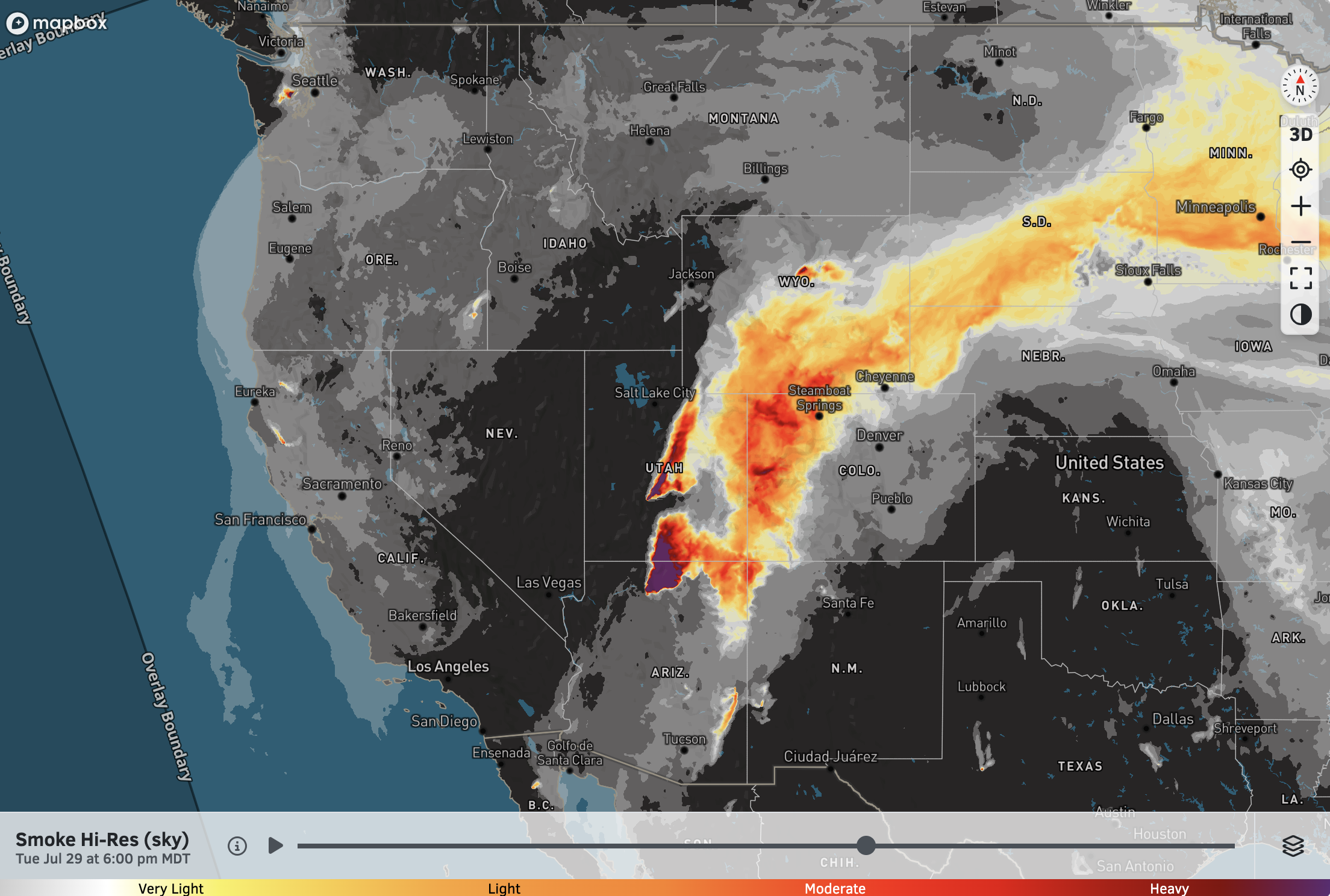
The two most active fires in the West right now are the Dragon Bravo fire on the north rim of the Grand Canyon in Arizona and the Monroe Canyon in South Central Utah, near Richfield.
South to southwest winds aloft will lead to heavy smoke across portions of Utah, Colorado, and Wyoming over the coming days.
High-Res Smoke (Sky) Forecast for 6 PM Tuesday:
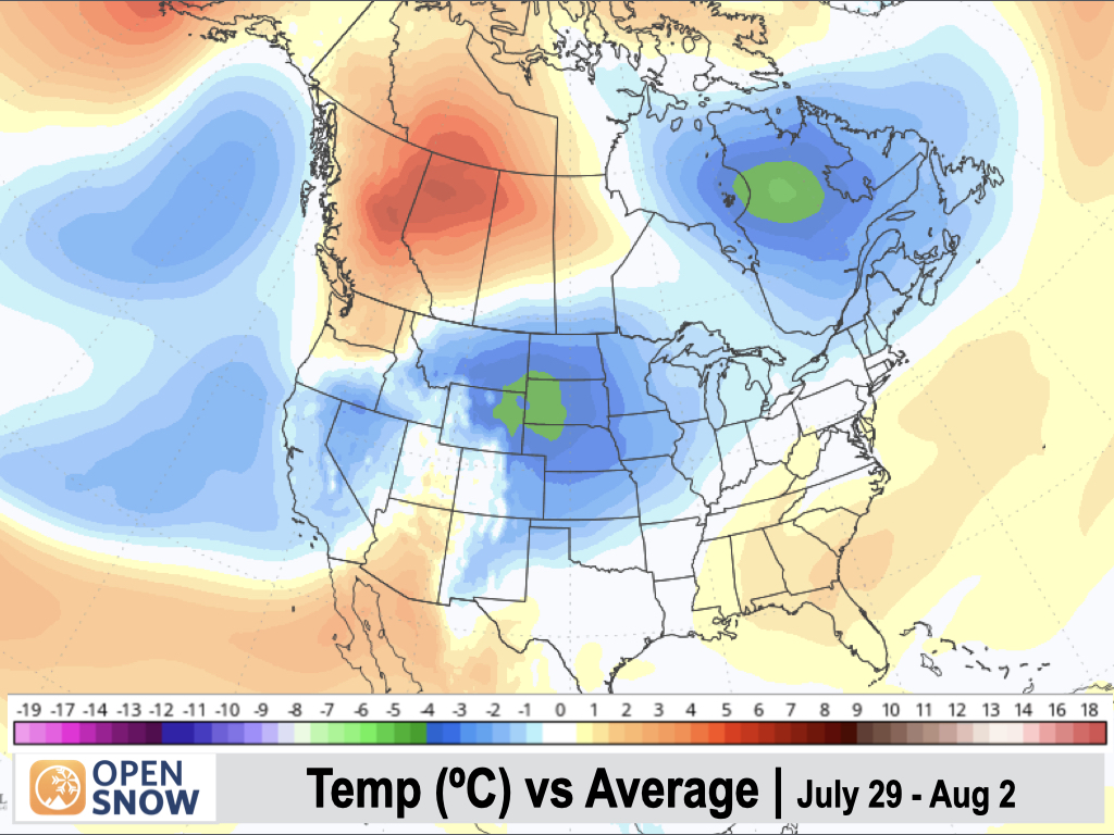
5-Day Temperature Outlook:
Temperatures will remain below-average across a large portion of the West, including the Sierra, Great Basin, and Northern and Eastern Rockies. Washington and Arizona will see above-average temperatures.
Tuesday (July 29):
A cold front will slowly work its way down the east side of the Rockies into Northern Colorado with abundant moisture and instability behind the front supporting scattered to numerous thunderstorms. Strong to severe thunderstorms are also possible east of the Divide in Wyoming, with large hail and damaging straight-line winds possible.
To the south, monsoonal moisture will be in place over New Mexico and Southern Colorado, where scattered to numerous thunderstorms can also be expected.
Areas along and east of the Divide from Montana to New Mexico could see heavy rainfall with strong thunderstorms. Flash flooding could not be ruled out anywhere in the green-shaded region, with the highest risk expected in New Mexico.
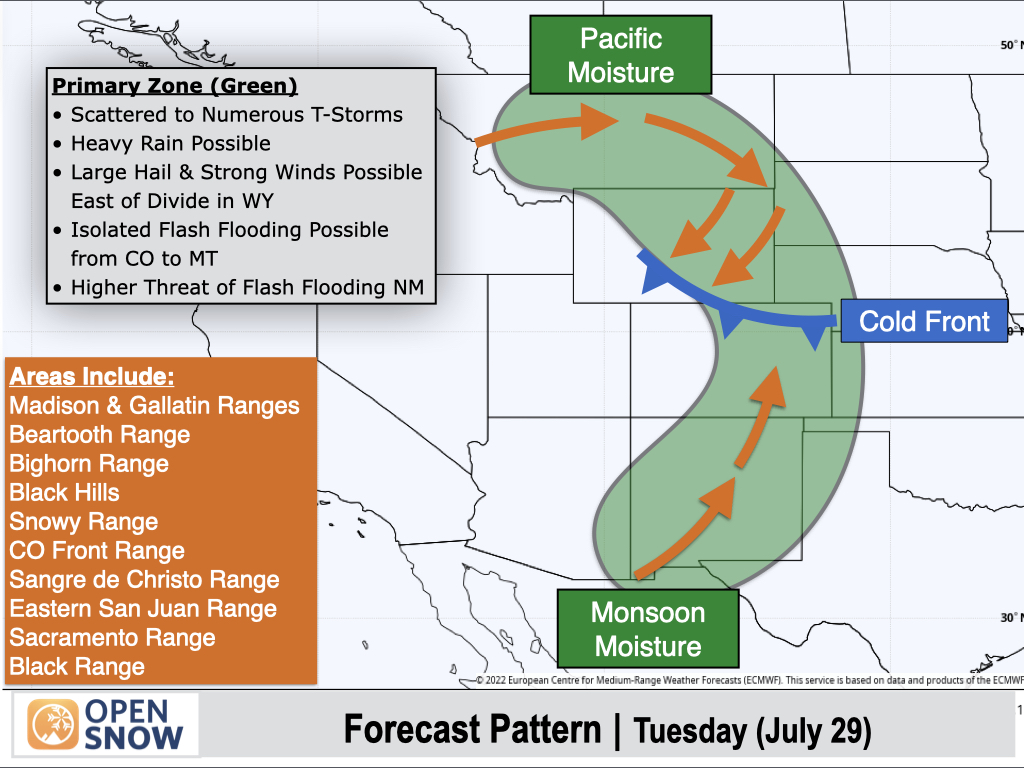
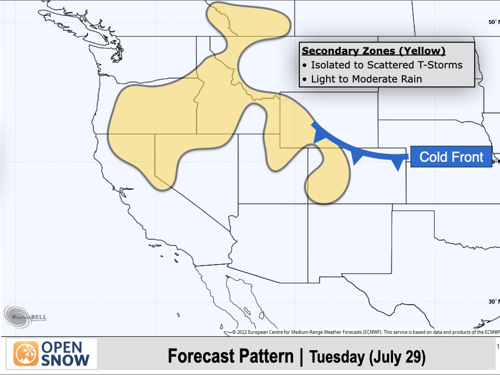
Areas west of the Divide in Colorado, Utah, and Wyoming will see isolated to scattered thunderstorms with light to moderate rain, as there will be less moisture to work with in these areas. Isolated to scattered thunderstorms can also be expected from Northern California and Oregon to Idaho and Northwest Montana.
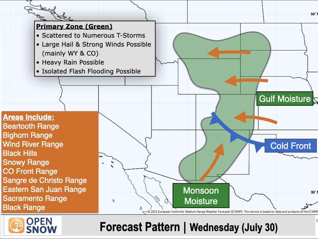
Wednesday (July 30):
The Eastern Rockies will again be favored for thunderstorms as a cold front slowly works its way southward into New Mexico.
To the north of the front, low-level easterly winds will support thunderstorms near and east of the Continental Divide. And to the south of the front, lingering monsoonal moisture will favor thunderstorms over Southern New Mexico and Eastern Arizona.
Strong thunderstorms will be capable of producing large hail and damaging winds (especially in Wyoming and Colorado), while isolated flash flooding couldn't be ruled out anywhere in the green-shaded region.
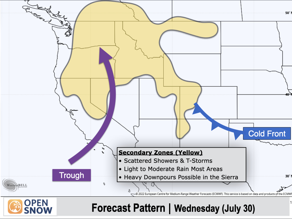
An inverted trough will move into the Far West with Pacific moisture supporting scattered thunderstorms across the Sierra Nevada Range, some of which will produce heavy downpours.
Scattered showers and thunderstorms will also develop across the Cascades and Northern Rockies, with most areas seeing light to moderate rain.
More isolated thunderstorms are also expected west of the Divide in Colorado, with lighter rainfall compared to areas near and east of the Divide.
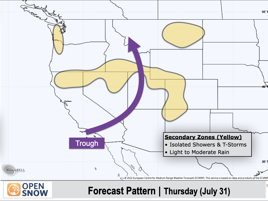
Thursday (July 31):
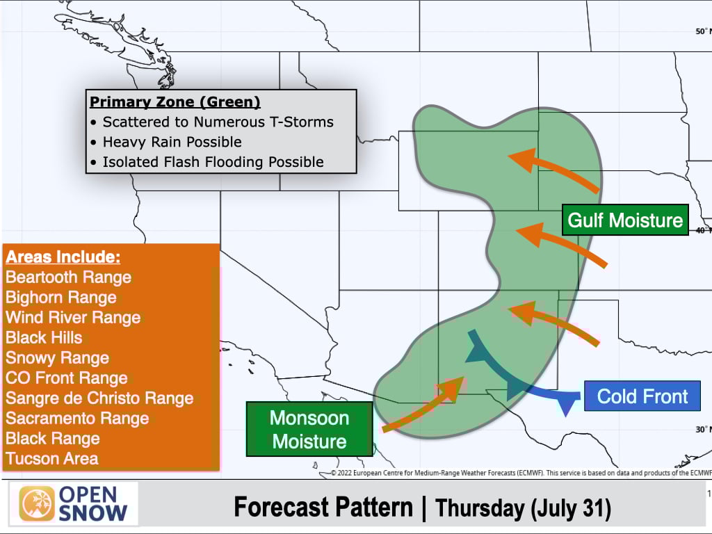
There are two primary zones to watch for Thursday.
First, the Eastern Rockies will be favored once again as a cold front continues to slowly work its way into Southern New Mexico. Monsoon moisture will remain in place south and west of the front, and will extend a bit further into Southern Arizona compared to prior days.
Areas in the green-shaded zone could see locally heavy rainfall with thunderstorms, including some potential for isolated flash flooding.
A second focus area is across the Interior Northwest from the Cascades to the Northern Rockies in response to the inverted trough moving inland. Abundant Pacific moisture for this time of year will fuel scattered to numerous showers and thunderstorms, some of which will produce moderate to heavy rain.
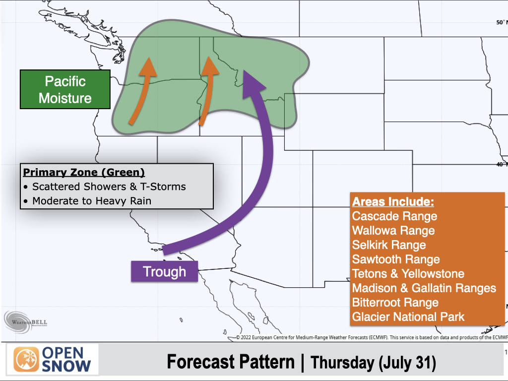
Elsewhere, areas shaded in yellow could see isolated showers or thunderstorms, with light to moderate rain.
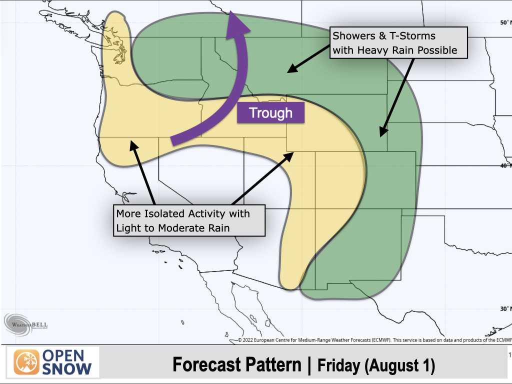
Friday (August 1):
A trough will slowly lift northward into Idaho with showers and thunderstorms favoring Washington, Northern Idaho, and Montana, while areas east of the Divide from Wyoming to Colorado to New Mexico will continue to see abundant moisture and thunderstorms as well.
Yellow-shaded areas will see lower moisture levels compared to green-shaded areas, with more isolated to scattered showers and thunderstorms expected.
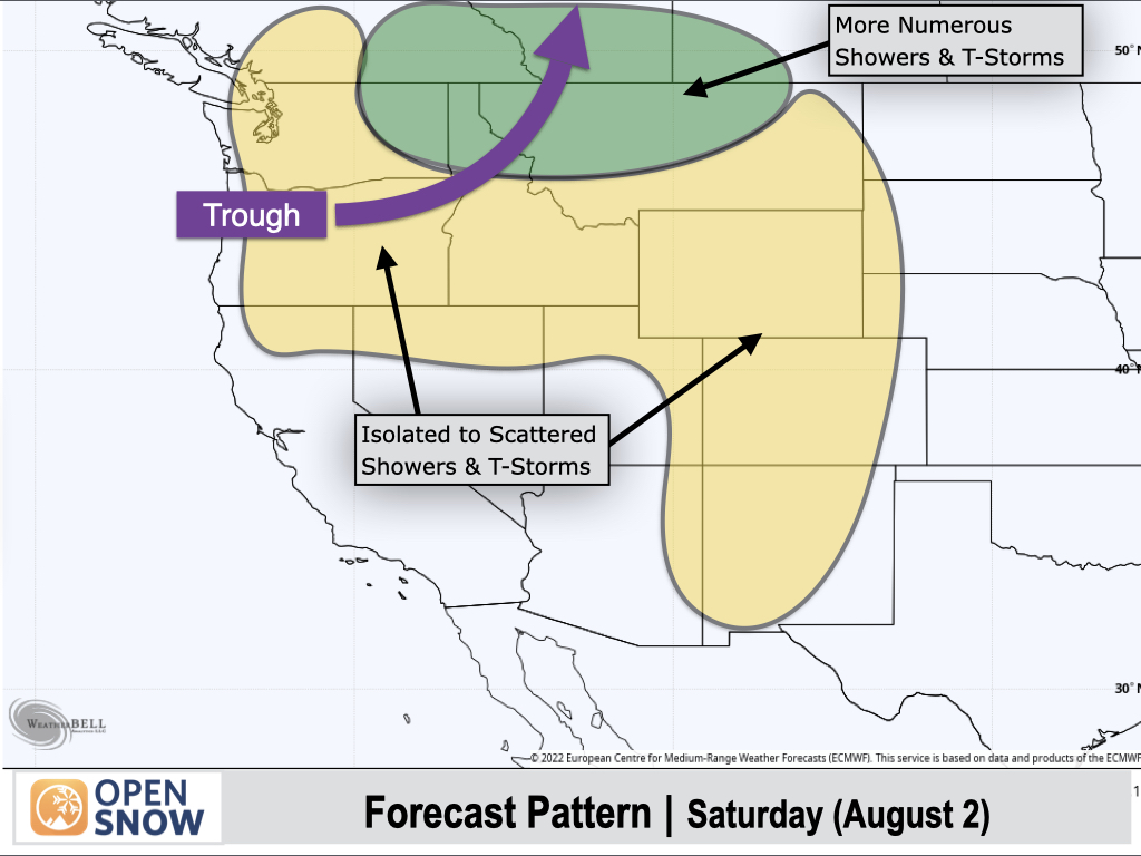
Saturday (August 2):
Northern-tier areas, including Northeast Washington, the Idaho Panhandle, and Northern Montana, will be the most favored for showers and thunderstorms, while yellow-shaded areas will be more favored for isolated to scattered activity along with lighter rainfall.
Extended Forecast
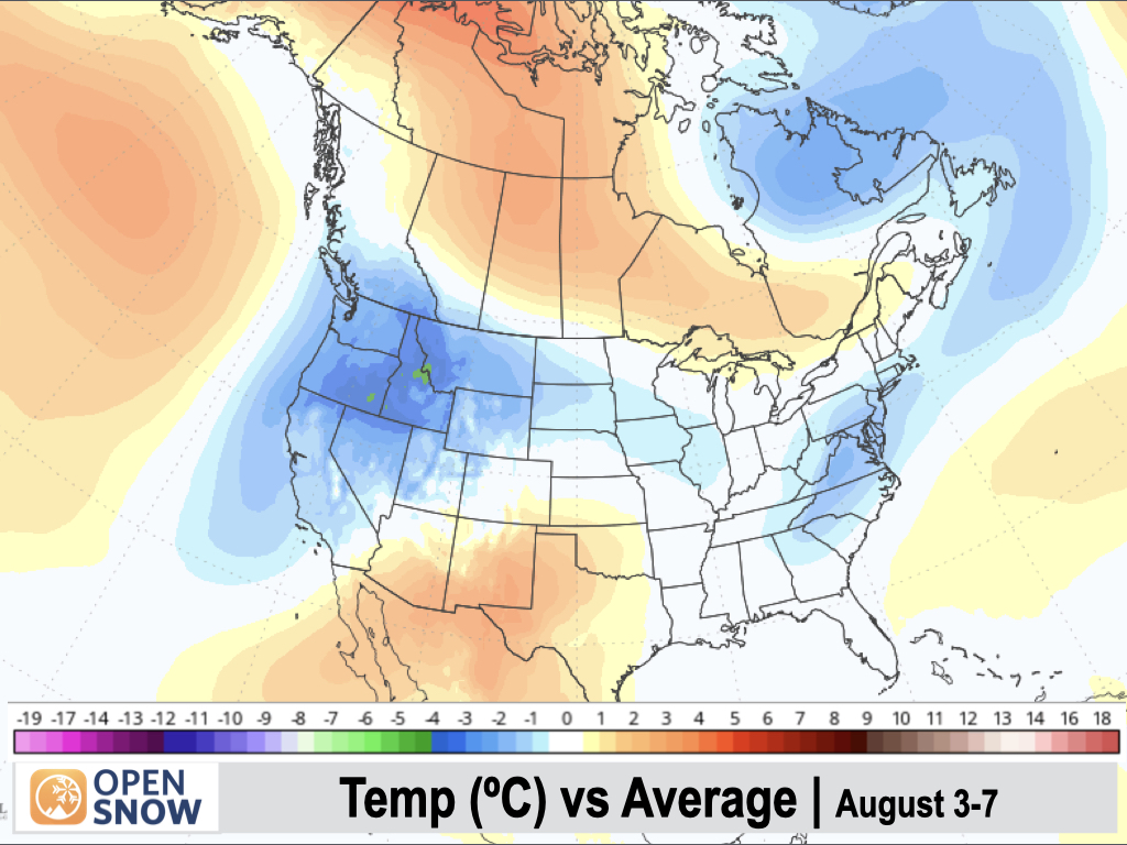
August 3-7:
Since my last post, the main trend in the medium to long range is for a continued weak monsoon with limited moisture for the areas dealing with large wildfires (Northern Arizona and Utah).
From August 3rd through 7th, models are in decent agreement with a trough-dominant pattern continuing across the Northwest and Northern Rockies with the potential for semi-frequent thunderstorms and respectable rainfall across these regions by early August standards.
The troughing will act to suppress the monsoon, however, with appreciable moisture remaining confined to Southern New Mexico and Arizona. Drier air is expected to push into Utah and Colorado with only isolated thunderstorm activity.
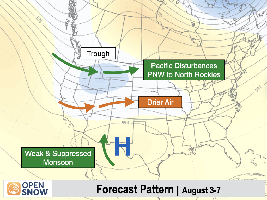
Temperatures are expected to be below-average across most of the West, except for Southern Arizona and New Mexico, where above-average temperatures are favored.
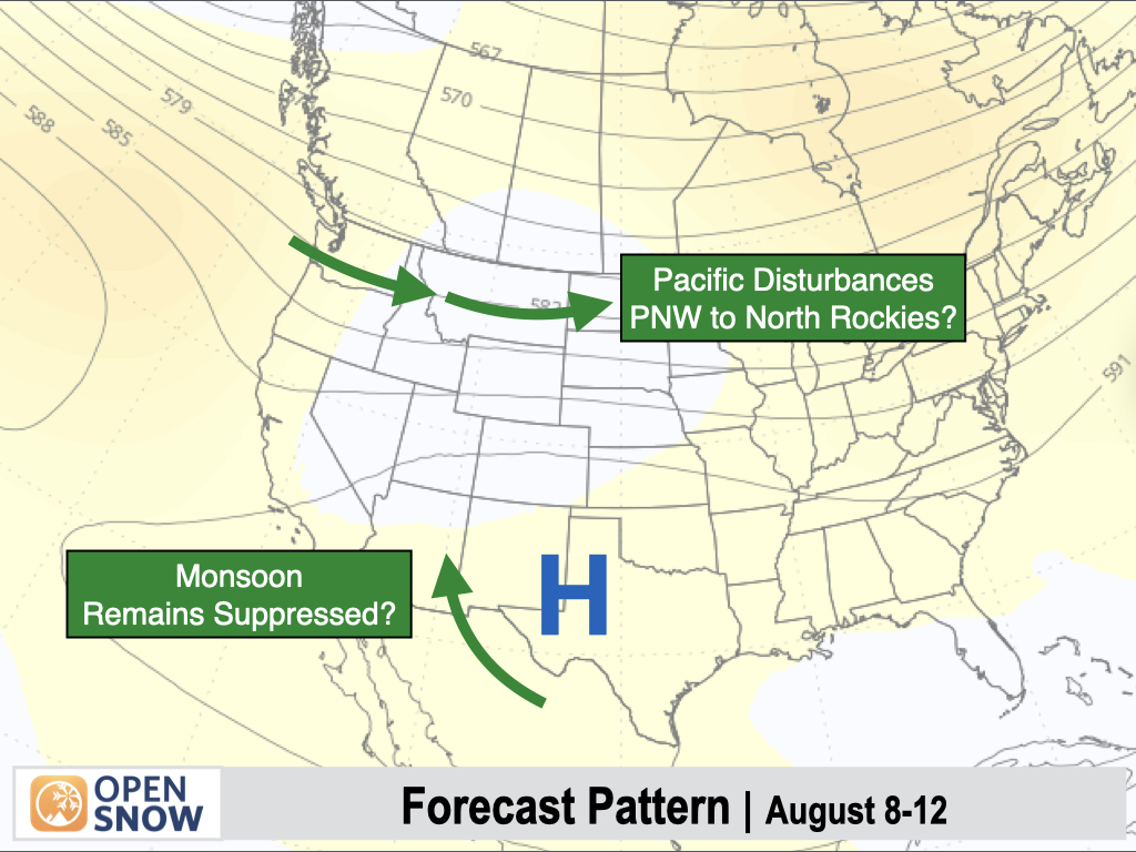
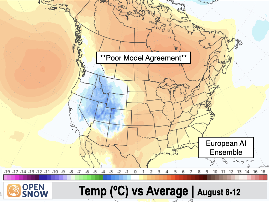
August 8-12:
Model solutions diverge during this period, with some models projecting monsoonal moisture to increase across the Southwest.
However, the European AI Ensemble Model (pictured below) is sticking with a "pattern of persistence" projection with frequent troughs moving across the Northern Rockies, and the monsoon remaining weak and suppressed to the south, closer to the Mexico border.
This model has correctly projected the weaker monsoon recently, while others have been projecting a stronger monsoon over time, only to back off as we get closer. So while confidence is still low, I wouldn't be surprised if this model has the right idea.
The Northwest and Northern Rockies may continue to see shower and thunderstorm chances in this pattern if the European AI solution pans out.
The European AI Ensemble Model (pictured below) continues to maintain below-average temperatures across much of the West, while other models are projecting above-average temperatures to return to nearly the entire West. We'll see how this looks as we get closer.
Thanks so much for reading! Next update on Wednesday (July 30).
Alan Smith
About Our Forecaster


