Colorado Daily Snow

By Joel Gratz, Founding Meteorologist Posted 9 years ago January 30, 2015
Snow Friday & Saturday
Summary:
- Friday - snow mostly for Wolf Creek & Durango, lighter to the north
- Friday night - same as Friday, though maybe a bit more snow to the north
- Saturday - south is still snow, likely a few inches for central & northern mtns
- Superbowl Sunday - dry and mostly sunny
- Next Monday through Thursday - light snow for northern mtns, maybe a pow day?
- Overall pattern still unfavorable during foreseeable future
Details:
On Thursday night, three inches of snow fell in Durango, Silverton, and likely Wolf Creek (their report isn't in as I type). North of there, just a few light snow showers or flurries fell out of the sky.
As of Friday morning, the center of the storm is spinning over the southern border of California, with lots of moisture pushing north into Arizona, New Mexico, Utah, and Colorado. The satellite image below shows the amount of water vapor in the upper half of the atmosphere (above about 18,000ft). This is important because many people look at a satellite image like this and think that all of this moisture and cloudiness is producing rain or snow.
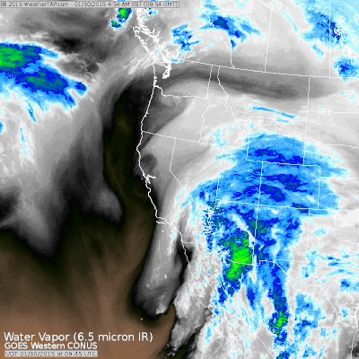
Water vapor satellite image on Friday morning. Source: Weathertap.com
In fact, though, you should look at the radar to see what precipitation is actually falling to the ground. The radar has its own problems in mountainous terrain as the hills can block the beam or the beam can overshoot the precipitation (more on that during another post). But the radar can be helpful despite these shortcomings. Looking at the radar below, for Friday morning, you can see that most of the precipitation is falling south of Colorado and in our very southern mountains.
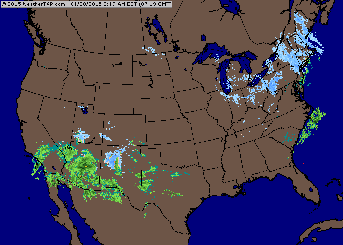
Radar animation on Friday morning. Source: Weathertap.com
Friday: Snow will focus on the southern mountains, namely Durango, Silverton, and Wolf Creek. These areas should see another 2-4 or 3-5 inches, with Wolf Creek likely seeing the higher amounts. North of these mountains, the wind direction will be unfavorable, so expect clouds and maybe a few flurries or light snow showers with minimal accumulation. There is a lot of moisture in the air, so if we can get some energy to lift the air in central and northern Colorado, maybe we see some actual accumulations, but this is a bonus in my mind.
Friday night: Mostly a carbon copy of Friday. Perhaps there is a bit better chance for an inch or two of snow in the central and northern mountains as some energy does push north through the state. Also, there will be a wind from the east in the northern and central mountains, so there could be a bit more snow along and east of the divide around Rocky Mountain National Park, Eldora, maybe some spill over to Winter Park (?), and perhaps down to Breckenridge. I only mention Breckenridge because an east wind gave them a sneaky six inches two weeks ago. Odds are low that we'll see this again, but I did want to mention it.
Saturday: I think all mountains will see snow accumulations on Saturday. More energy will push north across the entire state AND the wind direction will switch to blow from the west and northwest, which is favorable for the central and northern mountains. I upped the forecast to 1-3 inches for most mountains, with 2-4 or 3-5 for the southern mountains.
Overall, from Friday through Saturday evening, the freezing level will be rather high, perhaps around 7,500ft. It might lower in heavier snow and at night, and it might rise in lighter snow and during the day.
The best powder will be in southern Colorado at Wolf Creek, Silverton, and Durango on Friday afternoon and especially on Saturday. For the rest of the state, Saturday midday and afternoon will likely offer the best chance of a few inches of fresh. There is a LOT of moisture in the air, and this can always lead to some upside surprises in the snow totals, so I'll keep an eye on this but as usual I try to aim my forecast numbers to be realistic and err on the conservative side.
Sunday: The clouds should clear on Saturday night and Superbowl Sunday should be dry and sunny. The game starts at 430pm MST.
Monday through next Thursday: Northwest flow will bring clouds and light snow showers to the mountains along and north of I-70. The storm track is too far north for big accumulations, so I only have light amounts in the forecast each day and night. There's a chance some some of the time during Monday through Thursday is dry, and there's also a chance that a stronger wave of energy moves through during this time and drops a quick shot of heavier snow and makes for low-end powder day. Keep an eye on this and I'll keep you updated.
Longer range: I think it'll be dry and sunny next Friday to Sunday (February 6-8). The models keep trying to push energy and moisture through the ridge, but the general message is that the ridge over the west coast is still there and I don't see it moving anytime within the next 10 days to two weeks. Maybe we'll sneak out some snow from time-to-time with storms going over or under the ridge, so let's hope for this.
JOEL GRATZ
Announcements:
- Win a pair of Hestra Heli Gloves! Enter here: http://opsw.co/os-contest
- In case you missed the announcement, we added Canadian mountains and improved our forecast data. Details here: http://opensnow.com/news/post/new-features-canadian-mountains-added-forecast-data-improved
- Learn about where to find the best powder in Dr. Steenburgh's new book. My review: http://opsw.co/15KTdSk
About Our Forecaster
Joel Gratz
Founding Meteorologist
Joel Gratz is the Founding Meteorologist of OpenSnow and has lived in Boulder, Colorado since 2003. Before moving to Colorado, he spent his childhood as a (not very fast) ski racer in eastern Pennsylvania.
Free OpenSnow App


