Colorado Daily Snow

By Joel Gratz, Founding Meteorologist Posted 8 years ago November 30, 2015
Powder day in central & northern Colorado
Summary
Some areas have 6+ inches of new snow to start the day on Monday, and most of central and northern Colorado will see another 2-4 inches during the day, with perhaps another few inches on Monday night. Then Tuesday through Friday will be dry, with light snow likely on Saturday 12/5 and Tuesday 12/8. Another storm is likely during the following weekend.
The Colorado Daily snow is brought to you by…
Taos Ski Valley, New Mexico. Located just 50 miles south of the Colorado border, Taos Ski Valley is a mystical haven for 300+ inches of bone-dry powder stashes and some of the most untamed chutes, bowls and glades in North America. And with nearly half of all trails rated for beginners and intermediates, its unpolished charm and cheeky mountain rituals welcome anyone with a spirit of adventure. Learn more at SkiTaos.com/secrets
Details
After a lull in the storm on Sunday, snow picked back up on Sunday afternoon and Sunday night. This was caused by two waves of energy.
The first tracked from around Wolf Creek toward the northeast to Monarch and the Denver metro area (hence the snow during the Broncos game … good game!).
The second wave of energy tracked more west-to-east across central Colorado, focusing on the area around Aspen north to Vail and Beaver Creek.
Below I noted the snowfall from Sunday night and the 5-day storm total:
Wolf Creek: Unknown, 20
Beaver Creek: 8, 17
Monarch: 10, 16
Vail: 8, 15
Steamboat: 3, 12
Winter Park: 5, 12
Purgatory: 4, 11
Aspen/Snowmass: 6, 10
Copper: 2, 8
Some healthy totals on Sunday night, especially at Monarch, Aspen, Vail, and Beaver Creek. Wolf Creek likely saw decent snow as well, but they haven’t reported at the time that I’m typing this.
The storm that we’ve been enjoying since Thanksgiving is still close by, now swirling over Colorado and Wyoming:
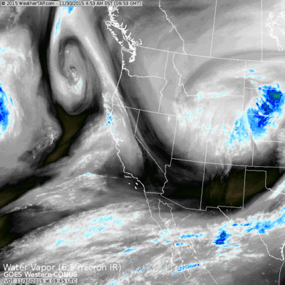
Source: Weathertap.com
During the day on Monday, a moist flow from the west and northwest will continue to bring snow to the northern San Juans (Telluride, Silverton), as well as the central and northern mountains. I have 1-3 or 2-4 inches in the forecast for most of these areas. I don’t think it’ll snow steadily all day, but rather the snow will come in waves.
Here is the forecast from the CAIC high resolution WRF model for Monday:
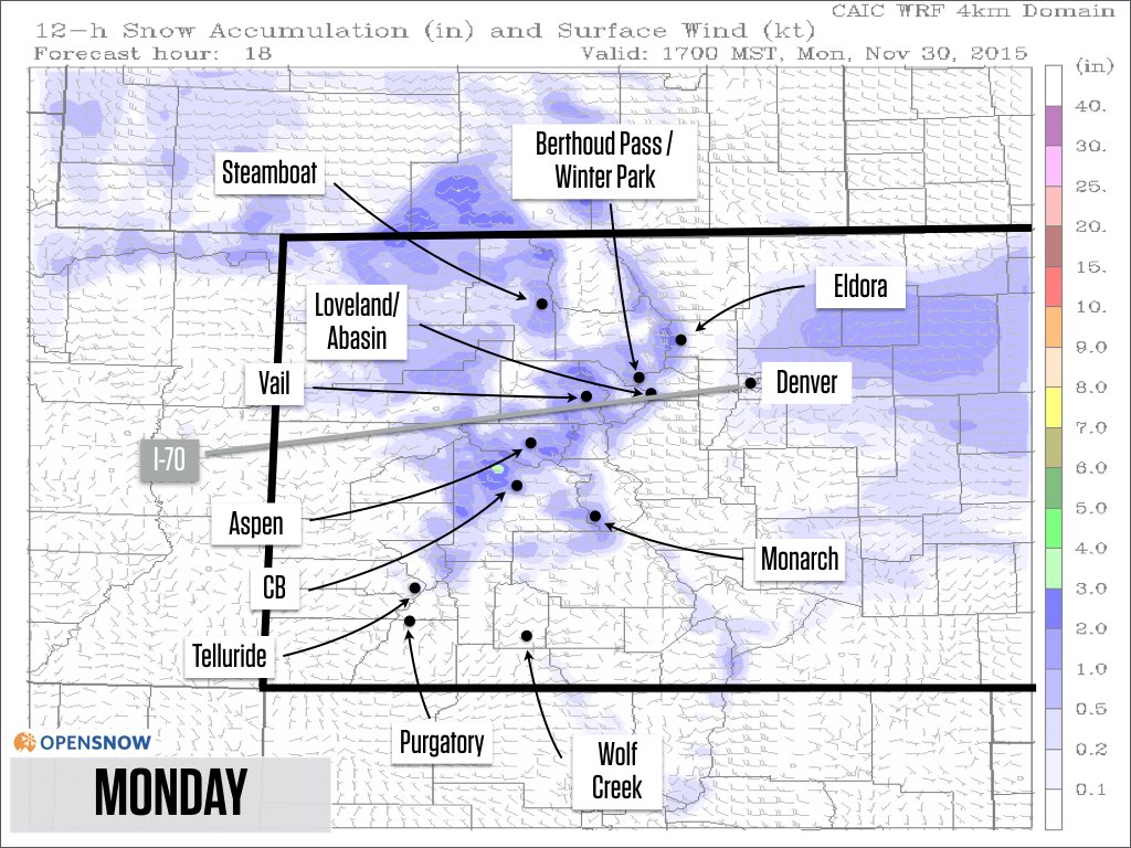
Source: CAIC / OpenSnow.com
On Monday night, the moist northwest flow will continue, so I kept a few inches of snow in the forecast especially for areas along and north of I-70. Moisture will be lacking, but the temperature (0-10F at mountain top), wind direction (northwest) and storm energy (vorticity maximum moving in from Wyoming) have me thinking that we could see some surprise totals. It’s worth watching the snow stake cameras at Steamboat, Winter Park, Loveland, Keystone, Breckenridge, Copper, and Vail to see if we’ll have another powder day on Tuesday morning.
Update at 1125am: the lack of moisture should keep snow totals down (lower than my forecast of 2-4) on Monday and Monday night in the central and northern mountains. I am on the hill now and it is snowing, but the flakes are tiny which is indicative of low moisture. Bummer, because all other factors were setup for a good northwest flow event.
Here is the forecast from the CAIC high resolution WRF model for Monday night:
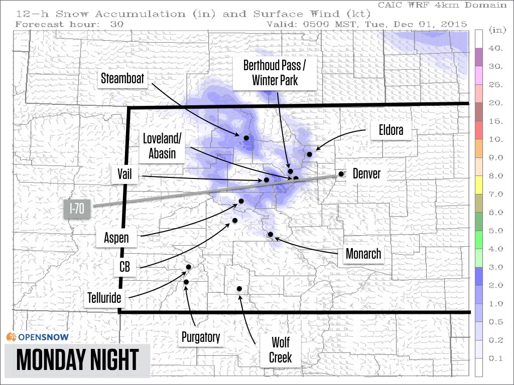
Source: CAIC / OpenSnow.com
From Tuesday through Friday, look for dry weather with temperatures warming each day.
Then we’ll see two weak storms, one on Saturday December 5th and another around Tuesday December 8th. I only put 1-2 inches in the forecast for each of these storms as both look meager at this point, but if that changes I’ll let you know.
Most models agree that we’ll get into stormier pattern around the weekend of December 12th, plus or minus a few days. I’ll keep an eye on this…
Enjoy the snow today on Monday and I’ll write another update on Monday night if there are major changes to the forecast, or otherwise on Tuesday morning.
JOEL GRATZ
About Our Forecaster
Joel Gratz
Founding Meteorologist
Joel Gratz is the Founding Meteorologist of OpenSnow and has lived in Boulder, Colorado since 2003. Before moving to Colorado, he spent his childhood as a (not very fast) ski racer in eastern Pennsylvania.
Free OpenSnow App


