News

By Sam Collentine, Meteorologist Posted 10 years ago December 2, 2013
Weather for this week - Dec 2 to Dec 6, 2013
The weather this week will be dominated by frigid temperatures and a multitude of snow across the western United States. An arctic airmass, which will bring below zero temperatures across most of the West this week, has already begun its march down from Canada into the Cascades of Washington and Oregon. Get prepared because this may be the coldest airmass that the Western US has seen in quite some time.
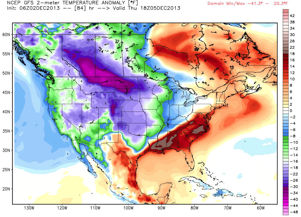
Temperature anomalies, according to the American GFS, as of midday Thursday. Source: WeatherBell.com
With the combination of a strong jet stream, cold temperatures, and abundant Pacific moisture, snow accumulations will range from 1 to 2 feet across much of the West and Upper Midwest through Thursday. To start, the Lake Tahoe region will receive 4 to 7 inches of snow beginning on Monday night and lasting through Tuesday night. This is great news for the areas struggling to find snow in the Lake Tahoe region. Get the latest details from our Lake Tahoe Snow Forecaster, Bryan Allegretto, in the Tahoe Daily Snow. Our attention now turns to Utah and Colorado where the best powder will be found this week.
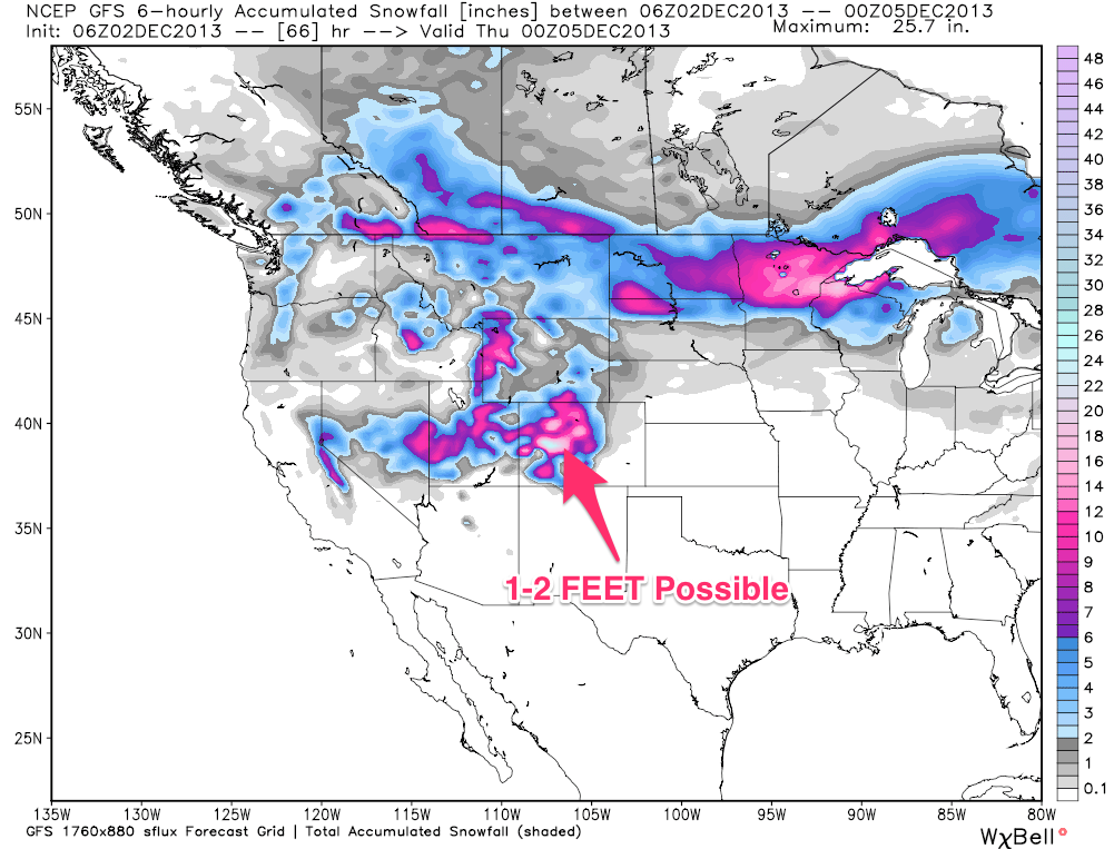
Total snow accumulations, according to the American GFS, for the Western US as of Wednesday afternoon. Source: WeatherBell.com, analysis by OpenSnow.
Our Utah Snow Forecaster, Evan Thayer, is forecasting BIG totals for Utah through Wednesday night. The Wasatch mountains north of I-80 will likely see 6 to 12 inches, the Wasatch south of I-80 and north of Provo 8 to 14 inches, and the mountains of central/southern Utah 10 to 20 inches. The central and northern mountains of the Colorado Rockies will also see similar totals. A strong upper level jet stream, along with a stalled cold front, will bring snow accumulations of 6 to 10 inches Tuesday night and 4 to 8 inches throughout the day Wednesday. As the upper level flow shifts Wednesday, the San Juans of southern Colorado will also join in with totals ranging from 8 to 12 inches. If you're looking for deep powder this week, the mountains of Utah and Colorado are where you want to be! We now turn our attention to the upper midwest where blizzard conditions will prevail throughout the middle of the week.
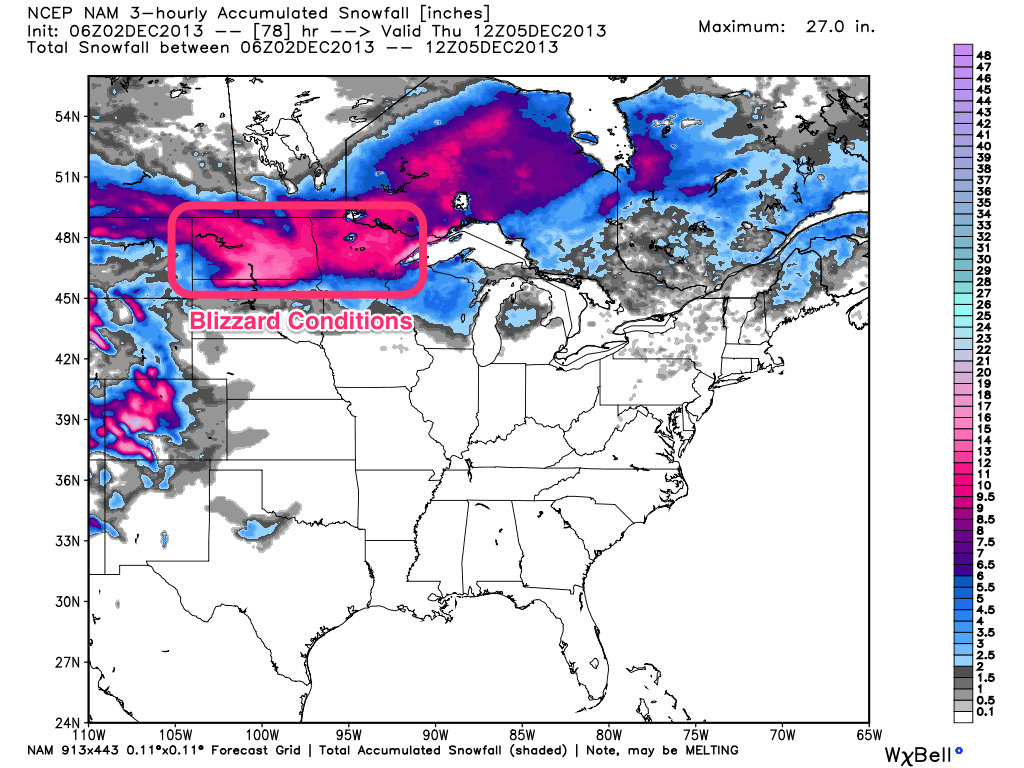
Total snow accumulations, according to the NAM, for the Upper Midwest as of Thursday morning. Source: WeatherBell.com, analysis by OpenSnow.
Accompanied by very strong winds and heavy snow, blizzard conditions will be present in many areas of the northern High Plains to the northern Great Lakes through the middle of the week. Expect up to a foot of snow for northern Minnesota and Michigan. Get the latest details from our Upper Midwest meteorologist, Andrew Murray, in the Upper Midwest Daily Snow as this storm develops.
In all, the western United States will be inundated with lots of snow and cold temperatures this week. What a great way to start our December!
Always remember to check our Powder Finder, forecasts for each mountain, and our Daily Snow posts throughout the week for more details.
SAM COLLENTINE
About The Author
Sam Collentine
Meteorologist
Sam Collentine is the Chief Operating Officer of OpenSnow and lives in Basalt, Colorado. Before joining OpenSnow, he studied Atmospheric Science at the University of Colorado, spent time at Channel 7 News in Denver, and at the National Weather Service in Boulder.
Free OpenSnow App


