New Zealand Daily Snow

By Mike O'Connor, Meteorologist Posted 1 year ago June 2, 2024
High and dry this week, but big potential next week
Summary
Kia ora everyone, Mike here from down under, proudly bringing you the very first OpenSnow forecast for Aotearoa, New Zealand. With just two weeks until opening day, Kiwi resorts will be left high and dry this week as high pressure dominates over the country. Next week, however, a potential duo of storms are picked to bring cold temperatures and possibly a heap of snow.
Short Term Forecast
Current Conditions & Opening Dates
The past month has been a cold one in New Zealand, due to a high-pressure system south of Australia stubbornly refusing to budge. This placed New Zealand in a persistent southwest flow that brought frequent cold fronts up the country and light shots of snowfall.
Last week, one of those cold fronts packed a lot more punch than the others, resulting in 10-15cm of fresh snow for the Southern Lakes, and up to 50cm for Canterbury and Ruapehu. Over the weekend, warm northwest winds have chewed away at this nice early snowpack, and now New Zealand's ski fields are a patchwork of snow, rock, and tussock.
The next couple of weeks will be crucial for snowfall and snowmaking as Mt Hutt and the Southern Lakes resorts plan to open on the 14th and 15th of June. Whakapapa and Turoa on Mt Ruapehu and Porters Pass plan to open on 28th June, while club fields elsewhere will open thereafter as conditions allow.
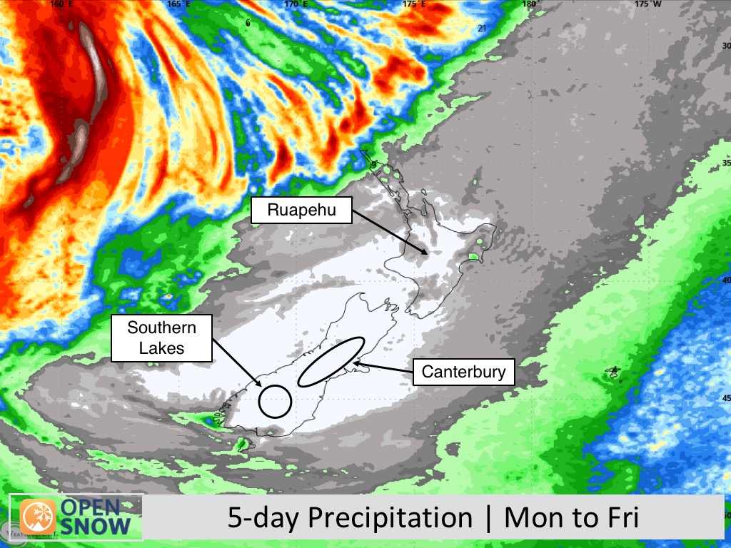
Forecast for Monday to Friday (3rd to 7th June)
It will be uncannily quiet for Kiwi resorts this week, as the high pressure that was south of Australia will dominate over New Zealand. It's not something you see very often, but all resorts will be fine and sunny Monday through to Friday, with not a drop of moisture expected (see the 5-day rainfall chart below) and only some high clouds at times. Strong southwest winds during Monday drop off on Tuesday and will remain light Wednesday through Friday. Overnight temperatures should dip below zero at most resorts for at least a time each night and allow some snowmaking to happen.
Extended Forecast
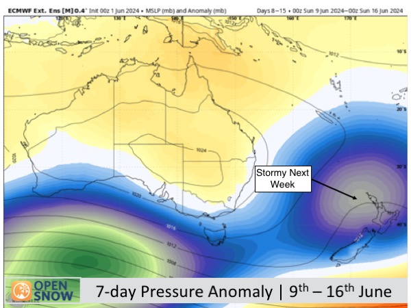
From Sunday 9th June, a storm in the Tasman Sea is likely to pass over New Zealand, with the potential to drag in cold air from the south and bring snow to the country over the following two or three days (Monday 11th to Wednesday 13th).
Long-range models expect another storm from the Southern Ocean will follow close behind and affect the country from about Thursday 14th to Sunday 16th June, with cold temperatures and snow also on the cards. This is a long way off so we'll keep a close eye on this one.
Thanks for reading. I'll keep these forecasts coming every Monday, Wednesday & Friday throughout the southern hemisphere season.
Michael O'Connor
About Our Forecaster


