New Zealand Daily Snow

By Mike O'Connor, Meteorologist Posted 1 year ago June 4, 2024
Dry pattern ends Sunday
Summary
With a week and a half left before Opening Weekend and little snow on the ground, resorts will remain dry Wednesday to Saturday as high pressure continues to dominate our synoptic charts. That all ends Sunday as a storm arrives from the Tasman Sea, with good early signs for snow the following days.
Short Term Forecast
Current Conditions & Opening Dates
About two weeks ago New Zealand received its first decent cold-season dump of snow. Up to 50cm was reported in Canterbury and on Mt Ruapehu, and up to 15cm in the Southern Lakes. We all had high hopes this early snowpack would stick, and even grow. Alas, the intervening weeks haven't been kind to this fledgling snowpack, and several strong northwest wind events have worn holes in it, leaving Kiwi slopes as a patchwork of snow, rock and tussock.
The next week and a half will be crucial for snowfall and snowmaking as Mt Hutt and the Southern Lakes resorts plan to open on the 14th and 15th of June. Whakapapa and Turoa on Mt Ruapehu and Porters Pass plan to open on 28th June, while club fields elsewhere will open thereafter as conditions allow.
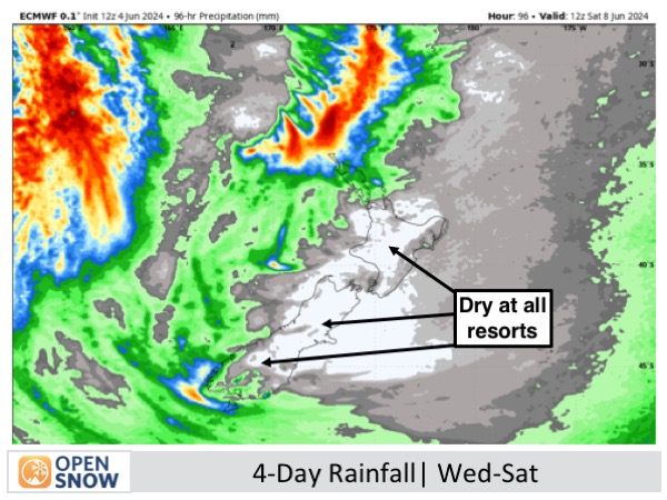
Forecast for Wednesday to Saturday (5th to 8th June)
High cloud covering the South Island on Wednesday will lead to more extensive cloud cover on Thursday as a weak front attempts to move up the country but is thwarted by high pressure dominating over the country. During this time, mild northwest winds will pick up, becoming quite brisk on Thursday, which will cause some damage to what little snowpack there currently is.
Friday and Saturday will be mostly sunny up on the resorts as high pressure continues to dominate and a weak west-to-southwest flow covers the country. However, significant moisture would have settled down in the valleys and basins, so there'll likely be low cloud cover or fog below the resorts.
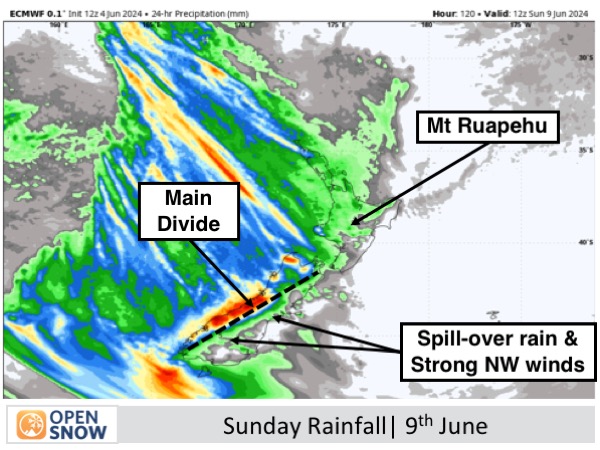
Forecast for Sunday (9th June)
High pressure finally moves away on Friday, allowing a storm in the Tasman Sea to pass underneath the country. Northwest winds will become very strong and rain hitting the Main Divide will spill over onto the resorts, again causing more damage to the snowpack.
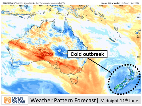
Extended Forecast
A cold southerly outbreak moves up the South Island Monday 10th June and over the North Island Tuesday 11th June. Early indications are that this should bring decent snowfall to Kiwi resorts, putting them in a much better position for Opening Weekend.
Thanks for reading. I'll keep these forecasts coming every Monday, Wednesday & Friday throughout the southern hemisphere season.
Mike O'Connor
About Our Forecaster


