Ski Utah Daily Snow

Heads up, there may be fresher snow! Read the latest Ski Utah Daily Snow

By Evan Thayer, Forecaster Posted 4 years ago September 16, 2019

Fall Temperature Roller Coaster

Summary

Autumn weather patterns are in full-swing as we will see a roller coaster of temperatures over the next 10 days. Snow will once again be possible on the high peaks as a series of cold front enter the region.

Short Term Forecast

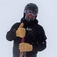
As promised, last week's storm delivered us our first widespread snowfall of the season in the high elevations.  Up to 4" of new snow fell in the highest elevations of the Wasatch with similar amounts in the Uintas.  I was up at the top of Collins Chair at Alta on Wednesday and took some photos including the one below: 

It was a surreal feeling as the temperature just a couple days earlier had been 90F in the valley.  Then, suddenly I was walking thru a legitimate snowstorm in the mountains.  Maybe just as weird, it all feels like a dream now.  This weekend, SLC managed to break 90F again on both Saturday and Sunday.  Well-above average temperatures just days after our first cool spell.  This type of temperature roller coaster is typical of Autumn in Utah and will continue for at least the next 10 days (and likely the next several weeks) as we transition seasons.  

Today (Monday Sept 16) we will see continued warmth with blustery conditions ahead of a trough that is pushing through California today.  This initial trough will bring us a chance for some showers late today and tonight, but its strength wanes as it moves inland.  We have a bit of a break and rebound in temps on Wednesday before a stronger trough pushes in late Thursday into Friday.  This system will bring a better chance for precip and we should see a more significant cooldown late in the week.  Temps on Friday could struggle to reach 60 in SLC with 40s in the mountains.  Snow will once again be a good possibility above 8500 feet or so.  

We should warm up again next weekend with pleasant weather.  

Extended Forecast

Models are split on the long range synoptic pattern.  The GFS and Euro were both showing a very strong ridge over the west coast to end September and begin October. However, the Euro has been backing away on this idea in recent runs.  In fact, it is now showing a better chance for below average temperatures.  We will have to wait and see which model is correct.  Either we have an "Indian Summer" in the GFS solution, or we continue to see periodic troughs and chances for mountain snow in the Euro solution.  

For those wondering about the upcoming winter.... There is still really nothing out there to give us any indication of how it will be.  There is lots of talk about the Blob of warm water in the Gulf of Alaska.  I'm not sure that it really has any impact on our weather patterns -- so I wouldn't worry about it.  Just cross your fingers and hope for the best.  Utah has a way of delivering! 

Evan | OpenSnow

About Our Forecaster

Evan Thayer

Forecaster

To Evan, 'The Greatest Snow on Earth' is more than just a motto - it’s a way of life. In 2010, he started Wasatch Snow Forecast as a way to share the best powder days with his fellow snow-lovers. Evan brings the same quality forecasts and weather discussions to OpenSnow and hopes you enjoy skiing/riding Utah as much as he does.

Free OpenSnow App