South America Daily Snow

By Luke Stone, Forecaster Posted 2 years ago May 31, 2023
Solid Storm Still On Track for the End of the Week
Summary
We are still working through this wet more than white period for the Andes in Chile/Argentina. The first wet storm will finish off cold with some snow and then a colder/stronger storm is on tap for the end of the week. Another significant storm is possible to end the weekend and last through the early part of next week.
Short Term Forecast
Temperatures remain warm across the high terrain in Chile/Argentina, with mainly rain except along the northern fringe of precipitation at upper elevations. Snow levels have been above most resorts the last 24 hours. A cold front will lower snow levels today, Wednesday, resulting in a period of snow and minor accumulations as precipitation tapers throughout the day. Minor accumulations are expected.
After brief break Wednesday night and most of Thursday, another storm arrives Thursday afternoon, with colder temperatures and significant snow.
Forecast for Thursday 6/1 - Saturday 6/3
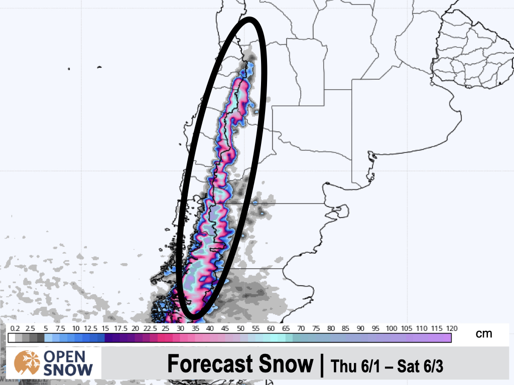
Most of Thursday should stay dry in the mountains of Chile and Argentina, before the next system arrives in the afternoon. Precipitation will likely start as rain, before transitioning to snow in the evening as a cold front spreads north. Snow will start to spread north of Pucon as well over the course of Thursday night. Snow should continue all day Friday and Saturday as well, before taping off overnight. While there will be some snow farther north, the heaviest will fall from Cerro Bayo south. Some higher elevation resorts farther north like Corralco, Nevada's de Chilean, and Cerro Catedral should do well also.
Below is the snow forecast from the European model for Thursday through Saturday night. Expect 20 - 60 cms above 1500m overall, with 10 - 20 cms below that. Generally, the heaviest precipitation totals will decrease as you move north.
Extended Forecast
Outlook for Sunday 6/4 - Thursday 6/8
After a short break during the day on Sunday, yet another system will bring more precipitation to the region. This looks like a prolonged event that could last through Thursday and maybe even Friday. This has the potential to bring up to .5 m of snow to the higher terrain, again with the biggest totals as ou move farther south. For now, let's get through storm number one, and I will dig into the details for next week later in the week.
Thanks for reading the South America daily snow! Follow me @lstone84 on Instagram to check out some new content I will be creating for the North American summer months. Let me know what you think.
About Our Forecaster


