South America Daily Snow

By Luke Stone, Forecaster Posted 1 year ago August 2, 2023
Record Breaking Heat and Rain
Summary
We saw record heat on Tuesday in northern Chile and Argentina, as another warm storm continued to the south. Some light snow will linger in the central and southern regions on Wednesday before things start to dry out. Some light snow is possible early next week but otherwise the region should stay mainly dry through the end of next week.
Short Term Forecast
Previously we talked about the jet stream bringing a warm storm through the central and southern mountains in Chile and Argentina. While the northern resorts stayed dry, they did not escape record breaking temperatures, as you can see in the map below.
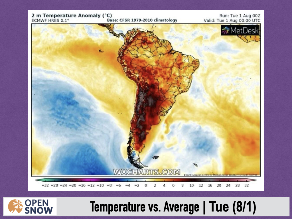
This map shows the temperature anomalies, which reached 10 - 16 degrees celsius above normal for a large area. Temperatures soared to over 38 degrees celsius, or over 100 degrees Fahrenheit. In Winter. Here are some high temperatures from yesterday, courtesy of @ThierryGooseBC on Twitter.
38.7°C Vicuña
38.7°C Chiguinto (1,063 m)
38.2°C Altar de la Virgen (1,385 m)
37.8°C Casa Rosada (1,292 m)
35.7°C Monte Patria-Chilecito
Forecast for Wednesday 8/2 - Sunday 8/6
Today has a chance to be even warmer than yesterday, and the warm air will stick around for several more days. I don't expect much of a cool down until the weekend at the earliest. I am not expecting any storms during this period either, as an upper level area of high pressure settles in over the region.
Forecast for Monday 8/7 - Tuesday 8/8
There isn't a whole lot going on early next week as well. A very weak storm may have enough moisture to bring light snow to the northern resorts, like Portillo and Los Penitentes. However, this does not look like any more than 4 - 8 cms, at best. This would occur between Monday afternoon and Tuesday.
Extended Forecast
Outlook for Wednesday 8/9 - Sunday 8/13
We are still looking at the end of NEXT week for the next storm. Models remain in disagreement on the timing, strength, and track of this storm, unfortunately. The models have a storm arriving sometime between Wednesday night (8/9) and Thursday night (8/10). There are some signs this will take a more northerly track and bring more significant impacts to the northern resorts, which would be nice. Further, it looks like temperatures will start out warm and only cool of marginally. This storm is still more than a week out though, so as always, we'll home for some positive trends in the coming days.
Thanks for reading the South America daily snow! Follow me @lstone84 on Instagram to check out some new content I will be creating for the North American summer months.
About Our Forecaster


