South America Daily Snow

By Luke Stone, Forecaster Posted 1 day ago July 21, 2025
Looks Like Meat's Back On the Menu Boys
Summary
After an extended dry stretch for the majority of resorts in the Andes, it finally looks like a more active pattern will return with significant snow likely. This period begins around Thursday night, but we will see a smaller teaser storm Monday through Tuesday morning first. A stronger and longer-duration storm is possible starting next weekend.
Short Term Forecast
A lot has changed in the forecast over the weekend, and mostly for the positive. In addition to increasing confidence in the late-week storm, it appears more likely that an active pattern will persist into next week. A shorter duration and smaller-scale storm should bring a quick burst of snow today (Monday) into Tuesday morning as well. All of this is great news, but there are some caveats.
Let's start wth our first storm, which moved in last night as a weak area of low pressure crossed the Andes.
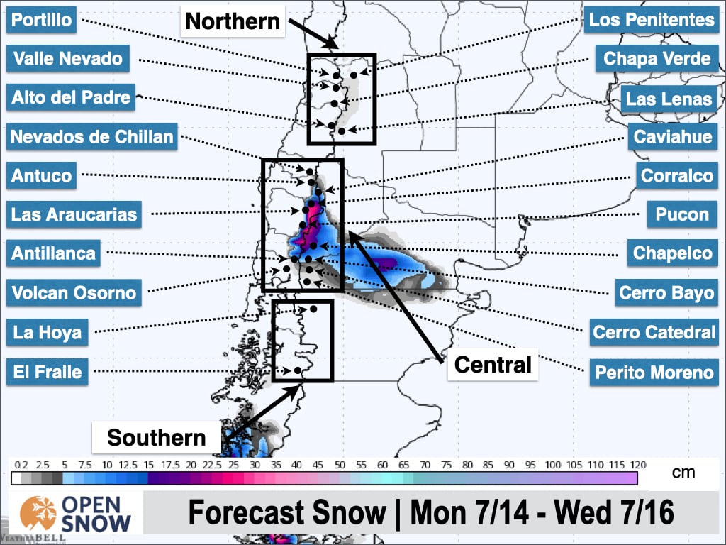
There should be enough moisture and lift for a narrow band of moderate to heavy precipitation to develop in the central zone, between approximately Volcan Osorno and Caviahue. We could see some snow showers farther north/south of that general area. Snow levels are a bit high, so we could see some mixing at lower elevations. However, mid-mountain and above should see 5 to 20 cm of snow. Below is the latest snow forecast from the American model through Tuesday.
Monday night through Wednesday night will bring a break in the action with temperatures on the rise as a ridge briefly moves into the region. The next system will already be forming, though, and making its way toward the Chilean coast. Precipitation is expected to begin in the southern Andes as early as Wednesday night, around Cerro Castor.
This is a larger storm overall, with more widespread impacts, in part thanks to a healthy atmospheric river. We can see this in the GIF below, which shows the precipitable water anomaly.
Below is the same figure, zoomed in to show where the anomalous moisture is located in relation to the resorts.
This atmospheric river will provide abundant moisture but will also be accompanied by warmer temperatures from the north, as is often the case with these types of events. Precipitation is expected to move into the southern region on Wednesday night and then the central region on Thursday, continuing through Saturday. Snow levels should be around or just below base elevations at the onset of precipitation, and then fall a bit lower on Thursday night.
As a result, I don't expect this to be low-density snow, but with low snow depths in many areas at the moment, dense snow is welcome. Let's take a look at the potential snow totals for this late-week storm.
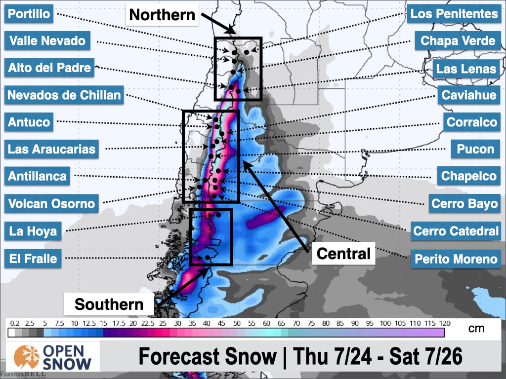
As you can see in the figure above, and has often been the case lately, there is a fairly sharp cutoff in precipitation/snow totals. This ensemble snow forecast from the American model shows significant snow at resorts like Corralco and Nevados de Chillan, with solid totals as far north as Las Lenas and Alto del Padre, while Valle Nevado, Three Valleys, and Portillo are expecting little to no snow based on this model run.
The other models show a fairly similar setup for this storm, which allows for a slight northerly shift in the track that would bring significantly more snow to the north. The latest guidance shows around 25 to 50 cm for the Chilean resorts in the northern zone, deepest around Chillan and Corralco, with 15 to 40 cm on the Argentinian side. As mentioned, totals should drop off sharply to the north, but Las Lenas could manage around 5 to 15 cm. I will fine-tune these snow totals on Wednesday and Friday as well.
Later in the weekend, a potentially larger and longer-duration storm is possible, with the latest model runs favoring the northern zone. This is still about a week away, so confidence is certainly not too high at this time. However, the models indicate the potential for a widespread .5 to 1.25 m from this storm in the northern zone and northern part of the central zone, with significant totals on the Argentinian side as well.
Below is the latest upper-level pattern forecast from the American model. You can the next low-pressure system, followed by a second system right on its heels, moving through the Andes from Sunday through Wednesday of next week.
Not surprisingly, the models have a second, and even stronger, atmospheric river penetrating the Andes and lingering through Wednesday. I am very cautiously optimistic that this could be a major snow event, especially in the north, but the latter part of this storm is nearly ten days out in fantasy land. Needless to say, I will be watching this storm cycle very closely with a possible chase in mind.
Extended Forecast
Way out beyond fantasy land, the ensembles do show the potential for the active pattern to continue. As always, in this time frame, just seeing the possibility of stormy weather rather than obvious signs of high pressure is nice to see.
Next post on Wednesday.
Thanks for reading the South America Daily Snow!
Luke Stone
Forecaster, OpenSnow
Announcements

NEW: Forecast Range Graphs

You can now view individual forecasts from global and regional high-resolution weather models in OpenSnow. This includes forecasts from the GFS, ECMWF, HRRR, and ICON models, as well as the OpenSnow blend.
The graphs give you a behind-the-scenes look at the forecast and make it easier to see if the forecast models are in tight agreement or if there is a wide range of potential outcomes over the next 10 days.
Note: This is currently only available in the OpenSnow iOS app and website (OpenSnow.com). Android will be available soon.
Getting Started
- Go to any location screen.
- Scroll down under "Weather" or "Snow Summary".
- Tap "View Interactive Chart" in the app.
- Adjust the model, timeframe, or data view.

Why is the Forecast Range helpful?
Understand if there is high or low confidence in the forecast. If all models show a similar forecast, there is higher confidence in the forecast, and vice versa.
Dig into the details. If you have experience looking at weather model data and trust certain models or higher-resolution models, you'll be able to isolate your favorite data.
View → Forecast Range Graphs
About Our Forecaster


