US & Canada Daily Snow

By Joel Gratz, Founding Meteorologist Posted 5 years ago September 30, 2019
Storm drops 1-2+ FEET of snow. More coming?
Summary
A strong September storm delivered more than two feet of snow to the northern Rockies from September 27-30. Locations as far south as California and Utah also measured a few inches of fresh. While these September storms generally have little correlation to the rest of the season, they are still fun to see! Coming up, another system should bring snow to the northern Rockies around the first weekend of October.
Short Term Forecast
Current Snowstorm from Fri, Sep 27 – Mon, Sep 30
I saved this radar animation from Sunday morning (Sep 29) because it shows snow falling over a large area of the northern Rockies, extending west to Washington and south to Idaho, California, Wyoming, and Utah.

Temperatures during the peak of the storm are running 20-30 degrees Fahrenheit colder than average, centered over western Montana. In other words, temperatures are plenty cold enough for snow to fall!

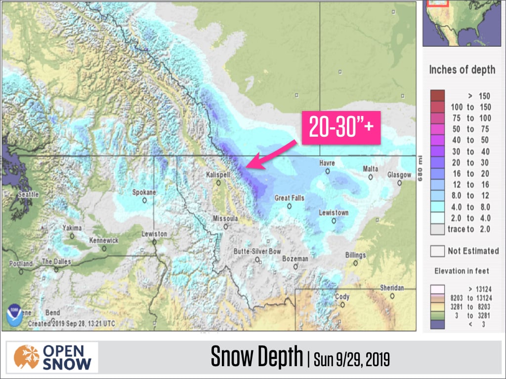
Total snowfall from Fri, Sep 27 – Sun, Sep 29 has been the deepest just east of Montana’s highest peaks, where an east wind has led to multiple days of snow piling up. The estimated snow depth (amount of snow on the ground) as of Sunday, September 29th is up to 20-30+ inches in the most fortunate mountains of Montana.

The map above also shows a healthy 10-20+ inches farther north into Alberta, Canada, and that amount is corroborated by this snow stake image from Castle Mountain (where the snow stake says to "call in sick" for this amount of snow, and I agree!).

The storm will spend one more day delivering snow to the northern Rockies, with an additional 3-10 inches accumulating later on Sun, Sep 29 through Mon, Sep 30, mostly in northern Montana and Alberta, Canada, though some snow showers will extending farther south into the central Rockies of the United States.

Forecast for Tue, Oct 1 – Wed, Oct 2
Most areas will be between storms during the middle of the week. A piece of the storm that brought the significant snow to Montana and Canada will cross Wyoming, delivering just a few inches of accumulation.

Forecast for Thu, Oct 3 – Sun, Oct 6
The next system should head into western Canada later this week and then sweep into the northern Rockies over the weekend.
An early look at the snow forecast shows top-end amounts in the range of 6-12 inches for British Columbia, Alberta, and Montana/Idaho, with lower amounts for Wyoming, Utah, and Colorado. These are respectable totals for early October, but unless something massive changes in the forecast models, this upcoming storm will be far less impactful than the current storm.

Extended Forecast
Outlook for Mon, Oct 7 – Fri, Oct 11
When we look at forecasts beyond about one week, it’s most reliable to look at the prediction for above or below-average temperatures and to use this prediction as a guide for where storms might track.
In this case, looking out to the second week of October, most forecast models agree that the potential for the coldest air (and therefore the best chance for snow) should be over the northern Rockies from Washington state through Idaho, Montana, and north into British Columbia and Alberta, Canada.

Thanks so much for reading, and please continue to look for early-season updates each Monday morning to build our excitement for a (hopefully) snowy season ahead.
JOEL GRATZ
Announcements
See where to chase powder → https://opensnow.com/dailysnow/chase
Find your local forecast → https://opensnow.com/explore
Download our free mobile app → https://opensnow.com/about/app
About Our Forecaster


