Western US Daily Snow

By Alan Smith, Meteorologist Posted 3 years ago September 1, 2021
California fire woes, wet pattern for the Southwest
Summary
Large wildfires continue to impact California this week, including the Caldor Fire which is impacting the South Lake Tahoe region. Meanwhile, a surge of monsoonal moisture in conjunction with the remnants of Pacific Hurricane Nora will result in widespread showers and t-storms along with the potential for flash flooding across the Four Corners states.
Short Term Forecast
Numerous large fires are burning across California, resulting in widespread smoke and air quality issues along with threats to local communities.
The Caldor Fire has forced an evacuation of the entire town of South Lake Tahoe (22,000 people). As of Tuesday, the fire had burned across portions of Sierra-at-Tahoe Ski Resort and is threatening other ski resorts in the area such as Kirkwood and Heavenly, not to mention large numbers of homes and structures.
Unfortunately, windy conditions are expected to continue on Wednesday and to a lesser extent Thursday, which along with low relative humidity will result in high spread potential.
Here is the wind gust forecast map for Wednesday morning:

Winds are expected to decrease to a greater extent on Friday (good news), but daytime relative humidity values will continue to be quite low with poor overnight recovery (bad news).
Smoke from the numerous fires across California will continue to impact air quality across California, Nevada, and downwind states.
On Wednesday, the smoke plume will extend northeast into portions of Utah, Eastern Idaho, and Wyoming due to southwesterly winds (from the southwest) aloft. Smoke will also impact areas east of the Continental Divide in Wyoming and Colorado, including Denver Metro.
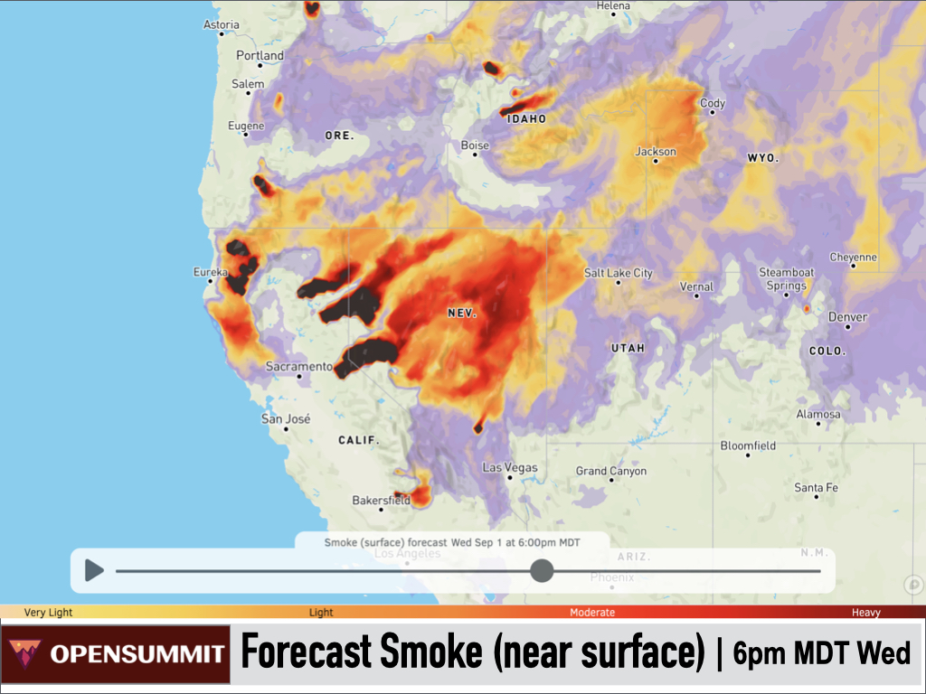
Thursday's pattern will be similar with just a slight southward shift in the smoke.

Heading into Labor Day weekend, winds aloft will start to shift to west/northwest resulting in a southward shift in smoke, with higher impacts over Utah, Colorado, and Northern Arizona and New Mexico.

Smoke and fire issues aside, a fairly active weather pattern is in place over the Intermountain West during the middle part of this week.
A large trough of low pressure is located over the Western U.S. with multiple embedded disturbances.

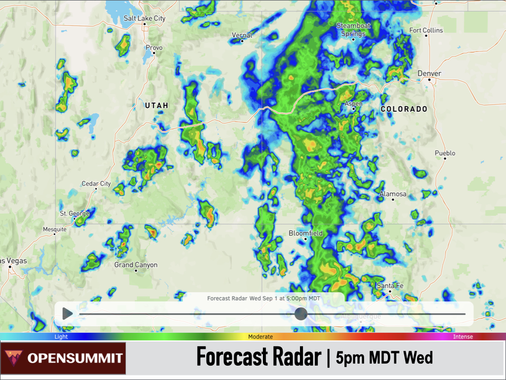
Southwest flow and abundant energy from this pattern is interacting with monsoonal moisture along with the remnants from Pacific Hurricane Nora to result in wet conditions and even a flash flooding risk across parts of Arizona, Utah, Colorado, and New Mexico.

Ongoing showers and thunderstorms across Utah and Arizona on Wednesday morning will spread into Western/Central Colorado and Northern/Central New Mexico on Wednesday afternoon with widespread wetting rains expected.
After an active middle of the week, the pattern will quiet down heading into Labor Day weekend with a weak ridge of high pressure building over the Western U.S.

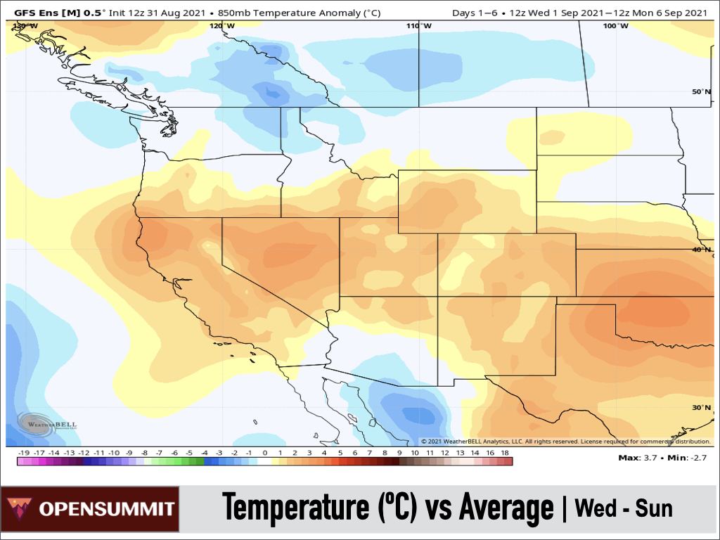
Despite the mid-week rainfall, temperatures over the next 5 days will generally be above average across the Central Rockies, Great Basin, and California, and near to below average across the Northwest as well as Southern Arizona.
Forecast for Wednesday, September 1st
A wet day is in store throughout the Four Corners region with the heaviest rainfall expected across Southern Utah, Eastern Arizona, Western Colorado, and Northern/Western New Mexico. Only isolated showers/t-storms can be expected farther north into Wyoming and perhaps Montana.

Forecast for Thursday, September 2nd
Scattered showers and thunderstorms can be expected again across the Four Corners region, possibly starting early in the day. Meanwhile, a disturbance moving across the Northern Rockies will produce some shower/thunderstorm activity across Montana, Idaho, and Wyoming on Thursday afternoon and Thursday night.

Forecast for Friday, September 3rd
Shower and thunderstorm activity will linger across the Northern Rockies on Friday morning, and perhaps into Friday afternoon east of the Continental Divide. Monsoonal moisture will remain in place across the Four Corners states with another solid round of afternoon showers and thunderstorms expected.

Forecast for Saturday, September 4th
Conditions will dry out across the Northern Rockies, while the Four Corners region will see another round of afternoon thunderstorms with less coverage compared to prior days. A fairly strong storm system will also impact coastal portions of British Columbia, with some rain extending south onto the Olympic Peninsula and to a lesser extent the Washington Cascades.

Forecast for Sunday, September 5th
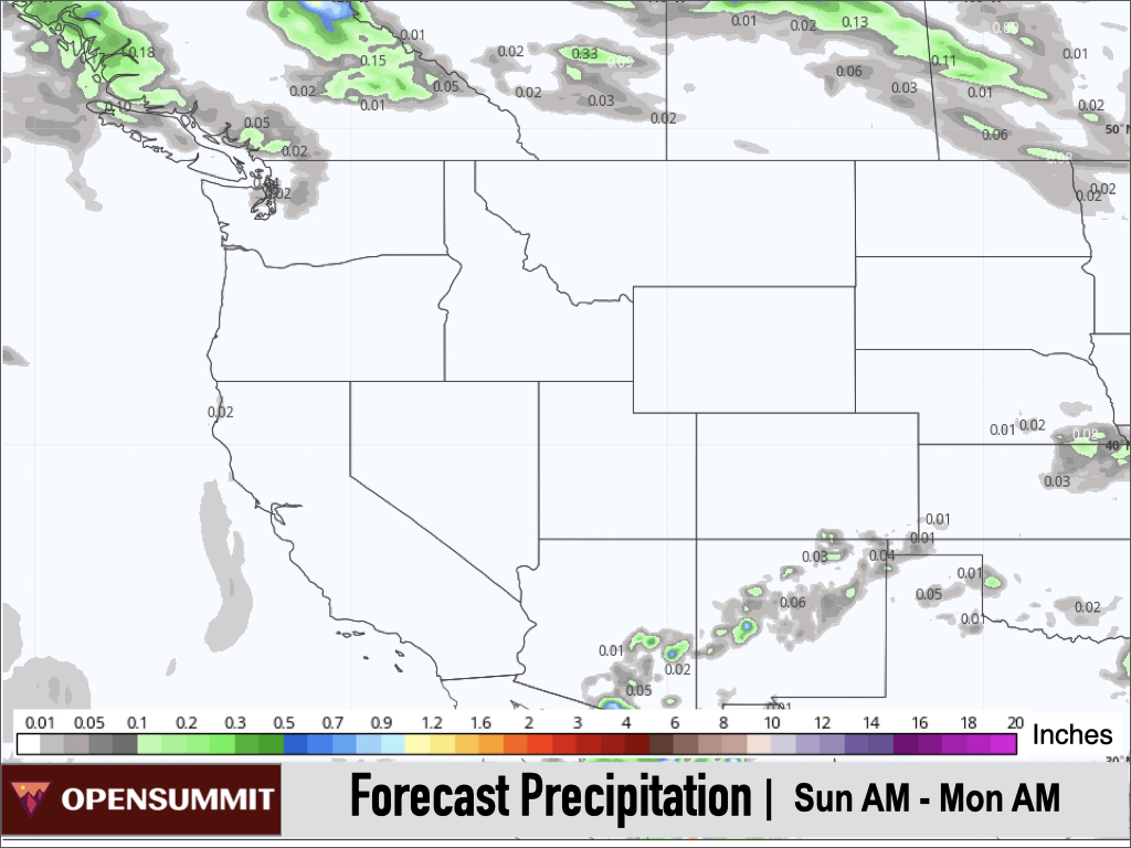
A drying trend is expected with a weakening monsoon and afternoon thunderstorms mainly confined to Arizona and New Mexico. A few light showers are also possible across the North Cascades.
Extended Forecast
Outlook for Mon, Sept 6th - Fri, Sept 10th
A relatively quiet pattern is expected next week with high pressure, above-average temperatures, and a continuation of fire and smoke issues across California and downwind locations.
A weak monsoon will largely keep afternoon thunderstorm activity confined to Arizona and New Mexico with only a minor threat farther north in Utah and Colorado. The Northwest and Northern Rockies could possibly see some showers late in the week.

Heading into the weekend of September 11th-12th, there are some hints of a more unsettled pattern setting up with shower chances across the Northwest and Northern/Central Rockies, but confidence is low at this time.
Thanks so much for reading! Next update on Friday (9/3).
ALAN SMITH
P.S. Could you take a moment to rate the OpenSummit app with a 5-star review? These reviews help us to be seen by more people, and a larger audience provides the support needed for us to build more features and value for you.
Simply click either link above and scroll down to the section titled 'Ratings & Reviews'.
About Our Forecaster


