Western US Daily Snow

By Alan Smith, Meteorologist Posted 12 hours ago July 22, 2025
T-Storms Favoring the Northern Rockies, Colorado, & New Mexico
Summary
A potent low pressure system will bring rain & t-storms to Montana & the Northern Rockies on Tue, while monsoon moisture will favor t-storms in CO & NM from Tue to Thu. Heading into the weekend, the monsoon will weaken significantly as dry air arrives, leading to a reduction in t-storm activity & rain potential. Next week, the monsoon will gradually rebuild.
Short Term Forecast
Helpful Links:
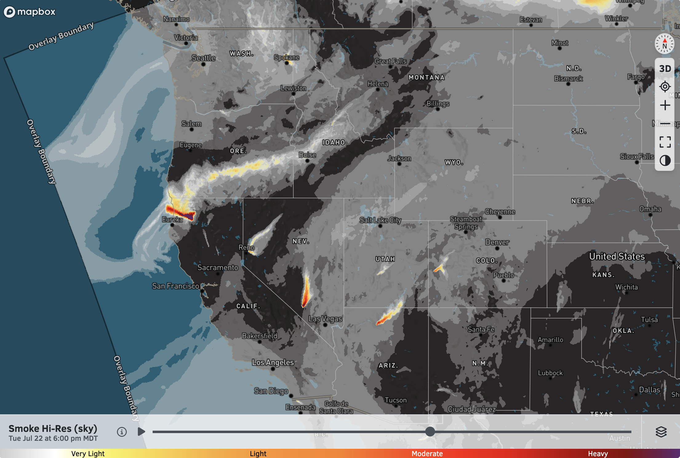
Wildfire Smoke Update:
While there are wildfires burning across the West, relatively mild temperatures (by July standards) and an increase in moisture in recent days have limited fire growth and smoke transport at a large scale (althoug this varies locally, of course).
Pockets of smoke will impact areas near and just downstream of active fires, but overall, the smoke forecast maps don't look too bad right now.
High-Res Smoke (Sky) Forecast for 6 PM Tuesday:
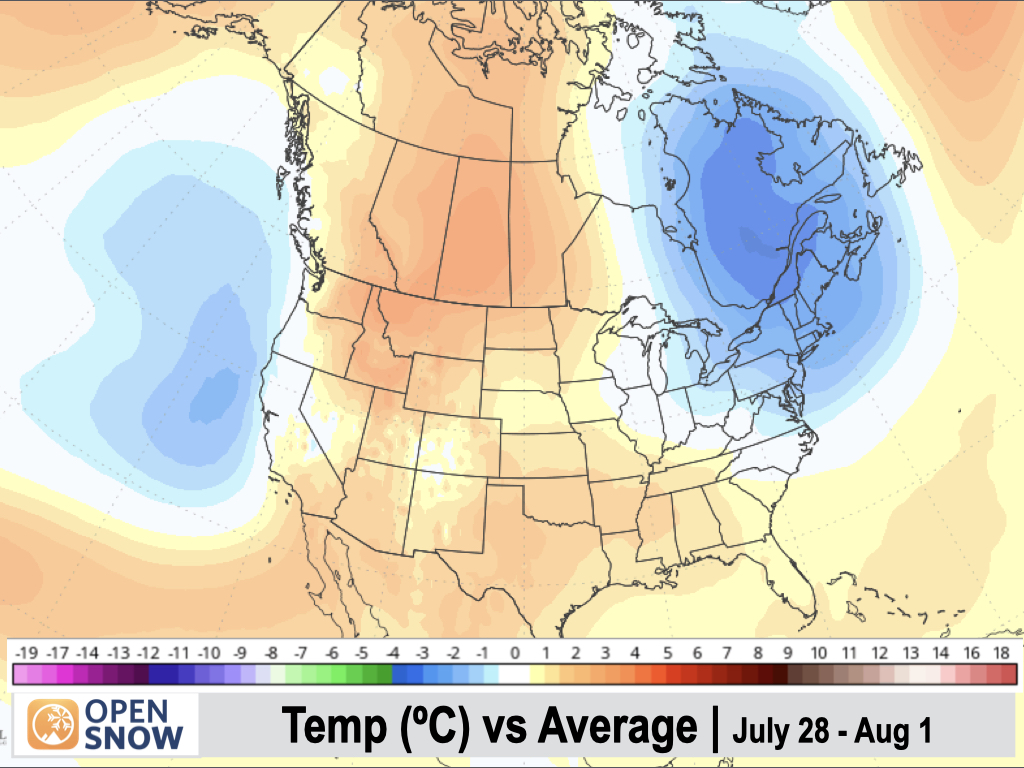
5-Day Temperature Outlook:
Below-normal temperatures are expected across California and, to a lesser extent, the Interior West, west of the Continental Divide. Areas near and east of the Divide will hang onto near-normal temperatures. It could be worse in late July, which is the climatological hottest time of year.

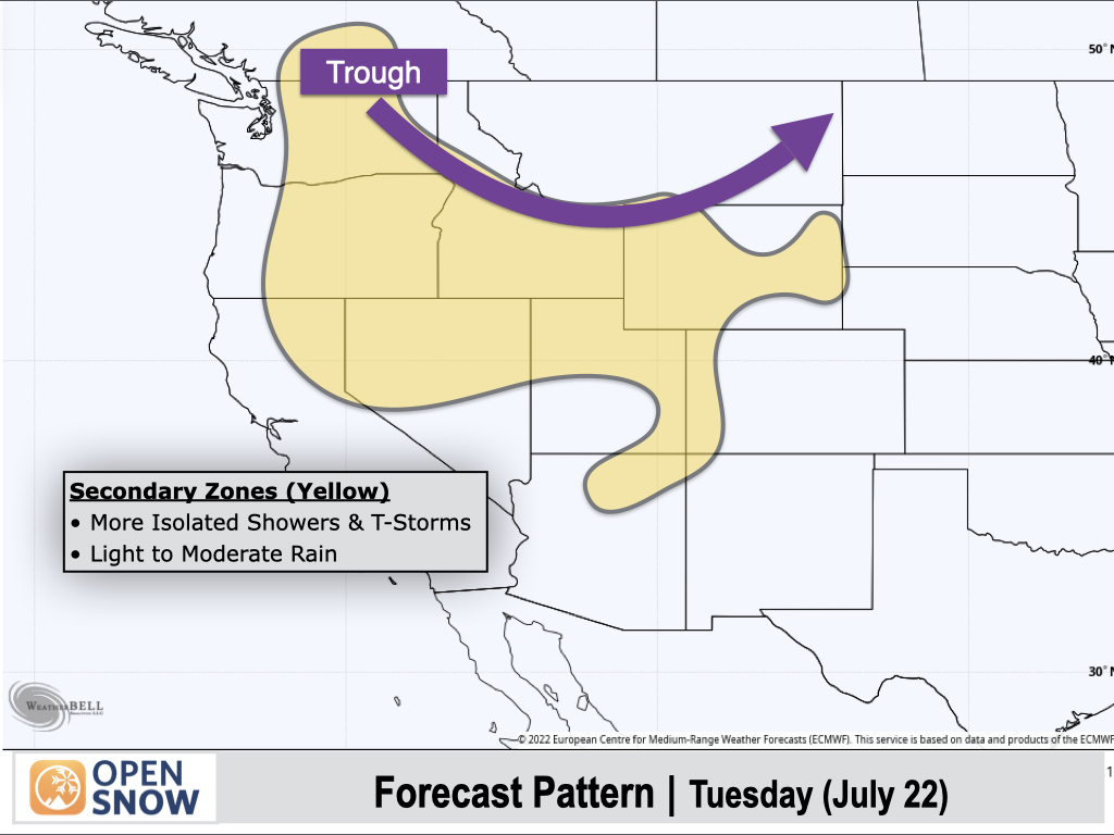
Tuesday (July 22):
Monsoon moisture will favor Colorado, New Mexico, and Southern/Eastern Arizona with scattered to numerous thunderstorms, some of which will produce heavy rainfall. There is also an elevated risk for flash flooding in desert/canyon areas, as well as fire burn scars.
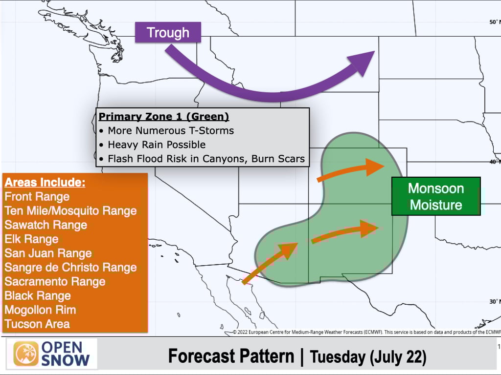
Another primary area of focus will be across the Northern Rockies, where a trough will be moving through. Significant Pacific moisture (by July standards) will accompany this trough with widespread showers and thunderstorms across Montana, Northern Idaho, Northeast Washington, and Northeast Wyoming, with locally heavy rain possible.

Yellow-shaded areas will be on the periphery of these weather features and will see more isolated shower and thunderstorm coverage, with most storms producing light to moderate rain.
Wednesday (July 23):
The trough will continue to move eastward across the Northern Rockies, while at the surface, a cold front will slide through Eastern Wyoming and eventually into Northern Colorado. Easterly winds will favor areas east of the Continental Divide for thunderstorms, with heavy rain possible.
Monsoon moisture will also linger over New Mexico and Western and Southern Colorado, resulting in another active thunderstorm day with heavy rain possible.

Areas further west will see isolated to scattered thunderstorms with most storms producing light to moderate rain.

Thursday (July 24):
Dry air pushing into the Southwest will lead to fewer thunderstorms in many areas, while a cold front sliding from Colorado into Northern New Mexico will reinforce moisture over these areas, leading to another active thunderstorm day.
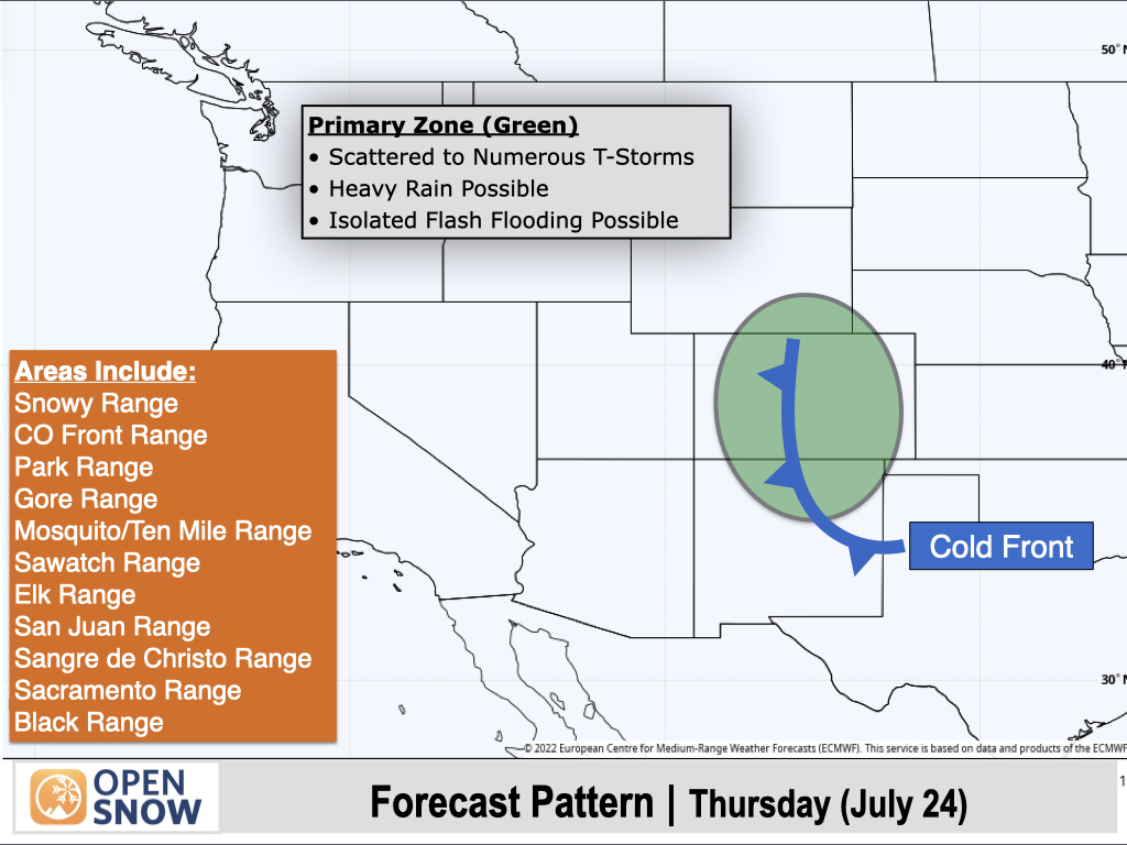
Wyoming and Northern/Eastern Utah will see more isolated thunderstorm activity with most storms producing light rain. An area of low pressure off the California Coast will also support isolated to scattered thunderstorms across the Sierra and Northern California.

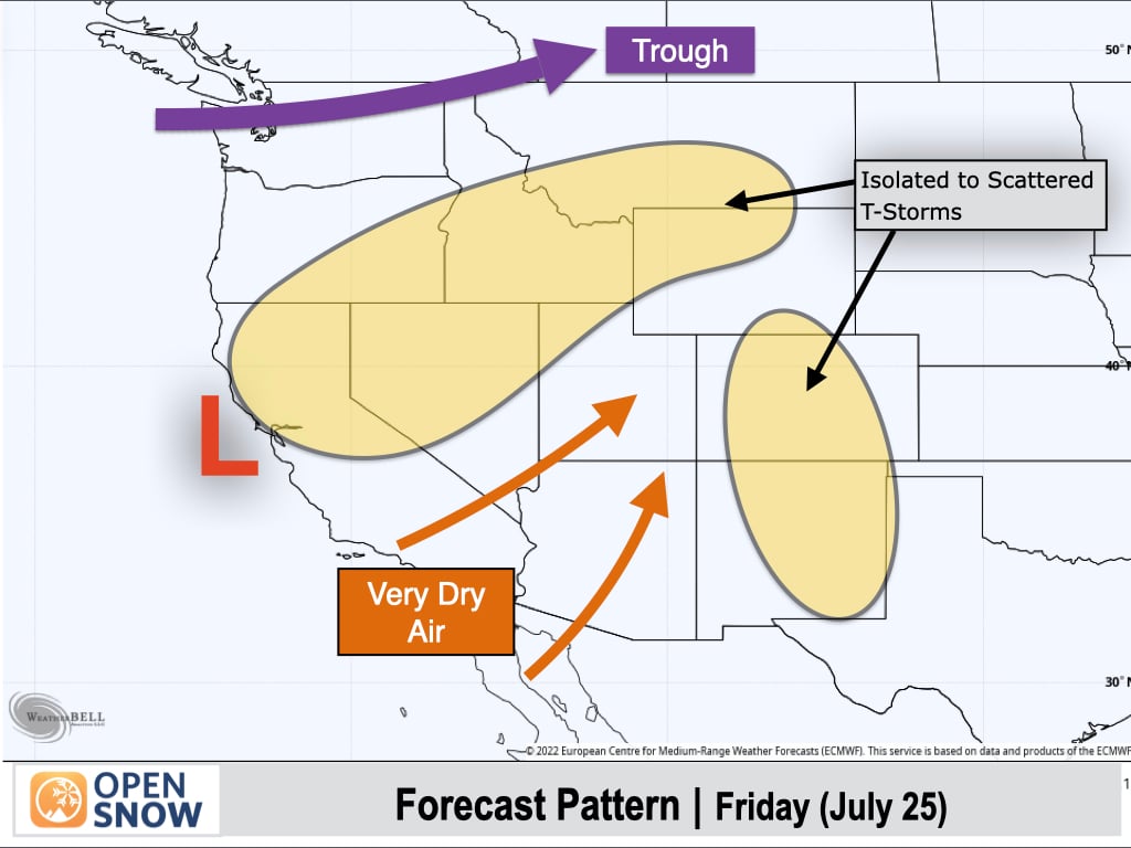
Friday (July 25):
Monsoon moisture will decrease substantially as dry air at the base of a low pressure trough near California pushes into the Western U.S. Only isolated thunderstorms are expected across Colorado and New Mexico with light rainfall.
Pacific moisture associated with the West Coast trough will result in isolated to scattered thunderstorms over Northern California, and increased west/southwest winds associated with a PNW trough will transport some of this moisture into the Northern Rockies, with scattered thunderstorms possible.
Saturday (July 26):
A similar pattern is expected with isolated to scattered thunderstorms over Northern California, the Northern Rockies, and Colorado and New Mexico. Most areas will see only light to moderate rain at most.

Extended Forecast
July 27-31:
Sunday, July 27th, will be another dry day with limited thunderstorm activity across most of the West (slightly better coverage possible over Northern California and Oregon), then monsoon moisture will gradually increase over Colorado and New Mexico heading into the week of the 28th. This still looks like a relatively weak monsoon initially for late July standards.
To the north, Pacific disturbances may bring occasional thunderstorm chances to Northern California and Oregon, and into the Northern Rockies.
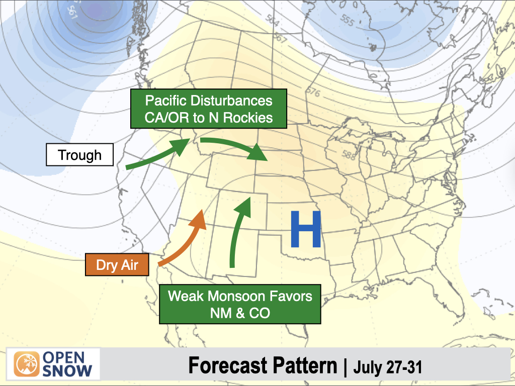
Troughiness near the West Coast will continue to support below-normal temperatures in California, while a ridge building over the Rockies will result in a return to above-normal temperatures for much of the Interior West.

August 1-5:
Heading into early August, we should see a gradual strengthening of the monsoon with Colorado and New Mexico likely being favored once again. However, moisture should also increase to some extent over parts of Arizona, Utah, and Wyoming, though there is still some uncertainty.
To the north, a trough-dominant pattern looks to continue to some extent near the West Coast, with Pacific disturbances potentially bringing occasional showers or thunderstorms across the northern-tier states from Washington to Montana.
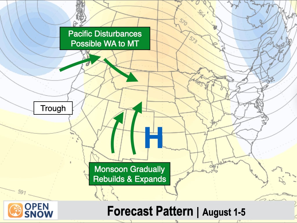
Temperatures look to remain near to below normal near the West Coast and above-normal across the Interior West heading into early August.
Thanks so much for reading! Next update on Wednesday (July 23).
Alan Smith
About Our Forecaster


