News

By Sam Collentine, Meteorologist Posted 10 years ago December 19, 2013
Weather for the weekend - Dec 20 to Dec 22, 2013
The big story this weekend will be snow and colder temperatures returning to the West. As I talked about in Monday's outlook, the split flow pattern will continue to move slowly across the United States through the weekend. This pattern will keep a stronger area of energy, a closed low, moving across the Southwest, while weaker impulses of energy make their way across the northern and central Rockies.
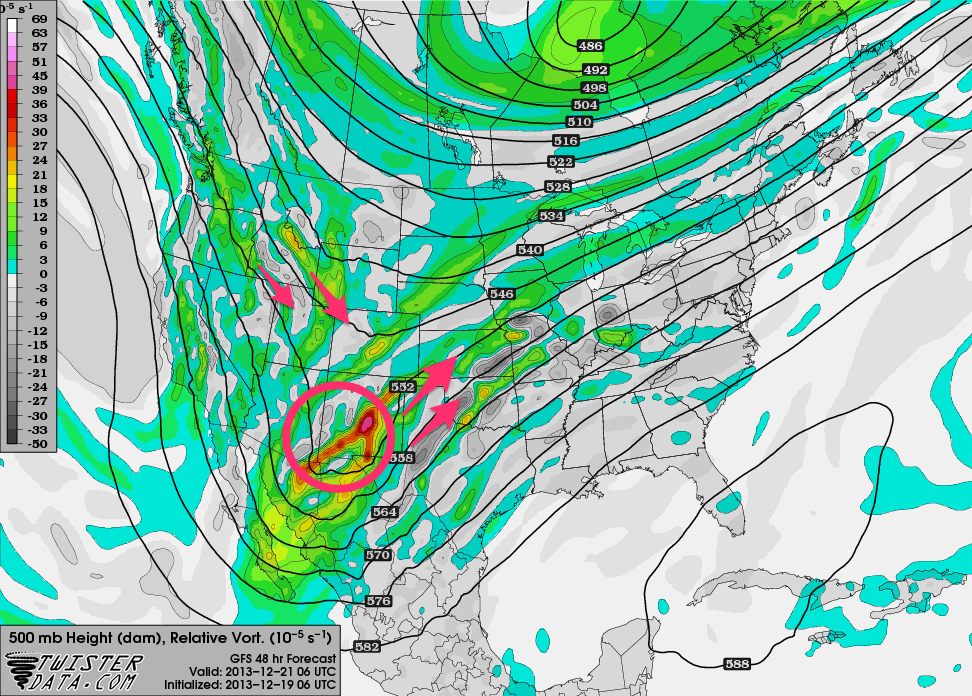
Areas of energy, or vorticity, according to the American GFS as of Friday night. Source: TwisterData.com, analysis by OpenSnow.
Washington, Oregon, Idaho, and Montana will see upwards of a foot of snow this weekend with two feet possible for some locations. Abundant moisture, along with the combined lift and energy, will allow for deep amounts of powder for this region of the country.
As for Utah and Colorado, the light hours of Friday will be primarily dry as the storm approaches from the Northwest. Snow will begin late Friday night and last through the weekend into Sunday.
For Utah, the best powder day looks to be Saturday as the heaviest snow is likely to fall throughout Friday night and into Saturday. When combined with Thursday's snow totals, the Wasatch Range of Utah is primed to have an amazing powder weekend. Look for the latest details in The Utah Daily Snow.
Colorado will see snow fall Friday night through Saturday night with a few stray showers on Sunday. The northern and central mountains will be favored this weekend as the storm approaches from the northwest. Like Utah, Saturday looks to be a great day for fresh turns in Colorado. Joel Gratz will always have the latest details in The Colorado Daily Snow.
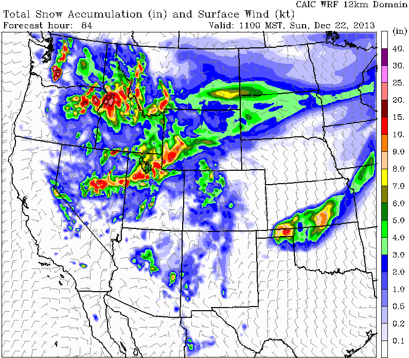
Total snow accumulation, according to the CAIC WRF Model, through Sunday morning. Source: Colorado Avalanche Information Center.
Looking at the rest of the West, the resorts of southern California will see a trace to 2 inches throughout the day Friday. As the stronger area of energy tracks across the Southwest, the resorts of Arizona will do well with a upwards of a foot possible for Sunrise Park.
The upper Midwest may also continue their snowy trend this weekend. Though there is still disagreement between the global models, lighter accumulations seem to be in store for the region. Andrew Murray will have the latest details as this storm approaches in The Upper Midwest Daily Snow.
Always remember to check our Powder Finder, forecasts for each mountain, and our Daily Snow posts throughout the weekend for more details.
SAM COLLENTINE
About The Author
Sam Collentine
Meteorologist
Sam Collentine is the Chief Operating Officer of OpenSnow and lives in Basalt, Colorado. Before joining OpenSnow, he studied Atmospheric Science at the University of Colorado, spent time at Channel 7 News in Denver, and at the National Weather Service in Boulder.
Free OpenSnow App


