News

By Sam Collentine, Meteorologist Posted 4 years ago August 31, 2020
NOAA’s 2020-2021 Winter Forecast

The US National Oceanic and Atmospheric Administration (NOAA) makes long-range forecasts each month.
We are going to show you their forecast for the upcoming winter, but first, a warning.
WARNING: Long-range forecasts are rarely accurate. These forecasts cover three months but we know that skiing quality improves and degrades with storm cycles that last a few days to a week.
Paying attention to the 1-10 day forecast (All-Access only) is the way that you'll find powder and give you the best information for your weekend trip or destination ski vacation.
Temperature Forecast During December, January, & February

Warm. This outlook is based on a general trend of increasing temperatures during the past years and decades.
Precipitation Forecast During December, January, & February

The northern half of the United States is in the "Probability of Above" zone, which means that the odds of above-average precipitation is higher.
The middle of the country is in the "Equal Chances" zone, which basically means that the odds of average, above-average, or below-average precipitation is about the same.
The southern half of the United States is in the "Probability of Below" zone, which means that the odds of below-average precipitation is higher.
But remember, 3-6 month forecasts have little to no value so don't get too excited or upset by where your favorite areas fall on this map.
What about El Niño or La Niña?

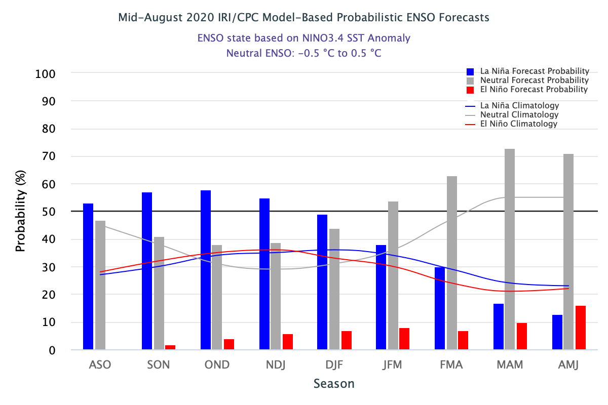
A strong El Niño or La Niña (which refers to ocean water temperatures in the central Pacific Ocean) can help us predict snowfall patterns during the winter.
For the upcoming 2020-2021 winter season, there's a ~50% chance that water temperatures will reach below-average (blue bar = La Niña), a less than 10% chance that water temperatures will be above-average (red bar = El Niño), and a ~40% chance that water temperatures will be near-average (grey bar = Neutral).
These model forecasts provide us with a signal for a La Niña event during the 2020-2021 winter season.
The official Climate Prediction Center outlook is similar to these model forecasts, calling for a 60% chance of La Niña for fall and a 55% chance for La Niña to continue through the 2020-2021 winter season.
Since long-range forecasts are rarely accurate or useful for finding great snow, here is a quick recap of our strategy for finding the deepest powder:
If you want the highest odds of deep powder, here are our six tips:
1) Live in a location that's close to mountains with the deepest snow.
2) If you can't live close to deep powder, wait until 7-10 days before booking your trip.
3) Even if you wait until 7-10 days before booking your trip, consider only booking to a general area.
4) If you have to book a trip far in advance, pick locations that statistics show have the deepest powder.
5) If you can't execute any of the above strategies, change your expectations for your ski trip.
6) Upgrade to All-Access for 10-day forecasts to help you find the pow.
Download the OpenSnow app and stay tuned to our forecasts for the latest weather updates.
SAM COLLENTINE
About The Author


