News

By Sam Collentine, Meteorologist Posted 11 years ago April 10, 2014
Weather for the weekend - April 11 to April 13, 2014
As we move into the middle of April, the majority of the United States begins to look and feel like spring. Ski resorts begin to close and mountain bikes replace skis. Though every spring, Old Man Winter seems to hide in the shadows and make an appearance just when we thought it was okay to put our skis and snowboards away for the summer. After a week of very warm temperatures and dry conditions, Old Man Winter will do just that. The northern and central Rockies will experience moderate to heavy snow on Saturday and Sunday as a mid-winter like system moves through the region. Stellar spring conditions can be found from coast-to-coast but if you are looking to make one last powder chase, head to British Columbia or the Rocky Mountains of the American West. Don't put away your skis and snowboards just yet because like every year, it will be mid-July and you will be dreaming about the return of DEEP powder skiing!
Total accumulated snowfall, according to the American GFS, through Sunday. Source: WeatherBell.com
The West will be under a warm west to northwest flow ahead of Saturday's storm with temperatures in the 40's across many mountain locations. British Columbia will experience heavy snow on Friday and into Saturday before the colder air rushes down into the American West. Beginning on Saturday, a closed low will look to join up with a progressive system dropping southeast out of Canada. Western Montana and Wyoming will begin to see snow showers on Saturday before the heaviest accumulations take aim at Colorado on Sunday. This storm will look to favor the areas along and east of the Continental Divide as a strong upslope flow develops on Sunday. If you are a fan of storm skiing, Sunday will be your day. If not, Monday morning should offer great conditions as well with a few inches likely after the lifts close on Sunday. Joel will have the latest every morning in The Colorado Daily Snow.

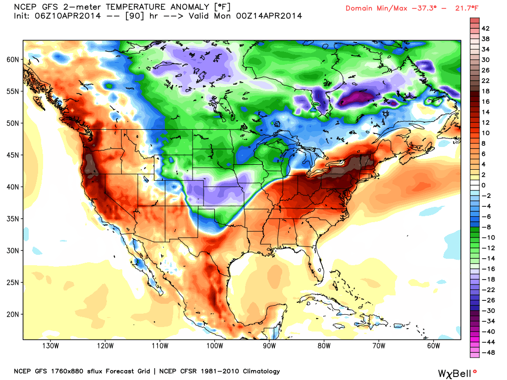
Above-average temperatures will be found across the West and East Coasts of the United States on Sunday. Below-average temperatures and snow will be found across the northern and central Rockies along with the Upper Midwest. Source: WeatherBell.com
As for the rest of the United States, spring skiing will be out in full force. Temperatures will reach the 50's across the Pacific Northwest and Lake Tahoe region with blue skies overhead. Excellent conditions if you're looking to grab some rays and have a relaxing day of skiing or riding. Brian and Larry will continue to update the Tahoe and Northwest Daily Snow as storms look to return by the middle of next week! All good things must come to end as Andrew in the Upper Midwest and Brian in New England wrap up their forecasting for the season on Friday. The resorts are beginning to close for the season in their regions with liquid precipitation becoming more abundant. Parts of the Upper Midwest will see a slight chance for snow late Sunday but rain will be the main culprit across the region. The far nothern reaches of New England will see a chance for snow on Friday but liquid precip will again dominate. It is sad to see the season end but it has been a great snow year for both the Upper Midwest and New England!
When you're up on the hill this weekend post pictures and updates using "LiveSnow", one of the features of our FREE iPhone and Android app.
Always check our Powder Finder and the forecasts for each mountain throughout the weekend for more details.
Sam Collentine | OpenSnow
> Checkout Liftopia for Discount Lift Tickets
About The Author


