News

By Sam Collentine, Meteorologist Posted 10 years ago January 2, 2014
Weather for the weekend - Jan 3 to Jan 5, 2014
For this weekend, the United States will be punched full of brutally cold temperatures and fresh snow. Areas of the upper Midwest will see chances for record low temperatures by the weekend's end, while New England will see an abundance of fresh powder on Friday morning. The northern Cascades and the inner West will also see decent accumulations come Friday into Saturday. This weekend looks primed for an amazing weekend of skiing no matter where you are in the United States.
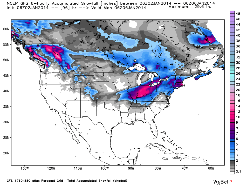
Total accumulated snowfall, according to the American GFS, through Sunday night. Source: WeatherBell.com
Deep powder and bone chilling temperatures will be found in the Northeast come Friday morning. "It's going to be darn cold out there over the next couple of days. Almost every resort will see highs below 10 degrees, and some resorts at elevation in the north won't even get above 0" according to our Northeast Meteorologist Brian Clark. The best accumulations will found in the Berkshires of western Massachusetts. It's a great time to be skiing in the Northeast and a sick day from work should be considered if you can swing it. Get the latest details in The New England Daily Snow.
As for the inner West, moderate to heavy accumulations will begin to take place Friday morning for the northern Cascades of Washington then eventually down into northern and central Colorado through Saturday night.
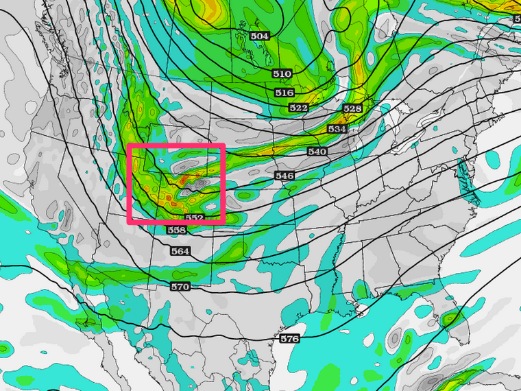
Area of storm energy (vorticity), according to the American GFS, that will swing down the inner West this weekend. Source: WeatherBell.com, analysis by OpenSnow.
The storm path is very similar to what we have been seeing over the past few weeks with northern Washington, the panhandle of Idaho, western Montana, Wyoming, and northern Colorado coming away with the highest totals. The best skiing will be found on Friday for the northern Rockies while Saturday looks to be the best in northern and central Colorado. As we have seen over the past couple of storms, northwest flow is king for many areas of northern and central Colorado so don't be surprised if totals approach a foot through Saturday. Evan and Joel will have the latest details and analysis for the inner West in The Utah Daily Snow and in The Colorado Daily Snow.
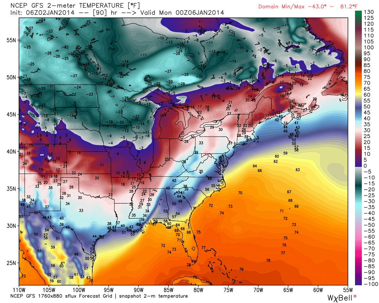
Sunday night temperatures, according to the American GFS, for the eastern half of the United States. Source: WeatherBell.com
As for the upper Midwest, lake effect snow will bring light to moderate accumulations to northern Wisconsin on Friday followed by another round of showers for Wisconsin and Minnesota on Saturday. Saturday's snow will be ahead of what could be record low temperatures for the upper Midwest. "Many areas will have a chance to see sub -30ºF temperatures right before sunrise, with the wind chill dipping into the -50º range" on Sunday night and into Monday morning according to our upper Midwest Meteorologist Andrew Murray. This should make for a very interesting NFL playoff game in Green Bay when the Packers take on the San Francisco 49ers Sunday afternoon. Stay up-to-date with the latest details in The Upper Midwest Daily Snow.
When your up on the hill this weekend post pictures and updates using "LiveSnow", one of the features of our new iPhone app. If your haven't already, download it here.
Always check our Powder Finder, forecasts for each mountain, and our Daily Snow posts throughout the weekend for more details.
Sam Collentine | OpenSnow
About The Author
Sam Collentine
Meteorologist
Sam Collentine is the Chief Operating Officer of OpenSnow and lives in Basalt, Colorado. Before joining OpenSnow, he studied Atmospheric Science at the University of Colorado, spent time at Channel 7 News in Denver, and at the National Weather Service in Boulder.
Free OpenSnow App


