South America Daily Snow

By Luke Stone, Forecaster Posted 2 years ago June 21, 2023
All Aboard the Storm Train!
Summary
The next 7 to 10 days look very active for the ski resorts in South America, with a barrage of storms on the way. Temperatures start out on the warm side and fluctuate a bit throughout this series of storms. Overall, the first round of storms will favor the north, before the heavy snow shifts to the central and south.
Short Term Forecast
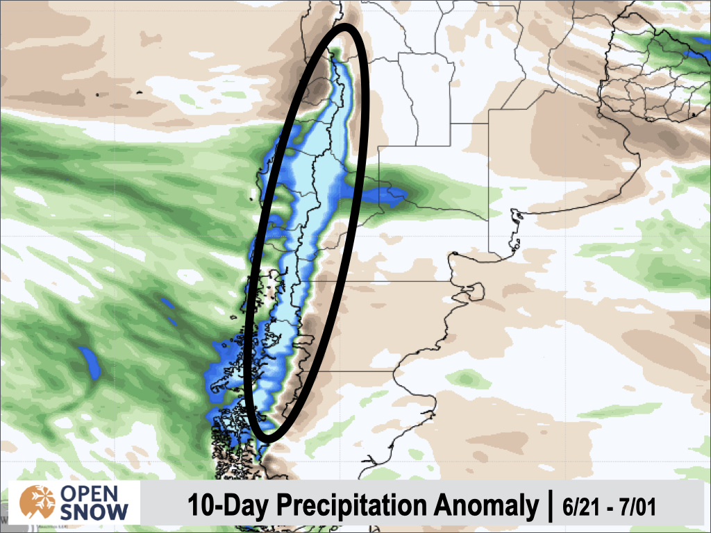
A lot of moisture is headed for the Andes over the next week, with several storms lined up in the South Pacific. Generally, freezing levels will be on the higher end at least through the first part of this active period, keeping the most significant accumulations at upper elevations. Snow and rain will be falling nearly non-stop as these storms come one after another, but I will do my best to break them up by storm. To get an idea of just how much moisture is headed this way, look at the precipitation anomaly over the next 10 days. This map shows, compared to normal, this area will receive between 200 and 500 percent of normal precipitation! WOW.
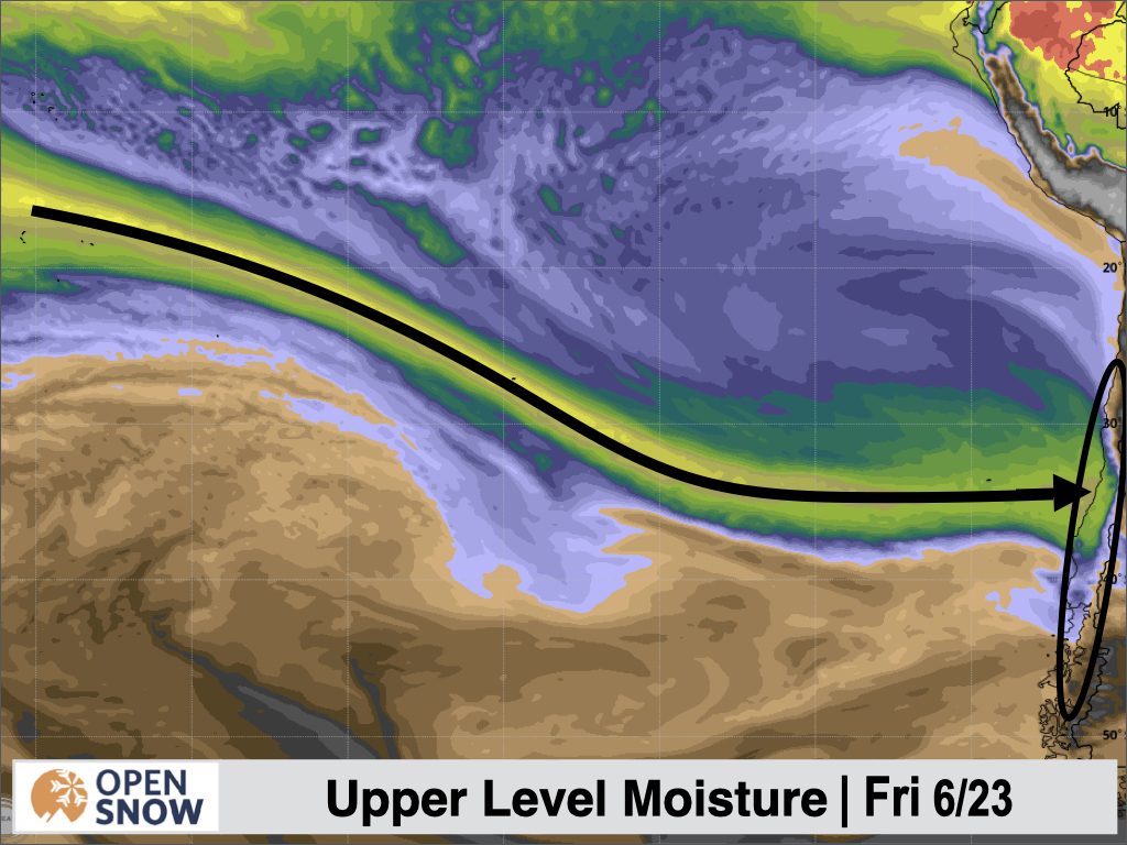
We have a HUGE plume of moisture stretching from the traps across most of the Pacific Ocean that will pump a boatload of precipitation across the region.
Forecast for Wednesday 6/21 - Saturday 6/24
The higher elevations in the north, especially those around Valle Nevado, will do best in this first storm, with some cold air staying in place through the end of the week. With the lower elevation resorts farther south, snow levels will often be hovering between the base and mid mountain.
This has the potential to deliver several feet at mid and upper elevations for the resorts east of Santiago, with the American model showing over 200 mm of precipitation in some areas through the end of the day on Saturday.
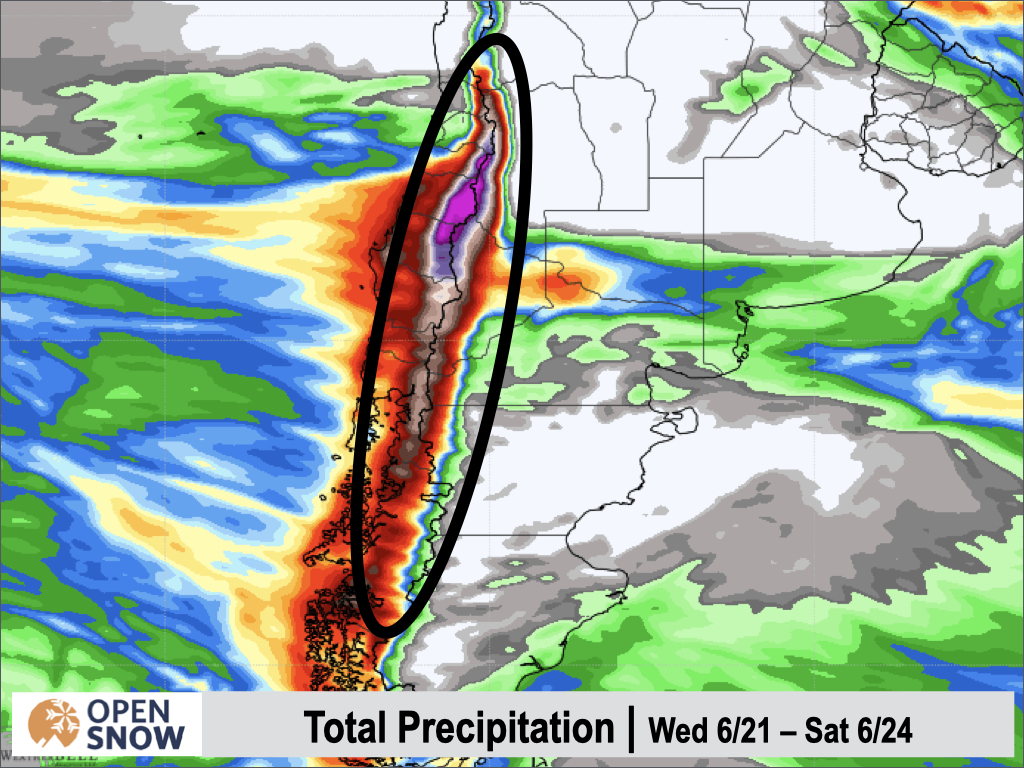
It's certainly a tricky forecast with these snow levels, but .5 - 1.5 + m are possible for Valle Nevada and the surrounding mountains. Even just a bit farther north near Portillo and Los Penitentes, the higher elevation colder air will be limited, so only 20 - 40 cms are likely. Farther South, high snow levels will limit snow totals, but 20 - 40 cms are still possible for Cerro Catedral. Elsewhere, at most of the lower elevation resorts, base a mid elevation snow will be limited.
Forecast for Sunday 6/25 - Tuesday 6/27
With no really break, the next storm arrives Saturday night/Sunday. While not impressive cold, this system will be a bit colder than the previous one. This wave will continue through Tuesday, and bring some solid totals to resorts like Pucon, Corralco, Antillanca, Law Araucarias, and Volcan Orsorno. The central Chilean and Argentinian resorts should do best, with 20 - 60 cms possible through Tuesday.
Extended Forecast
Outlook for Wednesday 6/28 - Sunday 7/2
The models show more storms during this period, with potentially some colder air as well. It would be nice to have a series of cold storms, especially with several resorts now open for the reason. I will keep you updated on this period throughout the next several forecasts.
Thanks for reading the South America daily snow! Follow me @lstone84 on Instagram to check out some new content I will be creating for the North American summer months. Let me know what you think.
About Our Forecaster


