South America Daily Snow

By Luke Stone, Forecaster Posted 2 years ago June 30, 2023
More Resorts Opening This Weekend, Big Storm Next Week
Summary
The recent snow across the Andes has allowed some resorts to open, with more to come this weekend. And with those openings, a long duration snow event is likely, focused on the central and southern resorts.
Short Term Forecast
Valle Nevado just opened on Wednesday the 28th, with Cerro Catedral on the 29th. Corralco and La Parva will open on the 30th, with Chapelco on July 1st.
Since my last post, the timing of the storm has changed a bit, with the heavy snow likely not arriving until Monday for most resorts. Before then, we stay warm and dry.
Forecast for Friday 6/30 - Sunday 7/2
Not much has changed for this period since my last post. Mainly dry and warmer than normal for most of the weekend, before some colder air arrives on Sunday as the first storm arrives to the south. A narrow band of snow may set up on Sunday that could get things started then, but this would only be for a small area. At the moment, where this band will set up is still a bit uncertain. Outside of this heavier band, there may be some light snow on Sunday as well.
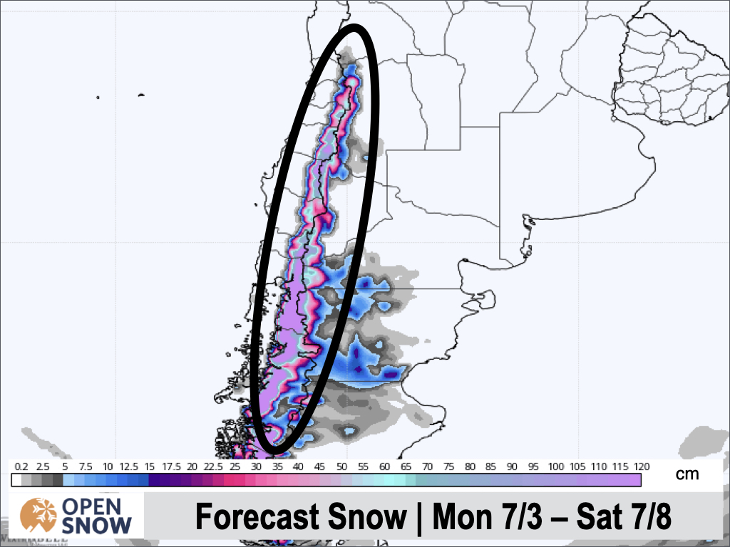
Forecast for Monday 7/3 - Saturday 7/8
The arrival of the next storm has been pushed back bit, with most models now showing the heavy snow developing Monday night, from south to north. Some light snow is again possible during the day on Monday before the heavier wave arrives Monday night. Winds will be strong and snow levels will be low, but expect strong gusts of 60 - 120 km/hr, especially on the volcanoes. Winds shouldn't be as strong at Cerro Bayo and Nevados de Chillan.
Central resorts like Pucon, Corralco, Antillanca, Volcan Osorno, and Las Araucarias will be favored, where .5 - 1+ m is possible between Monday and Saturday. For Nevados de Chillan, Cerro Bayo, and Cerro Catedral, expect 30 - 90 cms, so not far behind. Totals have trended down a bit for the northern resorts, with only 4 - 10 cms expected now.
Below is the European snow forecast for the period.
Extended Forecast
Outlook for Sunday 7/9 - Thursday 7/13
Another quick not on the long range pattern. Models are trending toward keeping the pattern active in the second week of July. All three major models show more snow around the 10th. The details need to still be worked out but I will be keeping an eye on this period for more chances for snow.
About Our Forecaster


