News

By Sam Collentine, Meteorologist Posted 11 years ago March 31, 2014
Weather for the week - March 31 to April 4, 2014
As we enter the month of April, the entire United States will look like mid-winter. The West will see heavy snow throughout much of the week as a very large system pushes in off the Pacific. The entire drought strickened state of California will be the likely winners. Blizzard conditions will be in place across much of the Upper Midwest as the system ejects out of the West at the weeks end. Wednesday and Thursday are the powder day picks this week so plan accordingly!
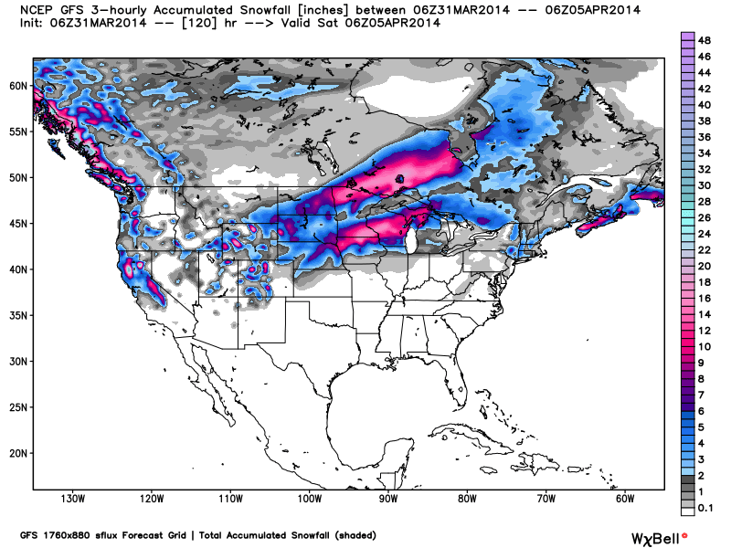
Total accumulated snowfall, according to the American GFS, through Friday night. Source: WeatherBell.com
It may of taken until the end of season but the Pacific Northwest and California are finally receiving deep powder skiing as we are all accustomed to seeing. Lake Tahoe, along with Mammoth Mountain in central California, will receive heavy snow Monday through Tuesday night as a large storm moves in off the Pacific. Excellent spring skiing will be out in full force so use those sick days and get up on the mountain! The Northwest will be north of the main storm track but will likely see a few inches on Monday and Tuesday. Mt. Bachelor and Mt. Hood will be the best options. Brian and Larry will break it all down in the Tahoe and Northwest Daily Snow.
As for the rest of the West, moderate to heavy snow will fall across Wyoming, Utah, and Colorado Monday night through Thursday morning. Moisture will be somewhat limited with this system but abundant storm energy will be in tow. Wednesday and Thursday are my picks for the best powder days as the storm tracks across Utah on Tuesday into Wednesday and across Colorado Wednesday into Thursday morning. Take advantage of the amazing spring conditions this week as it looks to really dry out and warm up next week! Click over to the Colorado and Utah Daily Snow for all the details.
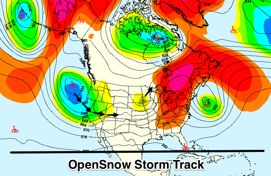
This week's storm will move in off the Pacific on Tuesday morning bringing a very active week to the Western US. It will likely arrive in the Upper Midwest on Friday. Source: Meteostar, analysis by OpenSnow.
Blizzard conditions will be found across the Upper Midwest on Monday and into Tuesday as a sharp storm moves through the region. The heaviest snow will be found across northern Minnesota on Tuesday with 1-2 feet expected. Conditions will dry out on Thursday before the next system ejects out of the West and into the region on Friday. It looks as though it will have a more southern track then the Monday/Tuesday storm favoring Wisconsin and parts of northern Michigan. Andrew will have the details in The Upper Midwest Daily Snow.
New England will see a few inches of snow on Monday mainly in the highly elevated areas to the north. Cold temperatures will be in place on Monday and Tuesday before seasonably warm and dry conditions move in on Wednesday. The next chance for snow will arrive late Friday but we are settling into the time of year when chances for rain increase dramatically. With that being said, the spring skiing is fantastic this year. Don't give up just yet! Brian will have all the details in The New England Daily Snow.
When you're up on the hill this week post pictures and updates using "LiveSnow", one of the features of our FREE iPhone and Android app.
Always check our Powder Finder and the forecasts for each mountain throughout the week for more details.
Sam Collentine | OpenSnow
> Checkout Liftopia for Discount Lift Tickets
About The Author


