News

By Sam Collentine, Meteorologist Posted 10 years ago February 13, 2014
Weather for the weekend - Feb 14 to Feb 16, 2014
For this weekend, a major winter storm continues to unfold along the East Coast while the Northwest eyes endless refills of deep Pacific powder. What began on Thursday for almost all of the East Coast will continue to push into the Northeast Friday providing what may be the best powder conditions of the season. Our Mid-Atlantic Meteorologist is calling this storm the biggest in 4 years! Much of the East Coast will be in gridlock but deep powder awaits at almost every resort within the Mid-Atlantic and New England.
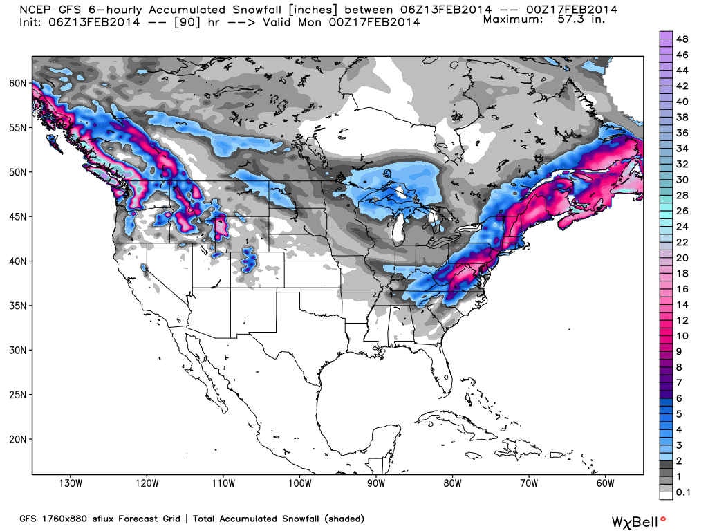
Total accumulated snowfall, according to the American GFS, through Sunday night. Source: WeatherBell.com
Mid-Atlantic and New England
The major winter storm is finally all coming together to provide the biggest storm of the season for the Northeast. The Mid-Atlantic region will have quite the powder day on Friday as upwards of a foot and possibly more will fall on many of the mountains areas. The sweet spots for the deepest accumulations look to be southern Pennslyvania and Virginia along Skyline Drive. As for New England, after a lull in the storm early Friday, it will once again kick in providing a few more hours of heavy snow for the White Mountains of New Hampshire as well as for Western Maine. Friday and Saturday look to be prime powder days for almost all of New England. If this storm wasn't enough, another weak storm will enter the Northeast late Saturday providing a few more inches to the weekend snow totals. Get the latest details from Justin and Brian in the Mid-Atlantic and New England Daily Snow.
Upper Midwest
An active weekend of weather is also in store for the Upper Midwest. With the Great Lakes nearing a total ice coverage of 90%, lake effect snow will begin to be less prominent going forward for the rest of the winter. After a winter of record cold temperatures across the Upper Midwest, this could be the first time this century that Lake Superior becomes completely frozen over. The all-time record for combined ice coverage for all the Great Lakes is 94.7 percent in 1979 so we will see. For this weekend, two weak Alberta Clippers will pass over the region providing 2-4" across many areas. The first system will move through on Friday while the second passes through late Saturday into Sunday. Andrew will have all the details in The Upper Midwest Daily Snow.
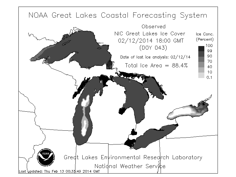
As of Wednesday, 2/12/2014, the total ice coverage for the Great Lakes was at a combined 88.4%. Source: NOAA
Colorado and Utah
Colorado and Utah will stay under an active pattern with a slight break Saturday through Sunday morning. The primary storm track will be too far north during this time period providing Utah and Colorado with a slight warm-up and dry conditions. After the previous ten days of deep snow accumulations, conditions will be great so don't shy away from the high country just because there will be a slight break in the action. Joel and Evan will break it all down in the Colorado and Utah Daily Snow.
Northwest
The Northwest has finally joined in on a very active storm pattern and there seems to be no end in sight. A low amplitude high pressure ridge will move east across the south-central US pushing storms into British Columbia along with Washington, Oregon, and Idaho. Free powder refills will be in abundance throughout the entire weekend! Our Northwest Meteorologist Larry Schick's powder pick this weekend is Whistler but if you're are looking to stay within the US, almost all areas of the Northwest will have amazing powder conditions. The next big storm will take aim at the region beginning on Sunday so click over to the Northwest Daily Snow for the latest details.
Lake Tahoe
As for Lake Tahoe, the jet stream will push farther south bringing the next system into the region on Saturday. Snow levels will start high but will continue to drop throughout Saturday night and into Sunday morning. Our Tahoe Forecaster is calling for 3-6" above 7000 feet and up to 9" along the crest west of the lake by Sunday morning. Brian will have all the details in The Tahoe Daily Snow.
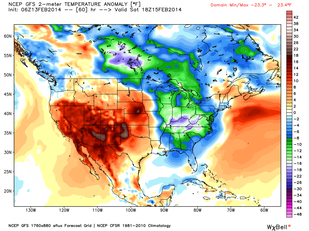
Temperature anomaly, or departure from the long-term average, as of Saturday afternoon. Source: WeatherBell.com
When you're up on the hill this weekend post pictures and updates using "LiveSnow", one of the features of our FREE iPhone and Android app.
Always check our Powder Finder and the forecasts for each mountain throughout the weekend for more details.
Sam Collentine | OpenSnow
PS - Want a ruler sticker? Go to your settings page and update your mail address so we can send you one.
About The Author
Sam Collentine
Meteorologist
Sam Collentine is the Chief Operating Officer of OpenSnow and lives in Basalt, Colorado. Before joining OpenSnow, he studied Atmospheric Science at the University of Colorado, spent time at Channel 7 News in Denver, and at the National Weather Service in Boulder.
Free OpenSnow App


