News

By Sam Collentine, Meteorologist Posted 11 years ago March 3, 2014
Weather for the week - March 3 to March 7, 2014
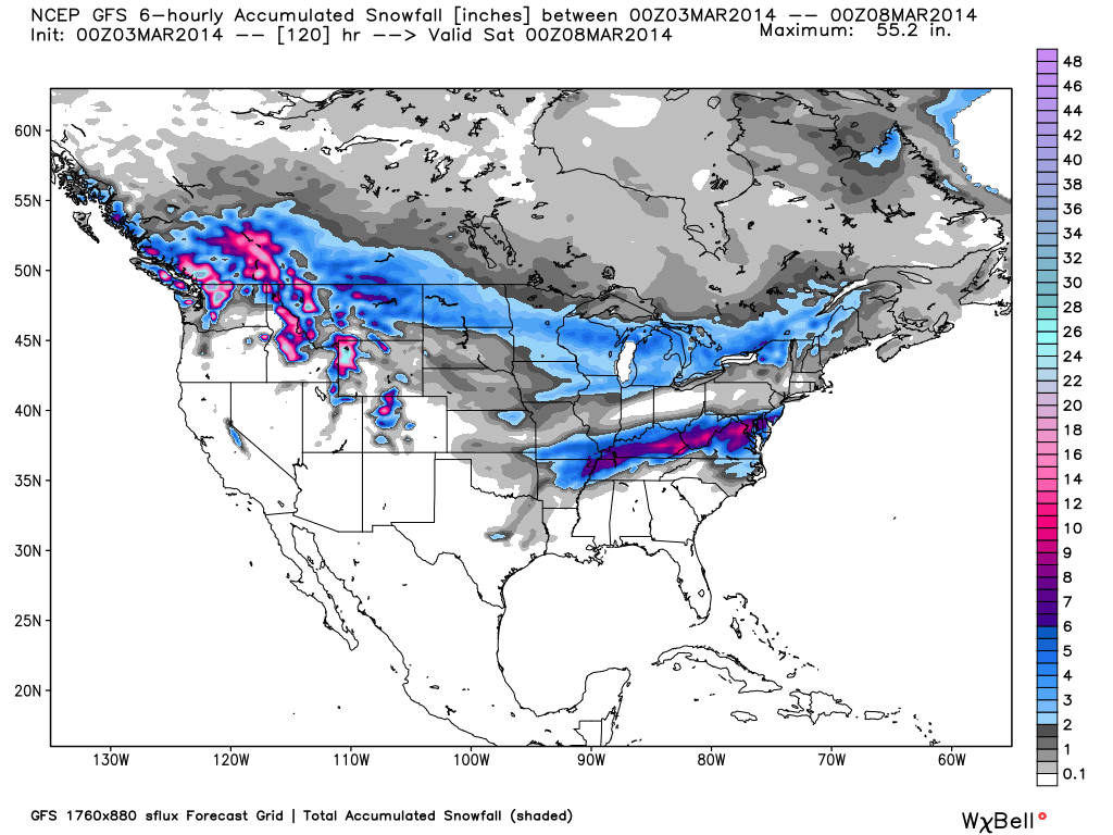
The Pacific Northwest, along with the inter-mountain West, will look to dominate the storm track with deep snow accumulations throughout the week. The Mid-Atlantic will see a good shot of snow on Monday while the Upper Midwest continues to see chances for light snow each day. Light to moderate snow will provide decent powder days on Tuesday and Wednesday for Utah and Colorado. A stronger system is in the works for the latter half of the week which should bring a good shot of snow to every region in the West.

Total accumulated snowfall, according to the American GFS, through Friday night. Source: WeatherBell.com
Pacific Northwest
The Pacific Northwest will see a series of storms throughout the week. The only downside to these systems will be higher snow levels creating a rain/snow mix within the lower elevations. The more northern and eastern resorts will likely see lower snow levels while the coastal resorts will see higher snow levels. Our Northwest Meteorologist Larry Schick is calling for 3-6 feet within the upper elevations with 1-2 feet in the lower elevations. Click over to The Northwest Daily Snow for the latest details.
Lake Tahoe
Light snow will fall across the region on Monday with snow levels falling into Monday night. Totals will range from 1-3 inches with better amounts likely found in the higher elevated areas. Tuesday and Wednesday will be dry until the next system moves into the region on Wednesday. This will be a stronger system but snow levels will again start out within the higher elevated areas. Things will clear out later on Thursday with milder weather moving in on Friday. Get all the details in The Tahoe Daily Snow.
Inter-mountain West
Heavy snow accumulations will take aim at the Grand Tetons of Wyoming throughout much of the week with Utah and Colorado seeing moderate to heavy totals on Tuesday and Friday. The strongest storm of the week will move through the region on Thursday night and into Friday. The best powder days this week will likely be Tuesday for Utah, Wednesday for Colorado, and Friday for both Utah and Colorado. Joel and Evan will break it all down throughout the week in the Colorado and Utah Daily Snow.

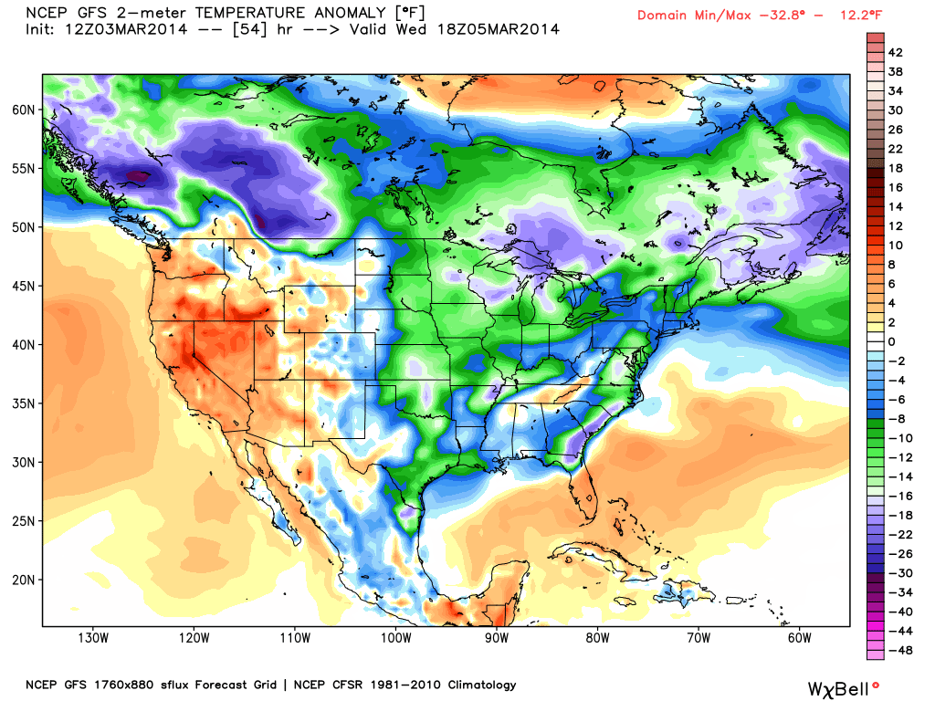
Above average temperatures in the West and below average temperatures in the East will dominate the US this week. Source: WeatherBell.com
Upper Midwest
The Upper Midwest will start out the week much of the same with brutally cold temperatures on Monday and Tuesday. There will be a slight chance for snow showers each day. Wednesday will provide a slight warm-up with a better shot for light to moderate snow accumulations. Lingering chances will be in place on Thursday before another good shot for snow moves into the region on Friday. Andrew will have the details in The Upper Midwest Daily Snow.
Mid-Atlantic and New England
A strong storm will move through the south-central Mid-Atlantic on Monday providing moderate to heavy accumulations for Virginia and West Virginia. This will be a quick hitter with the storm clearing out by late Monday night. Both the Mid-Atlantic and New England will be mostly dry until a weak clipper system moves through late in the week. Accumulations will be generally light with the higher elevated resorts in northern New England likely coming away with the highest totals. Click over to the New England and Mid-Atlantic Daily Snow for the latest details.
When you're up on the hill this week post pictures and updates using "LiveSnow", one of the features of our FREE iPhone and Android app.
Always check our Powder Finder and the forecasts for each mountain throughout the week for more details.
Sam Collentine | OpenSnow
> Checkout Liftopia for Discount Lift Tickets
About The Author


