US & Canada Daily Snow

By Zach Butler, Meteorologist Posted 3 months ago March 24, 2025
Spring Start for the West, Snow By the End of the Week
Summary
An upper-level ridge will bring warm spring conditions to the Western US to start this week as a colder storm system in the Eastern US brings light snow to the northern tiers. Spring in the West will be brief with a large storm system at the end of the week that will bring initial warm air and rain to the Northwest, but backside cold air with lowering snow levels and snow into the weekend.
Short Term Forecast
Helpful Links:
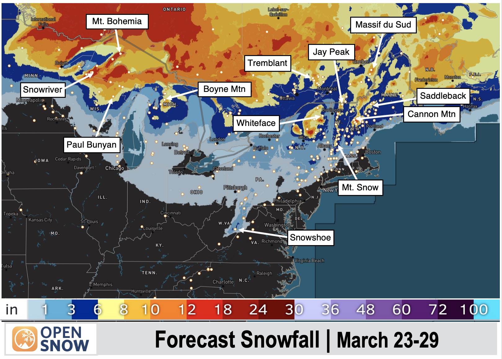
7-Day Snow Forecast:
A brief break in the storm track will bring spring weather to start this week. This will be short-lived with active and colder weather by this weekend. Snow will accumulate at the end of this week after Thursday, March 27. The heaviest snow is expected in Canada through British Columbia and Alberta.
More details from our local experts...

In the East, a storm at the beginning of the week will bring light snow with backside cold air associated with northwest flow. This will keep temperatures cool with a couple of areas of lake effect snow showers downwind of the Great Lakes. Snowfall will stay to the northern tiers of the Great Lakes and New England.
More details from our local experts:
Forecast for Mon (Mar 24) to Tue (Mar 25):
The Western U.S. will see southwesterly flow associated with an upper-level ridge and high-pressure system. This will bring warming and clearing conditions with several days of spring weather expected. The storm track will shift to northern British Columbia and Alaska with a few areas of snow and locally heavy snow along the coast. Snow levels will rise with this southwesterly push of warm air.
In the East, a storm system will bring a few areas of rain with a strong cold front that will change rain to backside snow showers. This will lead to light snow accumulations through the northern portions of the Great Lakes and New England.

Forecast for Wed (Mar 26) to Thu (Mar 27):
Relatively quiet weather will affect the U.S. and Canada as spring makes an appearance. The Western U.S. will continue to see mostly clear and warm conditions. A large storm system on Thursday will make its way into the Northwest and bring high snow levels with areas of rain. This storm system will bring snow on the north side of it into British Columbia and Alaska but snow levels will be high associated with the strong southerly push of warm air.
The Midwest and East will be on the other side of this weather pattern with cold northwest flow that will develop a few late-season lake effect snow showers. Snow accumulations will be minimal to light.

Forecast for Fri (Mar 28) to Sat (Mar 29):
Active and colder weather will return to the Western U.S. with strong northwesterly flow on the backside of the midweek warm storm system. This will bring lowering snow levels and snow accumulations to the Northwest and into the Rockies. The heaviest snow will fall along coastal British Columbia.
The Eastern U.S. will see a narrow area of precipitation associated with cold air and snow on the north side of it along the U.S. and Canada border. Warmer air to the south could bring mixed precipitation and a few areas of rain.

Extended Forecast
Outlook for Sun (Mar 30) to Thu (Apr 3):
The transition from March to April will feature an active Pacific storm track with several rounds of storms expected to develop and move into the Western U.S. This storm track will bring cold air with it, which is expected to bring late-season snowfall. Don't put your skis away yet!
The Eastern U.S. will see the opposite weather pattern as warm southerly flow brings spring weather. A couple of storms will track through the Great Lakes and bring mostly rain. Snow is possible on the northern and back sides of this storm track.

Thanks so much for reading! Next update on Wednesday (March 26).
Zach Butler
About Our Forecaster


