News

By Sam Collentine, Meteorologist Posted 11 years ago April 3, 2014
Weather for the weekend - April 4 to April 6, 2014
This weekend will feature a significant snowstorm across the Upper Midwest while a broad system moves through the Western United States. Minnesota, Wisconsin, and Michigan will see significant totals through Saturday morning as a powerful storm rips through the region. The Intermountain West can expect to see continuous snow showers Saturday morning through Sunday night with the highest totals taking aim at Wyoming, Utah, and Colorado. The month of April may be upon us but don't put your skis and snowboards away just yet!
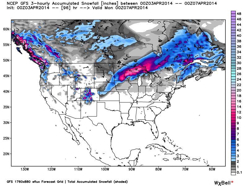
Total accumulated snowfall, according to the American GFS, through Sunday. Source: WeatherBell.com
Northwest & Lake Tahoe
The resorts of the Northwest will see light to moderate snow throughout the weekend. The only issue will be rising snow levels as rain can be expected across much of the lower elevated areas. Washington, Idaho, and western Montana can expect to see 5-10" through Sunday. Our friends to the north will also receive significant totals so head to British Columbia if your looking to make one of your last powder chases of the season. Larry will break down the latest in The Northwest Daily Snow. After a week where almost every location received 4-7 feet, the Lake Tahoe region will move into another drying trend this weekend. Light snow showers could dust the western edge of the basin on Friday morning but totals will be 1-2 inches at most. The best conditions of the season are in place right now so don't miss out! Get the latest details every morning in The Tahoe Daily Snow.
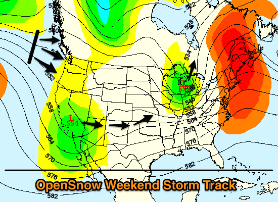
The storm over the Upper Midwest will begin to push north into Canada on Saturday as the next storm begins to move across the West. There will be enough energy and moisture to ignite light to moderate snow showers throughout the Pacific Northwest but higher snow levels are expected. Source: Meteostar, analysis by OpenSnow.
Intermountain West
The system that will move across the West this weekend will not pack a powerful punch but continuous showers through Sunday and into Monday. Dry conditions will be in place on Friday before snow moves back into Utah and Colorado on Saturday morning. Big totals are not expected but on and off snow showers throughout the weekend will create soft and fun conditions for early April. 5-10 inches can be expected through Sunday for Utah with 4-8 inches for Colorado. A jet stream induced northwest flow could may also set up over Colorado on Sunday night bringing a surprise powder day on Monday so that's something to keep an eye on. Warm temperatures and dry conditions will move into the West beginning on Monday and lasting throughout the week so enjoy the fresh snow while you still can! Evan and Joel will have the latest in the Utah and Colorado Daily Snow.
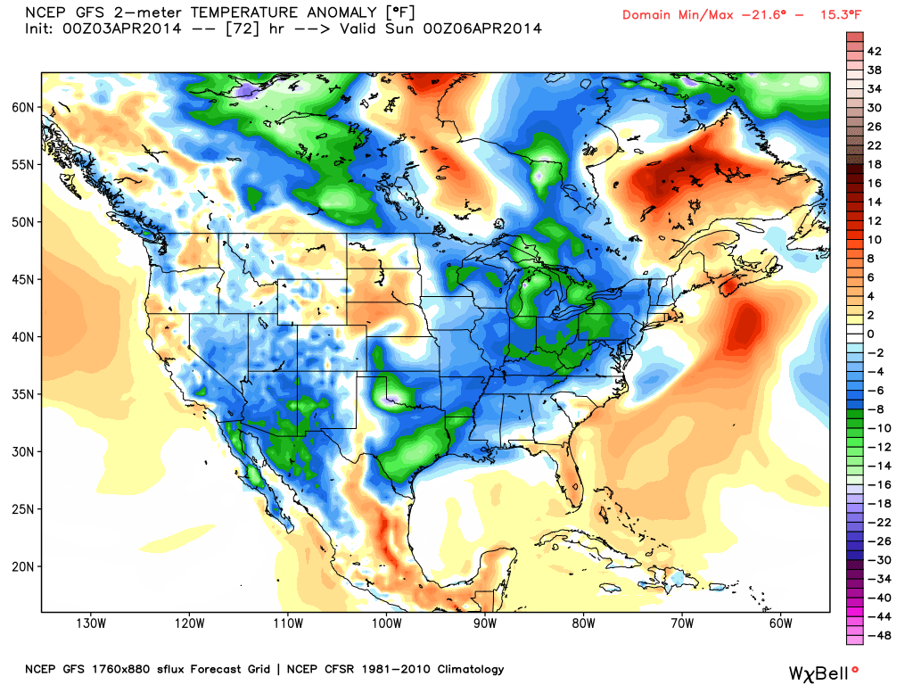
The temperature anomaly, or the departure from the long-term average, as of Saturday evening. This weekend will offer cooler temperatures across the United States as two systems move through the country. Source: WeatherBell.com
Upper Midwest and Northeast
The biggest story this weekend will be a major winter storm event in the Upper Midwest. Come Saturday morning, 1-2 FEET will be likely across parts of Minnesota, Wisconson, and northern Michigan. Abundant moisture, energy, and cold air will help fuel this storm and make for quite the snow event. Winter storm warnings will be in effect through late Friday night and I would not be surprised if numerous snowfall records were broken. Andrew will break down the latest details in The Upper Midwest Daily Snow. As for the Northeast, the upper reaches of New England including Vermont, New Hampshire, and Maine will see light to moderate snow on Saturday as the strong system tracks north out of the Upper Midwest. It's been a warm and dry week across the region so expect a lot of crunch underneith. A pattern change looks to bring more snow back to the region next week so click over to The New England Daily Snow for the latest updates.
When you're up on the hill this weekend post pictures and updates using "LiveSnow", one of the features of our FREE iPhone and Android app.
Always check our Powder Finder and the forecasts for each mountain throughout the weekend for more details.
Sam Collentine | OpenSnow
> Checkout Liftopia for Discount Lift Tickets
About The Author


