News

By Sam Collentine, Meteorologist Posted 11 years ago March 27, 2014
Weather for the weekend - March 28 to March 30, 2014
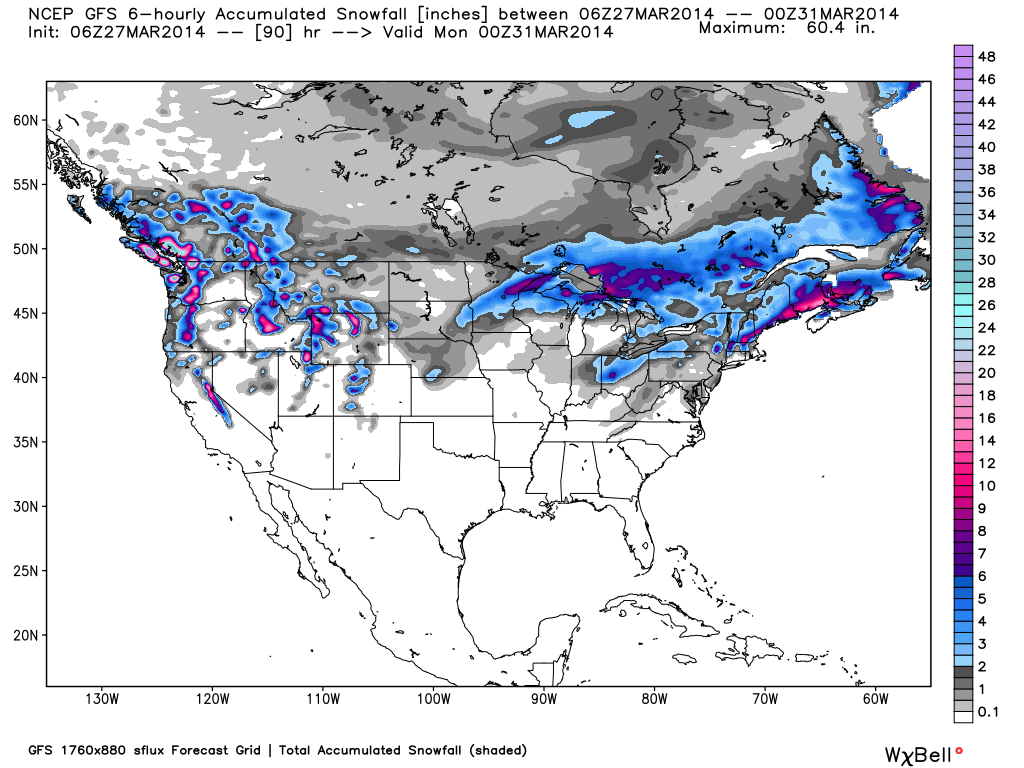
For this weekend, the West will continue to expand on it's excellent spring conditions while the Upper Midwest and Northeast continue to see chances for snow. A very promising storm is headed for Lake Tahoe on Friday night and into Saturday with up to 2 feet possible in the highly elevated areas. Better late than never! The inter-mountain West will experience dry conditions late Friday morning through Saturday afternoon before the next system pushes into the region. Sunday should be a great day! It may be late March but great conditions can be found from coast-to-coast!

Total accumulated snowfall, according to the American GFS, through Sunday. Source: WeatherBell.com
Lake Tahoe & Pacific Northwest
After dry weather on Friday, the next system will begin to push in off the Pacific come Friday night. Snow levels will start out high but will likely drop to lake level late Saturday after a cold front moves through. 1-2 feet can be expected in the highly elevated areas above 8000 feet. Drier conditions are expected on Sunday but lingering showers could stick around throughout the day ahead of the next system on Monday. Click over to The Tahoe Daily Snow for all the details. The Northwest will also see heavy snow throughout much of the weekend with the bullseye on Oregon. Deep powder will be found at Mount Bachelor with BIG totals come Sunday morning. Overall, this weekend will be provide tremendous skiing throughout Oregon and Washington so get up to the hill if you can! Larry will have the details every morning in The Northwest Daily Snow.
Inter-mountain West
Amazing spring conditions will be found all across the inter-mountain West throughout the weekend with another shot for snow arriving Saturday into Sunday. Idaho, Montana, and Wyoming will likely see heavy snow on Saturday and Sunday with up to 2 feet possible throughout central Idaho and in the Tetons of Wyoming. Jackson Hole will be spectacular! After a dry Friday and much of Saturday, Utah can expect to see 4-8 inches beginning on Saturday night. Sunday looks to be another great powder day! Turn to Evan and The Utah Daily Snow for the details. Colorado will then see it's next chance for snow likely begin on Sunday afternoon with 2-4 to 3-6 inches possible. This storm will pack a quick punch and will likely make the drive on Sunday night a tad bit tricky. Joel will have the latest in The Colorado Daily Snow.

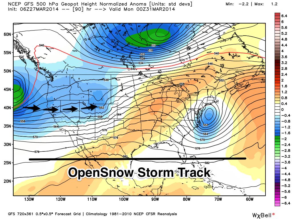
This weekend's storm will quickly push across the West as another system builds in the Pacific. Source: WeatherBell.com, analysis by OpenSnow.
Upper Midwest & Northeast
The Upper Midwest will see the storm that moved through on West on Thursday bring decent accumulations to the region early on Friday. Dry and warm weather will then move in on Friday and Saturday with the next chance for snow moving in on Sunday. Overall, spring conditions are trying to move into the region but old man winter just won't let go. Andrew will have the details in The Upper Midwest Daily Snow. As for the Northeast, the northern reaches of New England will likely see 2-4 inches on Friday before dry conditions take over on Saturday. The next chance for snow looks to move in on Sunday but there is still a lot of disagreement in the models as to the storm track and precipitation type. If the storm tracks more inland, New England could see a good shot for snow but the trend is more coastal and this is not good for the majority of the resorts. Brian will break down the details in The New England Daily Snow as the storm develops.
When you're up on the hill this weekend post pictures and updates using "LiveSnow", one of the features of our FREE iPhone and Android app.
Always check our Powder Finder and the forecasts for each mountain throughout the weekend for more details.
Sam Collentine | OpenSnow
> Checkout Liftopia for Discount Lift Tickets
About The Author


